Prepare for Mapping - FR Plans - Non RA - Tenement
This User Guide covers the plans settle process for those FR applications not within an RA that do not have a COF which is suitable for approval. For those applications with COFs being approved, although the mapping steps will not be required, consideration of the other settle steps is still necessary to ensure that a correct title sheet and cadastral unit is produced.
If the application contains a degree of complexity beyond your grade or level of experience, please follow agreed local processes for referral or re-categorisation upwards.
Process Steps
Make preparations for mapping
2.1 Log in to the Plan Creator.
2.2 In the Plan Viewer (PV), carry out an Index Map search to see if a draft cadastral unit (DCU) has already been created for your particular FR application.
2.3 If a DCU exists for your application number, use the guidance on Re-opening a DCU to open the DCU for editing in the Plan Creator.
2.4 If no DCU exists for your application number, use the guidance on Creating a DCU to open a new DCU for editing in the Plan Creator.
- Manually identify the property being registered using the Location Search function - this can be done using the address of the property, an existing title number for a flat in the same block, or by searching on the map.
- Ensure the seed point being generated is located within the property being registered.
2.5 Check if there is OS detail visible for the property being registered.
- Check the Basemap Investigation layer to see if newer map detail has been received but is not yet ready for release
- If the deed plan suggests that there may be newer OS detail that is significantly different from the versions on the Plan Creator/PV (for example, the site has been redeveloped), the assumption is that RoS do not yet hold the detail and the application may need to be referred to a referral officer to consider how it should be mapped.
2.6 Check the Application for Registration form - Part B to see if the question "If a plans pre-registration report has been issued by the Keeper in connection with this application, please quote the report number" has been answered.
2.6.1 If a report number has been provided on the form, check the Index Map to see if any plotted references or case notes are held in a COF related to that report. Such a COF may provide useful information about the extent of the property, common areas, etc. If you are in doubt about how you should proceed after reading a report, refer to a referral officer for guidance.
2.6.2 A report, and the documents submitted with the report, may also be viewed in the Reports Builder tool - the link to which can be found on the Plans Reports guidance page.
2.7 Check the Application for Registration form - Part B to see if the question "Has all or part of the plot of ground been delineated on the cadastral map?" has been answered.
2.7.1 If the answer is Yes, take a note if a cadastral unit or title number has been provided as this may be a previous registration (PR) of a flat or unit within the tenement.
2.8 Read any correspondence that is included with the application and held on the CMS, and take appropriate action.
- If you are in doubt about how you should proceed after reading the correspondence, refer to a referral officer for guidance.
Search the index map
2.9 Ensure a thorough interrogation of the index map is done by carrying out an Area search around the full extent of your property, checking any results that are returned in the (i) Title Layer, (ii) the Draft Plans Layer, (iii) the Index Layer. and (iv) the Basemap Investigation Layer.
2.10 Check if the DIR or the deed for extent refers to a deed of conditions.
2.10.1 If there is no deed of conditions referred to in the DIR or deed for extent, proceed to step 2.11
2.10.2 If there is a deed of conditions referred to in the DIR or deed for extent, check if a BUF (back-up file) index entry exists that contains mapping instructions for the deed of conditions.
2.10.2.1 If no BUF exists with mapping instructions for the deed of conditions, refer the case to a referral officer so the deed of conditions can be considered in line with the 2012 Act - in particular, the referral officer will consider if there are unidentified ownership interests in the deed of conditions that now require a plans reference on the cadastral map. See guidance page Mapping and Updating Deeds of Conditions for help.
2.10.2.2 If a BUF exists with mapping instructions for the deed of conditions, and there is a note saying the instructions have been updated for 2012 Act casework, take a note of these instructions and proceed to step 2.11.
2.10.2.3 If a BUF exists with mapping instructions for the deed of conditions, but there is not a note saying the instructions have been updated for 2012 Act casework, refer the case to a referral officer so the BUF instructions for the deed of conditions can be re-considered in line with the 2012 Act - in particular, the referral officer will consider if there are unidentified ownership interests in the deed of conditions that now require a plans reference on the cadastral map. See guidance page Mapping and Updating Deeds of Conditions for help.
- Once the mapping instructions have been updated and the case returned to you, take a note of these instructions and proceed to step 2.11.
2.11 Check if the cadastral unit being registered is affected by a CIL (Community Interest in Land) entry on the Draft Plan layer.
- If it is affected, refer the application to a senior adviser who will check the application against the entry in the RCIL (Register of Community Interest in Land).
2.12 Check if the cadastral unit being registered is affected by a TPO (Tree Preservation Order) entry on the index layer.
- If it is affected, take a note of the TPO number and any mapping instructions, or see TPO Plans Guidance page for guidance on which references are needed.
2.13 Check if there are any previously registered servitudes that affect the cadastral unit.
- As servitudes may be shown on the ungrouped title layer of the cadastral map or in supplementary data/additional cadastral map views held in groupings, all layers must be checked.
- If such a servitude exists, take a note of it.
2.14.1 If there is a PR within the tenement, check to see if they include any part of the flatted property that is being registered - see Further Guidance on Checking for competing titles within tenement steadings.
- Check any references on the cadastral map or on groupings showing supplementary data for the PR (these may be in the form of supplementary plans and SPLs for pre 2012 PRs).
- Check the descriptions in the casenotes for each registered flat in the tenement.
- Check the LRS for any verbal descriptions of rights to exclusive or common property, rights and pertinents in the title sheet for the PR.
- If there appears to be a competition in title with the flatted property being registered, its exclusive or common areas, rights or pertinents, refer to a referral officer to consider for rejection.
| Property being registered | Previous registrations (PRs) | Result | Guidance |
|---|---|---|---|
Exclusive ownership | Exclusive ownership | Competition in title | Pass to referral officer to consider rejection |
| Exclusive ownership | Ownership in common with other properties | Competition in title | Pass to referral officer to consider rejection |
| Ownership in common with other properties | Exclusive ownership | Competition in title | Pass to referral officer to consider rejection |
| Ownership in common with other properties | Ownership in common with other properties | Common area | See Check for Common Areas & Shared Plots - Tenement User Guide for actions to take |
| Property being registered | Previous registrations (PRs) | Result | Guidance |
|---|---|---|---|
Exclusive ownership | Exclusive ownership | Competition in title |
|
| Exclusive ownership | Ownership in common with other properties | Competition in title | Firstly, pass to HEO referral officer (who may wish to consult an SEO referral officer) to consider if either: (a) the subjects are intended to include a right in common/pro indiviso share in the area, or (b) if the subjects have no interest remaining in that area and should therefore be mapped to exclude the area. Once that decision has been made, then follow the appropriate guidance, below:
|
| Ownership in common with other properties | Exclusive ownership | Competition in title | Application received on or after 10 July 2018 - Subjects to be mapped to exclude the area of overlap Application received before 10 July 2018 - Pass to HEO referral officer, who will contact agent & give option of either (i) map to exclude or (ii) reject application. |
| Ownership in common with other properties | Ownership in common with other properties | Common area | See Check for Common Areas and Shared Plots User Guide for actions to take |
2.15 Use the FR tenement flow chart to establish if there is an existing tenement steading cadastral unit to be used or if a new one is required.
- If there is an existing tenement steading cadastral unit, take a note of the cadastral unit number
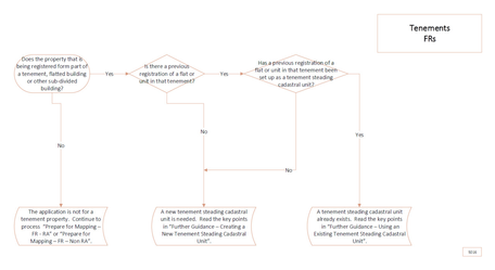
Visio 5016
2.16 Check for PRs in adjoining properties that overlap with the extent of the tenement steading cadastral unit.
2.16.1 If the area of overlap is an area of common ownership between the adjoining PR and flats or units within the current tenement steading, take a note of the details as consideration will be given later in the process to either setting this area up as a shared plot title sheet or proceeding with registration under the transitional provisions.
2.16.2 If the area of overlap appears to be a competition in title between the adjoining PR and the flat or units within the current tenement steading, follow the guidance in the tables, below.
| Property being registered | Previous registrations (PRs) | Result | Guidance |
|---|---|---|---|
Exclusive ownership | Exclusive ownership | Competition in title | Pass to referral officer to consider rejection |
| Exclusive ownership | Ownership in common with other properties | Competition in title | Pass to referral officer to consider rejection |
| Ownership in common with other properties | Exclusive ownership | Competition in title | Pass to referral officer to consider rejection |
| Ownership in common with other properties | Ownership in common with other properties | Common area | See Check for Common Areas & Shared Plots - Tenement User Guide for actions to take |
| Property being registered | Previous registrations (PRs) | Result | Guidance |
|---|---|---|---|
Exclusive ownership | Exclusive ownership | Competition in title |
|
| Exclusive ownership | Ownership in common with other properties | Competition in title | Firstly, pass to HEO referral officer (who may wish to consult an SEO referral officer) to consider if either: (a) the subjects are intended to include a right in common/pro indiviso share in the area, or (b) if the subjects have no interest remaining in that area and should therefore be mapped to exclude the area. Once that decision has been made, then follow the appropriate guidance, below:
|
| Ownership in common with other properties | Exclusive ownership | Competition in title | Application received on or after 10 July 2018 - Subjects to be mapped to exclude the area of overlap Application received before 10 July 2018 - Pass to HEO referral officer, who will contact agent & give option of either (i) map to exclude or (ii) reject application. |
| Ownership in common with other properties | Ownership in common with other properties | Common area | See Check for Common Areas and Shared Plots User Guide for actions to take |
2.17 In the CMS, read any existing Case Notes or Case Collaboration notes in case they give instructions or guidance on how the case is to proceed.
Registers of Scotland (RoS) seeks to ensure that the information published in the 2012 Act Registration Manual is up to date and accurate but it may be amended from time to time.
The Manual is an internal document intended for RoS staff only. The information in the Manual does not constitute legal or professional advice and RoS cannot accept any liability for actions arising from its use.
Using this website requires you to accept cookies. More information on cookies.
Feedback