This is the registration manual for 1979 casework.
Do not under any circumstances use the information here when settling 2012 casework. This resource has been archived and is no longer being updated. As such, it contains many broken links. Much of the information contained here is obsolete or superseded.
PIP 3/2004 Positional Accuracy Improvement Programme
Plans Information Paper 3/2004: Positional Accuracy Improvement Programme
Ordnance Survey (OS) are currently undertaking a national Positional Accuracy Improvement (PAI) Programme. This will allow the capture of data at 1:2500 scale to a greater absolute accuracy resulting in an improved and more consistent standard of mapping for rural areas. This affects a significant proportion of 1/2500 Landline maps throughout Scotland including some 1/1250 adjacent collar map tiles.
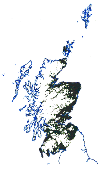
In brief the Positional Accuracy Improvement (PAI) programme has been necessary as a result of the historical transition from the paper based 'County series projection' to the metric National Grid. The issue has been highlighted in recent years by the use of technologies such as Global Positional Satellites (GPS), enabling the far more precise location of objects on the earth surface. The map below highlights shaded areas affected by the PAI programme amounting to some 37,000 map tiles in total.Ordnance Survey (OS) are currently undertaking a national Positional Accuracy Improvement (PAI) Programme. This will allow the capture of data at 1:2500 scale to a greater absolute accuracy resulting in an improved and more consistent standard of mapping for rural areas. This affects a significant proportion of 1/2500 Landline maps throughout Scotland including some 1/1250 adjacent collar map tiles.
The PAI is divided into two distinct programmes: Rural Towns and Rural Sweep which are running in tandem with each other:
- Small towns (36) which will involve a greater degree of ground re-survey work and upgrading to 1/1250 survey specification in some cases affecting approx. 360 map tiles. Targeted for completion by OS by Oct 2004 and
- Rural areas including villages, which will be, upgraded mainly through aerial photographic survey methods affecting approx. 36,640 map tiles due for completion by March 2006.
The data will be provided as a result of three changes, either:
- Positional Accuracy changes, e.g. shift of existing features owing to PAI or
- Real World update changes, e.g. a new house/boundary since the last survey or
- Surveyed changes, i.e. those that are made because of original survey error or change in specification.
Impact on RoS and Mapbase Maintenance
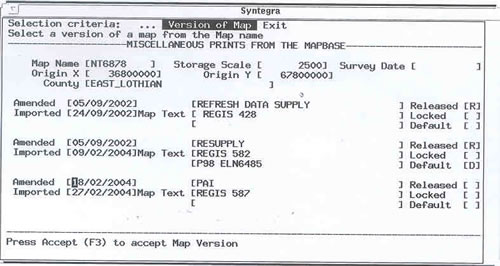
As a consequence Positional accuracy will have a significant impact on the workflow/resource of Mapbase Maintenance Section (MBMS) over the next 2 to 3 years. To date some small blocks of work have already been processed however the diverse nature of the newly supplied data makes the update process more difficult and time consuming. The main impact of this re-survey work is that the information held by ROS requires editing to match the new re-surveyed data within Landline. On receipt of any new map data to MBMS the maps will be rendered but not released on DMS to production staff until compare/remedial work has been completed. This map data can however be viewed on the DMS by accessing Version of Map on DMS forms and selecting latest version (not defaulted) - see example below for map tile NT6878 recently received as part of PAI release for East Lothian.
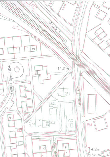
The example below illustrates existing new map data (green) viewed against the current default data (red) through the Map Comparitor tool. This highlights the significant shift of property boundaries as a result of PAI and also incorporates new survey (Real World) change in centre of map.
Given the scale of task for MBMS in undertaking PAI updates there will inevitably be some delays in releasing new map data. As a consequence all Plans staff are advised to always view the most up to date Land line Data through Version of Map. This will preempt any unnecessary survey requests or correspondence to agent(s). It should be noted that although this map data can be viewed through Version of Map, the DMS will not allow users to print off until it is released by MBMS. When encountering this situation MBMS should be contacted for advice as to approx. timescale for release of new map data.
09 April 2004
*
This is the registration manual for 1979 casework.
Do not under any circumstances use the information here when settling 2012 casework. This resource has been archived and is no longer being updated. As such, it contains many broken links. Much of the information contained here is obsolete or superseded.
*
The Manual is an internal document intended for RoS staff only. The information in the Manual does not constitute legal or professional advice and RoS cannot accept any liability for actions arising from its use.
Using this website requires you to accept cookies. More information on cookies.