To take a distance measurement in the Universal Web Viewer (UWV), start by selecting the measure distance tool on the left hand side of the UWV window.
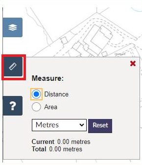
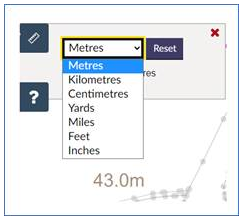
The tool measures the distance between any two points you would like to measure. You can change the measuring units by clicking on the drop down menu.
Measuring in feet will show feet and inches in the measurement box.
The measurement toolbox displays two measurements -
- the current distance from the last point you have clicked - this is a "live" measurement and will change as you move your cursor around the screen; and
- the total distance which is the sum total between each of the points you have measured.
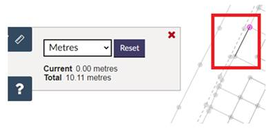
To use the measure distance tool, select the tool and click on the first point you want to measure from. Then move your cursor and click on the second point you want to measure to. The total distance between those two points will display in the measurement toolbox. In this example, this line measures 10.11m. Please note, the measuring line is now shown as a dashed line to aid clarity when drawing on the map. |
|
To continue to measure additional sections, clisk on the next point and so on until you have completed measuring. When you have finished, click the right mouse button to finish. The line and the total measurement will remain on the map until you start a new measurement, deselect the measure distance tool, or select a different tool. In this example, the total measurement of all sections measured shows as 16.15m. Please note, the measuring line is now shown as a dashed line to aid clarity when drawing on the map. | 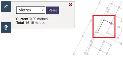 |
- If the distance in a deed is narrated in a unit that is not in the drop down list, various measurement converters exist on the internet to convert between measurement units.
- If it is an area measurement you need, all mapped polygons on the Index, Title, or Draft Plan layers have an area measurement in hectares displayed next to the polygon on the feature list when that Index, Title, or Draft Plan is viewed. Alternatively, the Measure Area tool can be used in the UWV.