| Info |
|---|
A point to note is that if we receive a deed plan at a scale of 1:50,000 then inclusion of digital data will still not allow us to confirm with any degree of certainty that the boundaries depicted by the digital data accurately reflect the detail on the plan as it is so small. A new, larger scale plan will still be required. An application such as that should be referred to a referral officer to consider for rejection. See the guidance page on Viewing deed plans and digital data at appropriate scales for more information. |
GIS
The GIS team can upload the digital data submitted into QGIS from which they can check the geometry.From here they can create a GEOJSON file for settlers, or upload the digital data into Plan Creator in a COF file for settlers to use.
If digital data was submitted to the digital data mailbox near the time of the original application date, this will be visible in UWV Plan Viewer as a COF file with a reference in the form "COF-GIS-1234". It will typically display as an unclassified green or brown hatch. The COF reference number corresponds to the GIS job number. The original data can be retrieved from the Customer Digital Data archive using this reference number, and instructions on how to obtain this read only data can be obtained from the GIS team if required.
Note: if not already submitted by the agent to the Digital Data email address with the application, any digital data that is subsequently submitted by the agent to assist in the registration process must be forwarded to the GIS Team to ensure that this information is archived,as we are under statutory obligation to archive this data. External guidance has been published on the RoS website explaining the current technical requirements (acceptable file formats, digital labelling, etc) - see Digital Data in the knowledge base.
If digital data is used as part of the registration process, appropriate notes should be added to the LRS Title N&I.
Seabed registrations
Where registration is in respect of an area of seabed, the task of accurately representing the position and boundaries of the plot can be difficult since many seabed plots will be located a distance from the coast where there is no OS detail. Special requirements are in place for such applications, in addition to the relevant conditions of registration. Deeds relating to plots of land that comprise seabed must contain a description of the plot based on the OSGB36 - British National Grid (ESPG:27700) projected coordinate system, as well as a verbal description and a plan identifying the location of the plot in relation to the coast of Scotland. The coordinates may be presented in a table format annexed to the deed or may be entered on the deed plan itself. While it will be possible to manually plot from the coordinates provided, this could prove impractical where the seabed plot is a large or irregular in shape, meaning there could potentially be hundreds or thousands of vector points. In such cases the use of digital data should be considered.
It is likely that most first registration deeds comprising seabed will be granted by The Crown Estate, who have confirmed that digital data will always be available. If the applicant has not submitted digital data and hasn't indicated in the application that they themselves hold digital data, the plans setter should follow the process steps below for requisitioning digital data from The Crown Estate. In any cases where The Crown Estate is not a party to the deed, check with a plans HEO before proceeding with the process steps for requisitioning digital data from an agent.
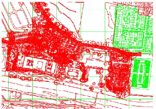 | 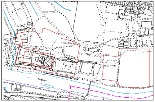 |
This image is an example of a CAD drawing that was submitted to identify common areas for a developing title in Ayr. You can see that these type of drawings look very complicated as they can contain a lot of information such as trees, drainage, manhole covers etc. The GIS Team within RoS has the expertise to extract the relevant data required for land registration and you can see the results in the next image. It is preferable though if digital data meets the requirements on the external guidance and only provides the references required in polygon format; any doubts speak to Plans HEO. | The polygons drawn in red against the OS background have been extracted from the CAD and imported to the mapping tool. Cleansing the data depends on the quality of the CAD, the separation and distinguishing of the layers that make up the drawing, and geocoding the data to the British National Grid. In good quality CAD drawings, the relevant detail can be picked out in about 15 minutes; poor quality ones can take several hours. This is why we have guidance in place for the preferred format of the data. |
How to recognise a suitable deed plan
Deed plans created using CAD or GIS software can be recognised using three indicators
- The plan will look as if it has been printed via a digital process
- The plan may state in the key or legend that it has been produced using a CAD or GIS system
- The plan has been created post-2005.
Acceptable digital data formats
See the published external guidance - Digital Data - for the current list of acceptable digital data formats.
Not all digital formats are acceptable as some are only digital image formats rather than CAD/GIS formats. The main difference between these formats is that the CAD/GIS formats contain data used to create maps, whilst the digital image formats simply depict a representation of a map.
Frequently asked questions
| Expand | ||
|---|---|---|
| ||
The GIS Team can be contacted via gis@ros.gov.uk. |
| Expand | ||
|---|---|---|
| ||
Sometimes this is difficult to ascertain from simply looking at the plan. However, if the plan is complicated and covers a large area. and meets the three indicators listed above, then it is worth contacting the agent to ask if it has been produced by a surveyor or cartographic firm using CAD or GIS software. A template email is available. |
| Expand | ||
|---|---|---|
| ||
No, asking for digital data for small or simple cadastral units will only delay the progress of the application. Settlers should be able to accurately plot the plan from the pdf image. If any references need to be georeferenced in QGIS and settlers are unsure how to do this, speak to a referral officer of contact Team Quantum. |
| Expand | ||
|---|---|---|
| ||
In most cases, the GIS Team will be able to load the data to the mapping tool as soon as they receive the data from the agent. However, if conversion and data cleansing are required a small delay may occur. |
| Expand | ||
|---|---|---|
| ||
An email template is available for your use - (see email template). You should also handle the receipt of the data from the agent so do not put the GIS Team's contact details in the email. |
| Expand | ||
|---|---|---|
| ||
CAD/GIS file sizes are normally small enough that the agent will email it to you. |
| Expand | ||
|---|---|---|
| ||
No. The imported data has been received from an external party and will not be digitised to the same criteria or have undergone the same levels of scrutiny as applied by colleagues. The GIS team only performs a technical check to make sure the data will import. The imported data should therefore only be used as a guide or template to the aid the mapping of the cadastral unit, and the plans settler is responsible for ensuring the mapping is accurate. Digital data does not replace the deed plan and the plans settler will still need to carefully compare electronic data with deed plan. The deed plan is the definitive extent. |
| Expand | ||
|---|---|---|
| ||
If the imported data differs from the deed plan, then it is the deed plan that takes precedence. We would not contact agent if there were a discrepancy between the deed plan and the imported data, instead we would map the cadastral unit as defined on the deed plan. If the deed plan extent differs from the OS Map then plans settlers should follow current consider or referral procedures. |
| Expand | ||
|---|---|---|
| ||
PDF (also JPEG, TIFF, GIF and PNG) are digital image formats (in other words, they are a picture of a map). A digital image has no scale or reference to the British National Grid, therefore it can't be used within the mapping tools. Only digital map data (not images) can be loaded to Plan Creator. Common digital data formats in CAD and GIS such as SHP, TAB and DXF can be converted to .json/geojson for import into Plan Creator. If the pdf plan submitted with the application is sufficiently large scale and clear enough to plot or be georeferenced from then there is no need to request digital data. If the pdf plan can be georeferenced in QGIS and settlers are unsure how to do this, speak to a referral officer of contact Team Quantum. If however the subjects cover a large area or have a lot of references then digital data can be of benefit in saving plotting time, and being the exact data used to construct the pdf plan, increasing the accuracy of the cadastral map. |
| Expand | ||
|---|---|---|
| ||
A scanned plan creates a digital image of a paper document. This image has no scale or reference to the British National Grid, therefore it cannot be imported into Plan Creator.The deed plan must meet the criteria set out Further Guidance - Check the Deed Plan is Acceptable. If the pdf plan can be georeferenced in QGIS and settlers are unsure how to do this, speak to a referral officer of contact Team Quantum. |
| Expand | ||
|---|---|---|
| ||
No. The deed plan must meet the criteria set out Further Guidance - Deed Plan Must Be Acceptable. If your deed plan is a floating shape, refer to a referral officer for rejection. |
| Expand | ||
|---|---|---|
| ||
The position and geometry will always be preserved from the CAD or GIS data, however if some references are missing they may not have been included in the data. If it is clear in the data that some parts are ownership and some parts are, for example, access, they will be imported in different colours, but mostly you’ll get an unclassified green hatch. |
| Expand | ||
|---|---|---|
| ||
This could be due to two problems;
The deed plan may be based on a different version of the OS map from the latest release of MasterMap in Plan Creator / UWVPlan Viewer. In these instances, the CAD or GIS data will be imported in relation to the edition of map it was created on and not that shown on our systems. Plans settlers can view prior versions of the map through the UWV Plan Viewer. However, as above, the imported data should only be used as a guide or template to aid the mapping of the cadastral unit. |
| Expand | ||
|---|---|---|
| ||
Digital data forms part of the application record if the subjects have not been registered, and once registered may form part of the archive record depending if it was used to inform the mapping of the subjects. Direct the enquirer to the Property and Information Team at searches@ros.gov.uk and they will process the request taking into account our statutory provisions. |
Voluntary Registration
There are some additional requirements when digital data is being submitted with an application for Voluntary Registration. Please see guidance page Digital Data for Voluntary Registrations for further information.