Digital Map Data & Digital Deed Plans

General

Occasionally pdf deed plans are submitted to RoS where the task of digitising the data or translating the actual position of a large plot can be a tricky or time consuming task. In the vast majority of these situations, plans settlers will have to use their skill and experience to translate the data from these images to digital format. However, the same problem may have arisen for the submitting agent. In some instances, where a historical deed plan doesn’t provide sufficient detail, no longer exists or where the deed inducing registration (DIR) represents a new plot of ground, a surveyor or cartographic firm may have been employed to perform a survey to determine the physical position of the legal boundaries. In such instances, the surveyor or cartographic firm may have used Geographical Information System (GIS) or computer-aided design (CAD) software to generate a new deed plan.

Occasionally, an applicant or their agent will contact the Keeper and offer to submit the deed plan in digital format. In addition, there will be times when the Keeper will consider requesting the digital data from the applicant or their agent, especially for larger titles. Such a process can save an enormous amount of time in plotting & should also result in a very accurate representation of the title. If the agent offers digital data, either as part of the intake or registration process, they are certifying the accuracy of that data.

Of course, it should be remembered that it is not the extent of the plot shown in the digital data that is being registered but the extent of the plot shown on a deed plan. The signed deed plan is still a legal requirement, and as such we must be satisfied that any digital data received is an accurate representation of the plot in the deed, and we must be able to identify the boundaries on the deed plan. Because of this, a plans HEO must be consulted before considering any requisition of digital data, or deciding to use digital data volunteered by an applicant or their agent.

If digital data is used as part of the registration process, appropriate notes should be added to the LRS Title N&I.


A point to note is that if we receive a deed plan at a scale of 1:50,000 then inclusion of digital data will still not allow us to confirm with any degree of certainty that the boundaries depicted by the digital data accurately reflect the detail on the plan as it is so small. A new, larger scale plan will still be required. An application such as that should be referred to a referral officer to consider for rejection. See the guidance page on Viewing deed plans and digital data at appropriate scales for more information.


GIS

The GIS team can upload the digital data submitted into QGIS from which they can check the geometry. From here they can create a GEOJSON file for settlers, or upload the digital data into Plan Creator in a COF file for settlers to use.

If digital data was submitted to the digital data mailbox near the time of the original application date, this will be visible in Plan Viewer as a COF file with a reference in the form "COF-GIS-1234". It will typically display as an unclassified green or brown hatch. The COF reference number corresponds to the GIS job number. The original data can be retrieved from the Customer Digital Data archive using this reference number, and instructions on how to obtain this read only data can be obtained from the GIS team if required.

Note: if not already submitted by the agent to the Digital Data email address with the application, any digital data that is subsequently submitted by the agent to assist in the registration process must be forwarded to the GIS Team to ensure that this information is archived, as we are under statutory obligation to archive this dataExternal guidance has been published on the RoS website explaining the current technical requirements (acceptable file formats, digital labelling, etc) - see Digital Data in the knowledge base.

If digital data is used as part of the registration process, appropriate notes should be added to the LRS Title N&I.


Seabed registrations

Where registration is in respect of an area of seabed, the task of accurately representing the position and boundaries of the plot can be difficult since many seabed plots will be located a distance from the coast where there is no OS detail. Special requirements are in place for such applications, in addition to the relevant conditions of registration.  Deeds relating to plots of land that comprise seabed must contain a description of the plot based on the OSGB36British National Grid (ESPG:27700) projected coordinate system, as well as a verbal description and a plan identifying the location of the plot in relation to the coast of Scotland. The coordinates may be presented in a table format annexed to the deed or may be entered on the deed plan itself. While it will be possible to manually plot from the coordinates provided, this could prove impractical where the seabed plot is a large or irregular in shape, meaning there could potentially be hundreds or thousands of vector points.  In such cases the use of digital data should be considered. 

It is likely that most first registration deeds comprising seabed will be granted by The Crown Estate, who have confirmed that digital data will always be available.  If the applicant has not submitted digital data and hasn't indicated in the application that they themselves hold digital data, the plans setter should follow the process steps below for requisitioning digital data from The Crown Estate. In any cases where The Crown Estate is not a party to the deed, check with a plans HEO before proceeding with the process steps for requisitioning digital data from an agent. 


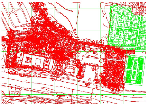
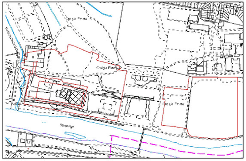
This image is an example of a CAD drawing that was submitted to identify common areas for a developing title in Ayr. You can see that these type of drawings look very complicated as they can contain a lot of information such as trees, drainage, manhole covers etc. The GIS Team within RoS has the expertise to extract the relevant data required for land registration and you can see the results in the next image.

It is preferable though if digital data meets the requirements on the external guidance and only provides the references required in polygon format; any doubts speak to Plans HEO.

The polygons drawn in red against the OS background have been extracted from the CAD and imported to the mapping tool. Cleansing the data depends on the quality of the CAD, the separation and distinguishing of the layers that make up the drawing, and geocoding the data to the British National Grid. In good quality CAD drawings, the relevant detail can be picked out in about 15 minutes; poor quality ones can take several hours. This is why we have guidance in place for the preferred format of the data.


How to recognise a suitable deed plan

Deed plans created using CAD or GIS software can be recognised using three indicators

  1. The plan will look as if it has been printed via a digital process
  2. The plan may state in the key or legend that it has been produced using a CAD or GIS system
  3. The plan has been created post-2005.


Acceptable digital data formats

See the published external guidance - Digital Data - for the current list of acceptable digital data formats.

Not all digital formats are acceptable as some are only digital image formats rather than CAD/GIS formats. The main difference between these formats is that the CAD/GIS formats contain data used to create maps, whilst the digital image formats simply depict a representation of a map.


Process Steps for requisitioning digital map data from an agent

 Process

1  When faced with large or complex applications, the first step is to recognise if the plan has been created using either CAD or GIS software - if the deed plan was created that way, then it can potentially be imported into the Plan Creator. Importing data digitally to the Plan Creator then allows you to save digitising or plotting time, or to quickly identify potential problems with adjoining registrations. CAD and GIS software is commonly used to construct deed plans, however, any deed plans drawn before 2005 will probably not be suitable.

2  Check with a Plans HEO that it is time/cost effective to requisition the digital data in the first instance.

3  If it is agreed that obtaining the digital data would be useful, the submitting agent should be contacted initially by email. (see email template).

  • Settlers will note that the template asks the agent if they have the CAD/GIS data that was used to create the deed plan, or could easily obtain it; and contains the link to the digital data requirements. It also states that the digital data does not supersede the deed plan, and that if we do not receive the digital data then we will plot from the deed plan. (Remember that if settlers cannot plot from the pdf version of the deed plan that was submitted with the application then rejections should be considered).

4  The agent will be allowed 21 days (to allow for the application to be completed within the 35 day SLA) for the submission of the digital data so hold onto the case until that time has elapsed, or until the digital data is received. If it is not received within that timescale, proceed to plot for the pdf deed plan, liaising with a Plans HEO if there are any doubts regarding the extent to be registered.

5  When the data is received, send it to the GIS Team digital data mailbox asking for it to be imported to the Plan Creator. Please also include the cadastral unit number relating to the data together with any other relevant details such as the address/name of the property as they will add this data to the archive.

The GIS Team will import the data to the Plan Creator as a COF file with a plans casenote, and will notify you by email of the COF name.

7  You can now use the COF as a template for, or as a reference within, the mapping of the cadastral unit.


Process Steps for requisitioning digital map data from The Crown Estate

 Process

1  When dealing with a seabed application where The Crown Estate are one of the parties and where digital data has not been provided, check whether the applicant has indicated in the application that digital data is available from them.  If so, proceed to step 3 of the "Process steps for requisitioning digital map data from an agent" above.

2  If there is no indication to this effect in the application, contact The Crown Estate to request a shapefile. It is important that the email provides sufficient information to enable The Crown Estate to identify the particular transaction, therefore ensure that the applicants and property description are specified.

3  The Crown Estate should send through a Shapefile within 1 to 2 days. The plans settler should hold the application until the data is received.

4  When you receive the data, send it to the GIS Team digital data mailbox asking for it to be imported to the Plan Creator. Please also include the cadastral unit number relating to the data as they will add this data to the archive.

5  The GIS Team will import the data to the Plan Creator as a COF file with a plans casenote, and will notify you by email of the COF name.

6  You can now use the COF as a template for, or as a reference within, the mapping of the cadastral unit.


Process Steps for importing digital map data submitted by an agent

 Process

1  If CAD/GIS data has been provided by the agent with the application, firstly decide if it would be of benefit to have it imported to the Plan Creator. Check with a Plans HEO that it is time/cost effective to use the digital data.

2  Send it to the Digital.data@ros.gov.uk mailbox (managed by the GIS Team), asking for it to be imported. Please also include the cadastral unit number relating to the data as they will add this to the archive. 

3  The GIS Team will import the data to the Plan Creator as a COF file with a plans casenote, and will notify you by email of the COF name.

4  You can now use the COF as a template for, or as a reference within, the mapping of the cadastral unit.


Frequently asked questions

 How do I contact the GIS Team?

The GIS Team can be contacted via gis@ros.gov.uk.

 How do I know that the plan I'm using has been created using digital data?

Sometimes this is difficult to ascertain from simply looking at the plan. However, if the plan is complicated and covers a large area. and meets the three indicators listed above, then it is worth contacting the agent to ask if it has been produced by a surveyor or cartographic firm using CAD or GIS software. A template email is available.

 Do I ask for GIS or CAD data from the agent for my house plot?

No, asking for digital data for small or simple cadastral units will only delay the progress of the application. Settlers should be able to accurately plot the plan from the pdf image. If any references need to be georeferenced in QGIS and settlers are unsure how to do this, speak to a referral officer of contact Team Quantum. 

 How long does it take to process?

In most cases, the GIS Team will be able to load the data to the mapping tool as soon as they receive the data from the agent. However, if conversion and data cleansing are required a small delay may occur. 

 How do I request the CAD/GIS data from the agent?

An email template is available for your use - (see email template). You should also handle the receipt of the data from the agent so do not put the GIS Team's contact details in the email.

 How will the agent send the data to me?

CAD/GIS file sizes are normally small enough that the agent will email it to you. 

 Does this mean the GIS Team have completed the mapping of my cadastral unit when the data is imported?

No. The imported data has been received from an external party and will not be digitised to the same criteria or have undergone the same levels of scrutiny as applied by colleagues. The GIS team only performs a technical check to make sure the data will import.  The imported data should therefore only be used as a guide or template to the aid the mapping of the cadastral unit, and the plans settler is responsible for ensuring the mapping is accurate. Digital data does not replace the deed plan and the plans settler will still need to carefully compare electronic data with deed plan. The deed plan is the definitive extent. 

 What should I do if the imported data differs from the pdf copy of the deed plan?

If the imported data differs from the deed plan, then it is the deed plan that takes precedence. We would not contact agent if there were a discrepancy between the deed plan and the imported data, instead we would map the cadastral unit as defined on the deed plan. If the deed plan extent differs from the OS Map then plans settlers should follow current consider or referral procedures.

 Why can't a PDF version of a deed plan be used?

PDF (also JPEG, TIFF, GIF and PNG) are digital image formats (in other words, they are a picture of a map). A digital image has no scale or reference to the British National Grid, therefore it can't be used within the mapping tools. Only digital map data (not images) can be loaded to Plan Creator. Common digital data formats in CAD and GIS such as SHP, TAB and DXF can be converted to .json/geojson for import into Plan Creator. 

If the pdf plan submitted with the application is sufficiently large scale and clear enough to plot or be georeferenced from then there is no need to request digital data. If the pdf plan can be georeferenced in QGIS and settlers are unsure how to do this, speak to a referral officer of contact Team Quantum. 

If however the subjects cover a large area or have a lot of references then digital data can be of benefit in saving plotting time, and being the exact data used to construct the pdf plan, increasing the accuracy of the cadastral map. 

 Why can't we just scan the deed plan & import it to the Plan Creator?

A scanned plan creates a digital image of a paper document. This image has no scale or reference to the British National Grid, therefore it cannot be imported into Plan Creator. The deed plan must meet the criteria set out Further Guidance - Check the Deed Plan is Acceptable. If the pdf plan can be georeferenced in QGIS and settlers are unsure how to do this, speak to a referral officer of contact Team Quantum. 

 The deed plan is a floating shape. Can I still use the GIS Team to import the data?

No. The deed plan must meet the criteria set out Further Guidance - Deed Plan Must Be Acceptable. If your deed plan is a floating shape, refer to a referral officer for rejection.

 A number of references on the deed plan have not been recreated on the IMP file, or they look different - what do I do?

The position and geometry will always be preserved from the CAD or GIS data, however if some references are missing they may not have been included in the data. If it is clear in the data that some parts are ownership and some parts are, for example, access, they will be imported in different colours, but mostly you’ll get an unclassified green hatch. 

 The OS map on my deed plan is different to that on the UWV/Plan Creator, or the imported data does not sit on the OS map as per the deed plan - what do I do?

This could be due to two problems; 

  • a difference in map editions 
  • Positional Accuracy Improvement (PAI) 

The deed plan may be based on a different version of the OS map from the latest release of MasterMap in Plan Creator / Plan Viewer. In these instances, the CAD or GIS data will be imported in relation to the edition of map it was created on and not that shown on our systems. Plans settlers can view prior versions of the map through the Plan Viewer. However, as above, the imported data should only be used as a guide or template to aid the mapping of the cadastral unit. 

 A customer has requested the digital data used to map the subjects. What should I do?

Digital data forms part of the application record if the subjects have not been registered, and once registered may form part of the archive record depending if it was used to inform the mapping of the subjects. Direct the enquirer to the Property and Information Team at searches@ros.gov.uk and they will process the request taking into account our statutory provisions.


Voluntary Registration

There are some additional requirements when digital data is being submitted with an application for Voluntary Registration. Please see guidance page Digital Data for Voluntary Registrations for further information.


Registers of Scotland (RoS) seeks to ensure that the information published in the 2012 Act Registration Manual is up to date and accurate but it may be amended from time to time.
The Manual is an internal document intended for RoS staff only. The information in the Manual does not constitute legal or professional advice and RoS cannot accept any liability for actions arising from its use.
Using this website requires you to accept cookies. More information on cookies.
Feedback