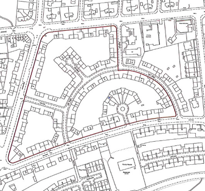
Angus Local Authority Properties - Rights to Park in Estate
A particular style of conveyancing has been used for many years in the sale of local authority properties in the county of Angus, predominantly in the City of Dundee. Each property is conveyed with the following right included in the text of the (Feu) Disposition by the local authority to the individual purchaser:
"...the proprietors of the subjects shall be entitled to park one motor car on any of the laybys within the Estate of which the subjects in this title form part, which Estate is shown within the boundary lines coloured black on the plan..."
The plan referred to is annexed to the deed, and the full extent of the Estate is sometimes shown on an inset section of the plan. Furthermore, there is generally a reference to the Estate in the burdens applied to the property:
"...the purchasers shall be bound to contribute to the cost of maintenance, repair and renewal of the whole footpaths, services, laybys, clothes poles and boundary walls within the Estate shown within the boundary lines coloured black on the plan and the upkeep of the ground and garden areas therein used as common..."
How to map the Estates
A variety of styles have been used over the years to reference such Estates in the land register, and latterly under the 1979 Act the policy was to verbalise such references. However, under the 2012 Act, it is necessary for a plans reference to be provided for the Estate in each case. Due to the particular nature of these rights to park, it has been decided to include these plans references in a grouping containing an additional layer of the cadastral map, and not to show the references on the primary layer of the cadastral map. This will reduce the "clutter" on the cadastral map when only titles are searched, and will make it a simpler picture when someone is searching in ScotLIS.
- The Estate should be mapped from the deed plan, including making use of the inset section.
- The Estate should be mapped in a separate grouping that contains an additional layer or view of the cadastral map.
- The Estate should be referenced with a brown edge and classified as Servitude & Burden.
- The defined extent of the Estate often differs from one deed to another, so you should only copy through the brown edge from another title if you are sure it is the same extent as is defined in your deed.
- In the title sheet, the brown edge should be described as being "edged brown on additional cadastral map view 1", where the number suffix corresponds with the number of the particular grouping. Please ensure that a title note is added to the LRS explaining this referencing description to the legal officer.
- For example, "The Estate shown with black lines on the plan to deed xxx has been edged brown on additional cadastral map view 1".
Registers of Scotland (RoS) seeks to ensure that the information published in the 2012 Act Registration Manual is up to date and accurate but it may be amended from time to time.
The Manual is an internal document intended for RoS staff only. The information in the Manual does not constitute legal or professional advice and RoS cannot accept any liability for actions arising from its use.
Using this website requires you to accept cookies. More information on cookies.
Feedback