Tree Preservation Orders (TPOs) for Plans Officers
How to name a TPO
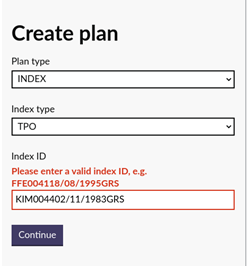
Naming Convention - CCCnnnnDD/mm/yyyyRRR
CCC = 3 character for the county in upper case (for example, FFE)
nnnn = daily running number padded with leading zeros to 4 digits (for example, 0035)
DD = day of recording padded with leading zero to 2 digits (for example, 09)
mm = month of recording padded with leading zero to 2 digits (for example, 07)
yyyy = year or recording (for example, 1991)
RRR = register in upper case (for example, GRS)
FFE003509/07/1991GRS.
Please note that it is only possible to create a new TPO within the Plan Creator if the naming convention is correctly followed. If an incorrect style is used when creating a new TPO, an error message will be produced in the Plan Creator:
Mapping a new TPO
A new TPO can be created and mapped in the Plan Creator, see the guidance at Opening or creating an index for details on how to open or create an index file. It is also possible to open an existing TPO for editing or updating.
TPOs will fall into three categories:
1 TPOs affecting areas of ground or groups of trees shown edged or tinted on the TPO plan
Identification on Index layer:
- yellow edge
- The TPO index entry casenotes should read The TPO affects trees within the land edged yellow
- On receipt of an FR or TP which is affected by the area edged yellow, the plans settler should consult the legal settler to determine whether or not a reference will be required on the cadastral map for the part of the property affected by the TPO. If necessary, the casenotes should be updated to reflect the legal settler's requirements for future applications affected by the TPO. If the TPO is affected by an RA, mapping instructions may already exist and the above action may not be necessary.
2 TPOs affecting specific trees shown on the TPO plan
Identification on index layer:
- For TPOs affecting specific trees, it is not always necessary to mark the position of each individual tree on the index map as it is sometimes the case that a reference will not be required within the title sheet for each tree. Instead, the full extent of all properties affected by the TPO (for example, house plots and industrial units) should be edged brown on the index layer and the casenotes for the index entry should refer the settler to an archived copy of the TPO plan depicting the individual trees
- The TPO index entry casenotes should read The TPO affects trees within the area edged brown on the Index Map. If Title plan references are required by Legal for these individual trees, they should be arrowed and lettered T in red on the cadastral map. No cadastral map reference should be brought forward for the area edged brown.
- For TPOs affecting specific trees where there are only a small number of trees, or where it is clear that individual references will be required in the title sheet, the labelling function in the Plan Create may be used to arrow and letter T in red each tree on the Index Map within the brown edge
- The TPO index entry casenotes should read The TPO affects the trees arrowed & lettered in red within the area edged brown in the Index Map. If Title Plan references are required for these individual trees, they should be arrowed & lettered T in red on the cadastral map. No cadastral map reference should be brought forward for the area edged brown.
- By edging the affected area in brown, this allows the auto ident process to identify applications which may be affected by the TPO.
- On receipt of an FR or TP which is affected by the area edged brown, the plans settler should consult the legal settler to determine whether or not a reference will be required on the cadastral map for any of the individual trees. If necessary, the casenotes should be updated to reflect the legal settler's requirements for future applications affected by the TPO. If the TPO is affected by an RA, mapping instructions may already exist and the above action may not be necessary.
3 TPOs affecting groups of trees and specific trees shown on the TPO plan
Identification on index layer:
- For TPOs affecting both groups of trees and specific trees, it will be necessary to use a combination of the two mapping & referencing styles set out, above.
Registers of Scotland (RoS) seeks to ensure that the information published in the 2012 Act Registration Manual is up to date and accurate but it may be amended from time to time.
The Manual is an internal document intended for RoS staff only. The information in the Manual does not constitute legal or professional advice and RoS cannot accept any liability for actions arising from its use.
Using this website requires you to accept cookies. More information on cookies.
Feedback