Research Areas for Plans Officers
1 Opening an existing RA for editing
Research Areas that need amendments to their extents, plans references or casenotes can be re-opened within the Plan Creator. See Re-opening an Existing Index in Plan Creator for details.
2 Updating RA notes
As existing RAs were created when the 1979 Act was in operation, they need to be considered in light of changes to policy and practice connected with 2012 Act. The RA casenotes are then updated to provide 2012 Act-compliant instructions. In addition to this, the mapping instructions in many RAs will need to be updated to take into account the changes in mapping practice brought about by the replacement of the DMS by the Plan Creator.
A Updating the casenotes in straightforward RAs
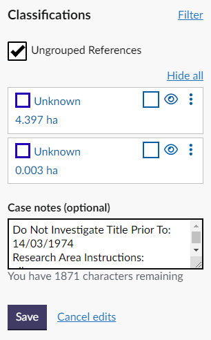
Once the RA has been selected and opened within the Plan Creator, the Case notes can be updated. Once the editing has been completed, click the Save button to finish the update. |
B Updating the casenotes in complex RAs with extensive notes
For RA notes, the number of characters is limited to 2000. In rare situations with more complex RAs, the casenotes may exceed this number of characters. In DMS mapping, a BUF was created to add more notes. This practice has ceased with the introduction of the Plan Creator. When the character limit is reached the text will not appear when entered.
RAs with very complex mapping instructions which would possibly be affected by this issue should be updated by a Plans EO.
- Where possible, try and abbreviate the notes to free up characters.
If the required mapping notes cannot be entered into the text box, then the 1979 mapping instructions should be copied and moved into the RA notes in the LRS.
Switch from Plans Settle LRS permissions to Plans NAP_MAP LRS permissions. If you don't have NAP_MAP permissions, these can be requested using the RoSNOW portal. | |
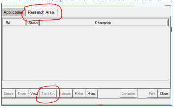
Change the tab in the LRS from Applications to Research Area, and then Take On the RA. It should be possible to take on the RA from any ‘NAP’ location, e.g. even if it is located at NAP_Legal Settle it can still be taken on at NAP_MAP. If the RA fails to be taken on, raise a ticket through RoSNOW to get the RA moved to a NAP location. | |
Copy the 1979 Notes from the Plan Viewer. Open the RA from your select list. In the RA Notes tab, select Add a Note and paste the text from the Plan Viewer. Save and close the RA, and release to NAP Any. | |
Follow the guidance above for updating RA casenotes
| |
Once the editing has been completed, click the Save button to finish the update. |
3 Updating or editing RA references within the Plan Creator
If changes to the extent of an RA or a change to the existing plans references within an RA are required, this can be done within the Plan Creator, even when the original RA was created in the DMS.
Key points for plans settlers
- Classifications can be added to the references if appropriate, but they are not mandatory.
- There may be a need to update the style of some of the plans references from old DMS conventions to new Plan Creator styles (lines shown as multiple short sections, multiple stacked edges, etc).
- Probably the main change that may affect an existing RA, depending on the style of title within the RA, is the introduction of the groupings functionality within the Plan Creator. References formerly shown on plotted SPL index entries that were then assigned to each title are now mapped directly within the title on the Plan Creator using a grouping or layer. So the instructions may need to be changed from "assign spl MIDxxx-1 to all titles" to "copy style of MIDxxx and show deed of conditions references as a separate grouping (additional cadastral map view 1)".
- The use of multiple edges is not readily supported within the Plan Creator so it may be necessary to reconsider the edges, tints and hatches used for titles within the RA - the guidance page Mapping Styles and Plans References for more details.
- If there is an instruction to bring forward a letter reference from the RA onto all or some titles, it would be beneficial to remap that letter reference as a label using the Classification function within Plan Creator. This allows other plans officers to simply copy the reference through to their title with the correct style and classification.
- The Duplicate title function within Plan Creator is an improvement upon the one in the DMS - when used, it adds the references from the duplicated title into your DCU rather than over-writing them. Therefore, it may be useful in some circumstances to instruct the use of this functionality in updated RA instructions to make sure all common references are used in a consistent way. Just remember that if you instruct other settlers to duplicate DMFxxx to get all the common RA references into their DCU, you will also have to instruct them to delete particular references that relate only to the duplicated title (for example, the house plot).
- Full details of all changes being made to references must be provided to legal as the editing of the deed of conditions and other burdens deeds may need to be amended to take into account the new mapping instructions.
- Case notes can also be amended when the RA file is open in Plan Creator for amendments to extents of references (see Updating RA Notes, above) .
4 Updating RA references or mapping style from 1979 Act to 2012 Act
When the Keeper has already established a set of mapping instructions under the 1979 Act, these instructions will need to be re-considered in line with the 2012 Act when the first 2012 Act application within that development/RA is received for registration.
Under the 1979 Act, it was not always necessary for a deed plan to be included with, for example, a deed of conditions to identify the extent of any common areas (including amenity ground), service strips, burdened areas, etc. Under the 2012 Act, there can be no registration without mapping, and such areas must now be defined on an acceptable plan to allow them to be mapped onto the cadastral map. If the extent of such an area is not defined in a deed, the 2012 Act application for registration must be considered for rejection. See Further Guidance page Common Areas - when to include, omit or reject for more details on how the policy is applied. The only exception to this will be a deed such as a deed of conditions that is co-extensive with a tenement steading cadastral unit, as section 16 of the 2012 Act permits the use of verbal descriptions within a tenement steading.
Key points to consider when updating the RA mapping instructions
- The instructions will be held in a research area (RA), and can be viewed and edited in the Plan Creator. Occasionally, additional instructions are contained in a back-up file (BUF) index entry, but this will be referred to in the RA casenotes. It is not currently possible to edit any instructions in a BUF.
- The existing 1979 Act instructions should be retained (but clearly marked as for use with 1979 Act applications only). This could provide useful information to anyone considering the mapping of an existing registration, for example, Post Registration Enquiries.
- If the existing 1979 Act instructions are also applicable to any 2012 Act applications, with no changes required, then a note should be added to the instructions. This will inform future users that they have already been considered and are 2012 Act-compliant.
- If a plans reference is required for the RA/development/deed of conditions extent, use a colour of edge other than red (use brown as the first preference) to avoid confusion with cadastral units. See guidance page Mapping deeds of conditions for more information.
- Particular consideration should be given to any common areas described in any deed of conditions used in the RA. Any areas of common ownership must now be mapped onto the cadastral map (either the primary ungrouped layer or an additional cadastral map layer/view) - it is no longer allowable to either (a) verbalise a right of ownership of an area of ground, or (b) show a right of ownership on a scanned supplementary plan. The exception to this is rights of ownership (common and exclusive) within a tenement steading cadastral unit (see below). If there are rights of ownership conveyed to the common areas described in a deed of conditions, these common areas must be capable of being mapped onto the cadastral map otherwise the un-mappable common areas policy should be applied (The extent of the common area(s) can be shown in the deed of conditions itself, or could be annexed to the extent deed or DIR for the property being registered).
- In developments that were started under the 1979 Act and registration of properties is now continuing under the 2012 Act, it is sometimes allowable to continue to use existing scanned supplementary plans provided all ownership references are transferred onto the cadastral map. See the Further Guidance pages on Assigning or Retaining Scanned Supplementary plans for the process steps to follow and a useful checklist to help with the decision making. It is also sometimes allowable to continue to use supplementary data that were formerly shown on plotted SPLs - instead, these plans references would now be set up on one or more groupings associated with the title.
- If there are mapping instructions relating to tenement properties within the RA or co-extensive with the RA, the mapping style will need to be considered. Under the 1979 Act, there were a variety of styles used for tenement properties but under the 2012 Act, a tenement steading cadastral unit is required for each tenement block - see Mapping Tenements for more details. Section 16 of the Act allows verbal descriptions within a tenement steading cadastral unit, so if the deed of conditions is co-extensive with the tenement steading, common areas referred to in a deed of conditions may be verbalised. If plans references are required for any pertinents of a flat within a tenement steading, the Keeper's practice is to now use a grouping to show these as supplementary data for the flat.
- Full details of all changes being made to references must be provided to legal as the editing of the deed of conditions and other common burdens deeds will need to be amended to take into account the new mapping instructions.
5 Known Issues with RAs migrated to the Plan Creator
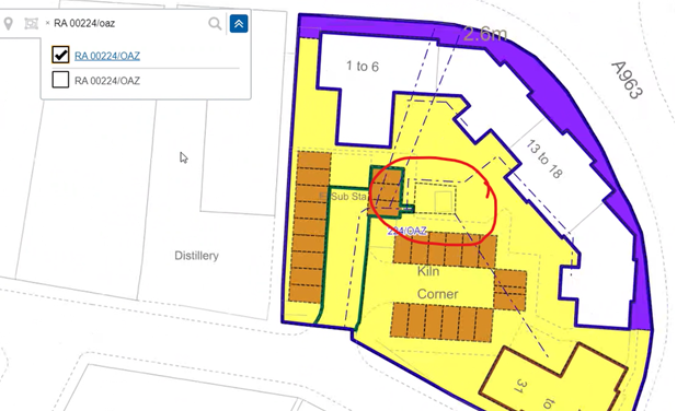
A White polygons will appear as pecked line polygons in Plan Creator.
This means that they will no longer serve their intended purpose of representing holes within larger coloured polygons.
| Note the area circled red on this image - in plan creator, the polygon is NOT shown as a filled white polygon (as it originally was in the DMS). | |
This can be easily fixed in the Plan Creator by creating a hole in the yellow polygon and deleting the extra pecked line polygon used in the DMS version to mimic a hole. See guidance on the Cookie Cutter tool for assistance. Please note, there is no requirement to fix this issue unless required by the case you are working upon. |
B Rendering issues
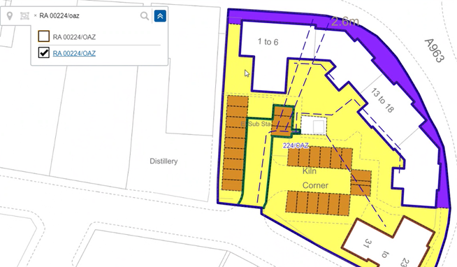
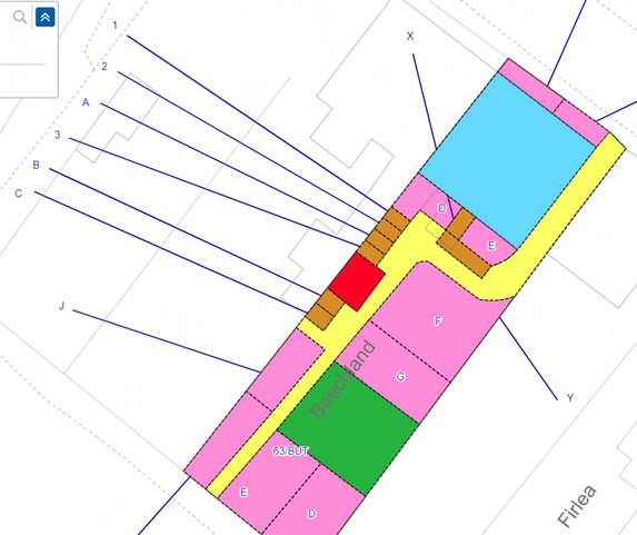
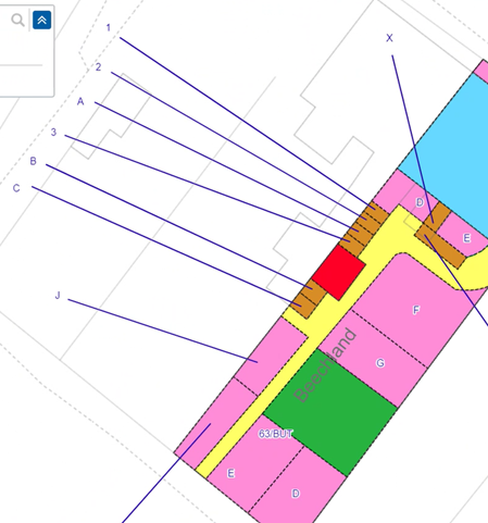
Some rendering (layer ordering) issues from the DMS have been carried forward to the Plan Creator. This will result in some references being obscured.
The 2 images below show the ends of the arrow references disappearing under the tinted areas. This is a temporary issue and will be resolved in due course by a further Plan Creator update.
Registers of Scotland (RoS) seeks to ensure that the information published in the 2012 Act Registration Manual is up to date and accurate but it may be amended from time to time.
The Manual is an internal document intended for RoS staff only. The information in the Manual does not constitute legal or professional advice and RoS cannot accept any liability for actions arising from its use.
Using this website requires you to accept cookies. More information on cookies.
Feedback
