How the Edge Stacker Works
The first point to note is that the Edge Stacking tool is an automated function and isn't selected by using a button in the toolbar.
The second point to note is that the Edge Stacking tool is only applied to the pdf file/print that can be generated within the Plan Creator & UWV, but does not apply when viewing the cadastral map as a whole in those systems, or when working on a live title within the Plan Creator.
The Edge Stacking Tool allows legacy plans, originally mapped in DMS and imported into Plan Creator with overlapping edged polygons, to be visible when the PDF print is generated, for checking that all references are clear and visible on the cadastral map extract. This allows complex titles with many overlapping edges such as historic LSVT titles or existing large parent titles to retain their mapping style for efficiency of processing applications, and for MUs by Land Register Maintenance to be processed without amending the title sheet.
Legacy DMS title plans
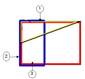
Legacy DMS title plans that contain polygons with flipped edges, or multiple edges with different widths, do not display clearly within the UWV or the Plan Creator as all edge references are shown with the same width and orientation, often obscuring each other. With the introduction of the Edge Stacker tool, these titles will now display differently when viewed through a pdf file/print created in the Plan Creator or UWV. Instead of those edges being flipped, the Edge Stacker function will automatically be applied, and the edges will be stacked with thicker edges sitting under thinner edges, allowing all colours to be seen.
The render ordering of the various coloured edge references will be automatically be re-set using the rendering rules - see Further Guidance page Render Order in the Plan Creator for full details.
Live applications in Plan Creator
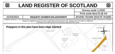
If you are working on a live application that means you have to open a version of a DMS legacy title in the Plan Creator, you should check to see if there are any instances of flipped or multiple edges within that title. You can do this by using the Save & Print PDF tool in the Plan Creator to generate and download a copy of the pdf. When the pdf file is opened, you will see text that has been added in the top left hand corner to alert you to the fact that edge stacking has been automatically applied (please note this text is only displayed on the draft pdf plan and will not appear on the final title plan once it has been approved).
This wording will appear on draft pdf plans for the primary layer of ungrouped references or any groupings in which edge stacking has been applied. It will not appear on draft pdf plans for the primary layer of ungrouped references or any groupings in which edge stacking has not been required.
The wording will appear on the first page of any draft pdf plan only.
If the above warning text appears when you check the draft pdf print for your title, and you do not think there are edge stacked polygons in the title, it would suggest a very small error in geometry causing an overlap between polygons, possible caused by poor plotting of polygons brought forward from an earlier DMS title.
You should try to identify and resolve the issue before approving the title. If it is a large title and the edge stacking issue cannot be found, raise a ticket through RosNOW for Mapping Domain to look at the code behind the title to identify the issue to allow you to resolve this.
Live applications pending approval in Plan Approval
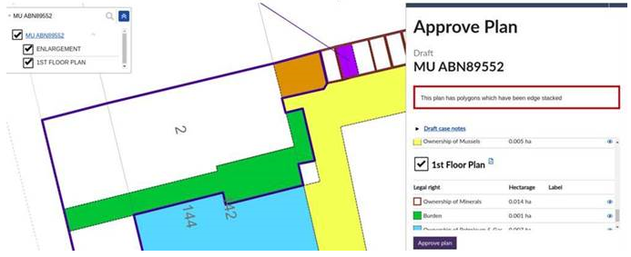
When considering whether to approve a plan in the Plan Approver, a message will be displayed at the top of the right hand panel to alert you to the fact that edge stacking has been automatically applied to the plan.
When the edge stacking message appears, you will see that a PDF icon is displayed next to the primary ungrouped layer and/or the groupings that are affected by the edge stacking function. Clicking on this pdf icon will allow you to download a copy of the draft pdf plan to view how the edges have been stacked.
If you are unsure whether it is appropriate to approve a particular plan with stacked edges (perhaps where you think making different use of tints and hatches, or groupings, would be more appropriate), speak to your referral officer in the first instance.
When is it appropriate to make use of the Edge Stacking functionality?
- The edge stacking functionality is not to be made use of when mapping new applications in the Plan Creator. No new titles mapped in the Plan Creator should be mapped with overlapping edges, and it should be noted that to do so will result in a Quality Check fail. If your title is complex, Groupings should be used as additional cadastral map layers to clearly show all necessary plans references.
- The edge stacking functionality is not to be made use of for smaller titles originally mapped in the DMS with only a few references but that happen to have overlapping edges. The title references should be re-considered to ensure all are visible, making use of Groupings if required as additional cadastral map layers to clearly show all necessary plans references. A Further Guidance page on Updating existing DMS titles in the Plan Creator will help you with suggestions on how to re-work a title like this.
- The edge stacking functionality is not to be made use of when mapping new developments. Removals should be positively removed from the parent title, with the cadastral unit and deed of conditions references, etc being constructed using Groupings as additional cadastral map layers where necessary.
- The edge stacking functionality can be used with existing parent titles originally mapped in the DMS, however consideration should be given to whether the title can be remapped positively to improve the legibility of the cadastral map, or whether the existing references can be changed to eliminate edge stacking while retaining the existing removal style.
- The edge stacking functionality can be used for large parent titles or LSVT titles originally mapped in the DMS which have multiple overlapping edged polygons, and which would be very time consuming to remap just now.
If you are unsure whether it is appropriate to make use of the edge stacking functionality with a particular title, speak to your Plan Creator business lead or referral officer.


