When to Map Areas of Exclusive and Common Ownership, and Other Pertinents
Requirements for FR and TP applications within tenements
There are two fundamental requirements that must be met before the Keeper will proceed any further with an application to register a flat or unit in a tenement steading. These are:
- Tenement steading extent. if the Keeper does not already hold an acceptable extent for the tenement steading, either (1) a plan or suitable description of the extent of the full tenement steading cadastral unit, or (2) a plan or suitable description of the tenement building itself, and of all the rights and pertinents of the flat that are located outwith the building must be supplied in the application - See Further Guidance on acceptable deed plans, bounding descriptions and identifying the tenement steading extent; and
- Unique flat description. A plan or suitable description of the individual flat that allows the flat to be differentiated from all other flats in the building must be supplied with the application - see Further Guidance on acceptable descriptions of flatted property.
If either of these two requirements is not met, the application should be considered for rejection as the application does not comply with the conditions of registration.
Once it has been established that these two requirements are met, further consideration can then be given to the particulars of the application and how it should be plans settled.
When to provide a plans reference for an area of exclusive or common ownership, and other pertinents in a tenement steading?
In simple terms, the guidelines are:
- If it's shown on a deed plan or has a full bounding description, and can be mapped - map it;
- If it's shown on a deed plan or has a full bounding description, but can't be mapped - consider it for rejection;
- If it's described verbally, see Further Guidance page When to Accept Verbal Descriptions.
Examples
| Scenario | Action to take |
|---|---|
| The extent and location of the flat is shown on an acceptable deed plan. | Map it in a grouping showing supplementary data. Classify the flat reference as Ownership - Strata. |
| The extent and location of the flat is shown on an acceptable deed plan and is spread over multiple floor levels. | Map it in one or more groupings showing supplementary data, using several groupings if necessary for the floor levels (name them supplementary data 1, supplementary data 2, and so on, using the number of the relevant grouping). Classify the flat references as Ownership - Strata. See example, below. |
| The extent and location of an area of exclusive ground outwith the building but within the tenement steading is shown on an acceptable deed plan. | Map it in a grouping showing supplementary data. Classify the reference as Ownership - Exclusive. |
| The extent and location of an area of exclusive ground outwith the building but within the tenement steading is described with an acceptable full bounding description. | Map it in a grouping showing supplementary data. Classify the reference as Ownership - Exclusive. |
| The extent and location of an area of commonly-owned ground outwith the building but within the tenement steading is shown on an acceptable deed plan. | Map it in a grouping showing supplementary data. Classify the reference as Ownership - Shared. |
| The extent and location of an area of commonly-owned ground outwith the building but within the tenement steading is described with an acceptable full bounding description. | Map it in a grouping showing supplementary data. Classify the reference as Ownership - Shared. |
| The extent and location of an exclusive pertinent to the flat on a particular floor is shown on an acceptable deed plan. | Map it in a grouping showing supplementary data. Classify the reference as Ownership - Strata. |
| The extent and location of a shared pertinent, such as a bike cupboard or shared cellar on a particular floor of the tenement building is shown on an acceptable deed plan. | Map it in a grouping showing supplementary data. Classify the reference as Ownership - Shared. |
| The extent and location of a shared pertinent, such as a wash-house or coal cellar, outwith the building but within the tenement steading is shown on an acceptable deed plan. | Map it in a grouping showing supplementary data. Classify the reference as Ownership - Shared. |
When to use multiple groupings
There will be properties where the flat or unit and the pertinents conveyed with the flat or unit will have overlapping extents on different floor levels within the tenement. When the situation is straightforward and there are no small references needed, it may be possible to use a single grouping for references on different floors. However, when the situation is complex or some of the references are small, it won't be possible to plot and classify these clearly in a single grouping. Instead two or more groupings should be use to separate out these references so that they are clearly displayed and easily understood.
| Example 1 | |
|---|---|
The property is described in the deed as being the first floor flat edged red on the deed plan together with a right in common to the ground floor passage coloured yellow. Normal settle practice for flats would be to tint or edge the flat reference in blue - see the Mapping Styles guidance page for additional information. Due to the narrowness of the portion of flat jutting out over the passage, you should consider that even at 1:1,250 base scale using a tint and edge reference will result in some detail being obscured. Even if a hatch is used, the extent of the two references would not be clear. Therefore, in a scenario like this, the references for the flat, etc should be split into two groupings. | 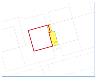 |
| A grouping containing supplementary data 1 should be set up for the Ownership - Strata reference on the first floor. |  |
| A second grouping containing supplementary data 2 should be set up for the Ownership - Shared reference on the ground floor. | 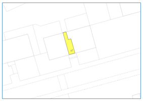 |
| Any other references required for pertinents should be put on the most appropriate grouping. | |
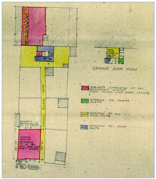
| Example 2 | |
|---|---|
The property is described in the deed as being the first floor flat coloured pink on the deed plan together with the coal cellar coloured pink on the first floor landing, and the garden ground coloured pink. A right in common is narrated to the common access hatched yellow, and the common yard and mutual pathway coloured yellow. No mention in the deed of the areas coloured blue and green. Since in this example, the exclusive floor level references of the flat and coal cellar will overlap with the shared ownership references for the common access and yard, it is preferable to split the references into two groupings to make classification simpler and the references clearer to see. |
|
| A grouping containing supplementary data 1 should be set up for the Ownership - Strata references on the first floor. | 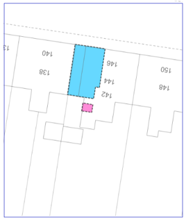 |
| A second grouping containing supplementary data 2 should be set up for the Ownership - Shared references on the ground floor as well as the Ownership - Exclusive reference for the area of garden ground to the rear. | 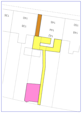 |
| Any other references required for pertinents should be put on the most appropriate grouping. | |
There is a useful rule of thumb with regard to descriptions of parts of tenements and deciding whether a competition in title exists. Sometimes, from different floor level plans in our title or between titles, it can appear at first glance as if two references compete - for instance, a third floor flat and the common stairwell. However, as well as looking at the extent shown on the plan and taking account of any stated floor levels in the deed, we should also take into account the verbal description itself.
So if something is described as a common stairwell, then that verbal description acts to restrict the extent to only the part of the building occupied by the common stairwell. So even when the reference of the third floor flat appears to extend into or over the reference for the common stairwell, there is no competition. The flat is the part or slice of the tenement building occupied by the flat, and the common stairwell is the part or slice of the tenement occupied by the common stairwell. To avoid confusion, it is often best to show such "overlapping" references in different groupings (see examples 1 and 2, above).
If you are in any doubt about whether apparently overlapping references within a tenement are in competition or not, please speak with your referral officer.
Registers of Scotland (RoS) seeks to ensure that the information published in the 2012 Act Registration Manual is up to date and accurate but it may be amended from time to time.
The Manual is an internal document intended for RoS staff only. The information in the Manual does not constitute legal or professional advice and RoS cannot accept any liability for actions arising from its use.
Using this website requires you to accept cookies. More information on cookies.
Feedback