Bounding Description of Property Must Be Acceptable

General 

A key requirement for registration in the Land Register is that applications must provide a satisfactory description of the property to allow the Keeper to accurately represent that property on the cadastral map. See Description of Property Must Be Acceptable for details of the requirements for different application types.

Prior to the introduction of the Land Register, there was no requirement for title deeds that were recorded in the Register of Sasines to include an accurate plan of the property. Instead, the requirement was that to record a deed it must contain a sufficient description of the property. Such descriptions are varied and can include plans drawn by professional surveyors, plans drawn by non-professionals, plans based on historic maps, boundary descriptions based on physical features, descriptions based on field numbers, descriptions based on vague descriptions, or a combination of these. As the quality of the description or plan in these prior Sasine deeds is not always suitable for registration purposes, sometimes it is necessary for a new deed plan to be produced to clarify the historical descriptions contained in the prior deeds. Such new deed plans should be attached to the DIR in the application and are not acceptable as standalone "certified plans".


Bounding descriptions

When the deed for extent describes the property without reference to a plan, the cadastral unit may be mapped from this description only when it is unambiguous and clearly identifiable.


 click here for guidance on accepting bounding descriptions

Essential criteria for previously recorded or registered deeds for extent containing bounding descriptions

If all of the three criteria listed below are met, the bounding description is known as a full bounding description and is acceptable.


CriteriaAdditional Comments
1Every boundary of the property must be clearly described.This must include a reference to the compass orientation, and may include a description of the adjoining property (e.g. on the west by the high road to Largs) as well as a description of the boundary itself (e.g. following the line of a stone wall). It may be necessary to look at County Series maps for confirmation of the position of the property if the description is based on older boundary features that have changed over time.
2Every boundary must include a dimension.Measurements given in previously recorded deeds may be given in metric or imperial units.
3The location of the property, as well as the extent, must be clearly described.This could be a postal address, or by giving a measurement to the starting point from another known point (e.g. 50 ft west of the east wall of the cemetery).
 Examples of acceptable and unacceptable bounding descriptions

"All and Whole that piece of ground extending to 398 decimal or thousandth part of an acre or thereby, which piece of ground is bounded as follows; on the south by the road or street leading from Main Street to Millside; on the east by ground disponed by James Townsend to John Kay; on the north by ground disponed by the said James Townsend to Alexander Beveridge; and on the west by a lane."

"All and Whole that plot of ground situated on the west side of Wallace Street, Perth bounded as follows; on the north by the centre line of a mutual division wall between the subjects and 8 Wallace Street along which it extends seventy one feet eight inches or thereby; on the east by Wallace Street along which it extends thirty one feet three inches or thereby; on the south by the centre line of a mutual division wall between the subjects and 12 Wallace Street along which it extends seventy six feet or thereby: on the west by the outer face of a wall along which it extends thirty one feet three inches or thereby."

"All and Whole that plot or area of ground extending to twenty six decimal or one thousand parts of a hectare or thereby in the Parish of Grangemouth and County of Stirling known as and forming number Twenty Killin Drive, Polmont, Stirlingshire and bounded as follows:- on or towards the north north east by a footpath along which it extends ten metres and twenty centimetres or thereby; on or towards the east south east by other subjects known as and forming number twenty two Killin Drive along which it extends twenty nine metres or thereby, the boundary being the centre line of a mutual rear division fence and projection thereof; on or towards the south south west by a footpath along which it extends ten metres and twenty centimetres or thereby: and on or towards the west north west by other subjects known as and forming number 18 Killin Drive, along which it extends twenty eight metres and fifty centimetres or thereby, the boundary being the centre line of a mutual rear division fence, the centre line of a mutual internal division wall and projection thereof."

Example 1 - unacceptable bounding description

Example 2 - acceptable full bounding description

Example 3 - acceptable full bounding description


This bounding description meets some but not all of the criteria for accurately identifying a property on the cadastral map, and therefore cannot be accepted for registration. Although it contains a brief description of each boundary and refers to their compass direction, only two of those are physical features (the road & the lane) making it harder to establish the shape of the property. Also, no dimensions are given for any of the boundaries. Therefore it does not contain sufficient information to identify the property accurately on the cadastral map.

This style of description is often referred to as a Common Law description and is often found in older rural or small town properties.


This full bounding description meets all of the criteria for accurately identifying a property on the cadastral map, and therefore can be accepted for registration. All four boundaries are clearly described & refer to compass directions, dimensions are given for all boundaries (the measurements are given in feet & inches but these are acceptable if contained in previously recorded deeds), and the location of the property can be found by the reference to the two adjoining postal addresses.


This full bounding description meets all of the criteria for accurately identifying a property on the cadastral map, and therefore can be accepted for registration. All four boundaries are clearly described & refer to compass directions, dimensions are given for all boundaries, and the location of the property can be found by the reference to the given postal address.

Guidance

If the bounding description contained in a previously recorded or registered deed for extent in your application does not meet the three criteria listed above, refer to a referral officer as the application may need to be rejected because the Keeper cannot accurately identify and represent the property on the cadastral map.


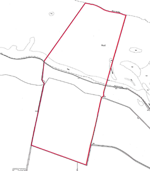
Bounding descriptions submitted to define the extent of a tenement steading

 click here for guidance on accepting bounding descriptions of tenement steadings

If the property to be registered is a flat or unit within a tenement, flatted or other sub-divided building, the Keeper will represent that tenement and all registered flats within it as a single cadastral unit on the cadastral map. Where possible, the tenement steading cadastral unit will comprise the extent of all flats, their rights and pertinents. If this is not possible, provided certain requirements are met, a restricted extent can be set up comprising the extent of all registered flats, their rights and pertinents; if a restricted extent is used, it may be updated by the keeper to include any additional areas of ground registered as part of future applications to register further flats in the same tenement.

Often, the Keeper will already hold an acceptable extent for the tenement steading. However, there will also be instances when the Keeper does not already hold an acceptable extent for the tenement steading. In such instances, either (1) a plan or suitable description of the extent of the full tenement steading cadastral unit, or (2) a plan or suitable description of the tenement building itself, and of all the rights and pertinents of the flat that are located outwith the building must be supplied in the application otherwise the application will be rejected -  See Further Guidance on acceptable deed plans, bounding descriptions and identifying the tenement steading extent;

The tenement steading provided in the application can be:

  • shown on a new deed plan attached to the DIR;
  • by inclusion in the application as a separate plan; this plan may be referred to in the application form although it is not essential for the application form to include the reference;
  • shown on a previously recorded or registered deed plan; or
  • a verbal or bounding description contained in a previously recorded or registered deed.


Guidance

If the steading is shown on a deed plan, the criteria listed above for new deed plans and previously recorded or registered deed plans should be met and the same guidance followed.


Bounding description used in combination with a verbal description of the foreshore "ex adverso" the subjects
 

 click here for guidance on accepting descriptions of foreshore "ex adverso" the subjects on a deed plan

A style of property description occasionally seen is for the plot of land to be described by a full bounding description of the land above the high water mark and then to be supplemented by a verbal description of the foreshore ex adverso the described plot of land. By using the term ex adverso, the description is limiting the lateral boundaries to those at the extremes of the landward boundaries; and by using the term foreshore, the description is limiting the landward and seaward boundaries to the high and low water marks, respectively. This is an acceptable style provided:

  • it is clear from the verbal description which boundary is being referred to;
  • the plot described in the bounding description extends to the high water mark; and
  • it is the whole foreshore (from the high to the low water) that is included in the description, not just an undefined part of it.

The extent of the foreshore described in the deed should be included within the mapping of the cadastral unit: a separate reference for the foreshore will only be required if legal advise that a reference is required for burdens, etc. When plotting the foreshore, the seaward boundary is the mean low water mark of ordinary spring tides (the line of which is marked "MLWS" on the OS map). The lateral boundary of the section of foreshore is a line drawn seawards from the end of the land boundary, perpendicular to a straight line drawn parallel to the average direction of the coast. See Mapping Natural Water Boundaries for more guidance on water boundaries in general.


 Acceptable & unacceptable examples

Unacceptable combinations of bounding description and "ex adverso" descriptionAcceptable combination of bounding description and "ex adverso" description

Description in deed

  • "All & whole...[the bounding description of the land above the high water mark], together with the foreshore...."
    (the extent of the foreshore to be included is not specified in the description - from this description, the lateral boundaries are not defined)

  • "All & whole...[the bounding description of the land above the high water mark], together with part of the foreshore ex adverso the subjects...."
    (the part of foreshore to be included is not specified)

  • "All & whole...[the bounding description of the land above the high water mark], together with part of the foreshore ex adverso the north boundary...."
    (the part of foreshore to be included is not specified)
  • "All & whole...[the bounding description of the land above the high water mark], together with the foreshore ex adverso the north boundary...."

  • "All & whole...[the bounding description of the land above the high water mark], together with the foreshore ex adverso the subjects...."
    (although a particular boundary has not been specified, if it is clear from the full bounding description which boundary follows the high water mark, then the location of the area of foreshore can be identified. Therefore it is ok to accept this description)

Action to be taken

As none of the example descriptions given, above, contain an acceptable description of the area of foreshore to be included within the cadastral unit, the application should be rejected.

As each of these example descriptions are acceptable and identify the full extent of the foreshore being registered, the cadastral unit should be mapped to its full extent.

The lateral boundaries are plotted at right angles to the average line of the high water mark at that point on the coast.

Cadastral unit extent


Guidance

If it is not clear from the deed exactly which area of foreshore is to be included in the cadastral unit, then the application should be rejected as an acceptable description of the whole plot of land to be registered has not been provided in the application.


Registers of Scotland (RoS) seeks to ensure that the information published in the 2012 Act Registration Manual is up to date and accurate but it may be amended from time to time.
The Manual is an internal document intended for RoS staff only. The information in the Manual does not constitute legal or professional advice and RoS cannot accept any liability for actions arising from its use.
Using this website requires you to accept cookies. More information on cookies.
Feedback