Deed Plan Must Be Acceptable
- Admin1 (Unlicensed)
- Editor9
When there DIR describes the extent of the property to be registered by reference to both a new plan annexed to the DIR and to a previously recorded deed, the extent is to be taken from the new plan annexed to the DIR.
Demonstrative Deed Plans - It is the Keeper's published policy that new deed plans "must not be stated to be demonstrative only and not taxative". While there are relatively few DIRs which contain this statement, or similar, if your application does contain such a statement, it should be referred to a referral officer for rejection.
New deed plans
Essential criteria for new deed plans
If all of the five criteria listed below are met, the new deed plan is acceptable.
| Criteria | Additional Comments | |
|---|---|---|
| 1 | The scale of the deed plan must be appropriate to the scale of the Ordnance Survey (OS) map, or other base map used by the Keeper. | If the scale of the most suitable available map is insufficient to show all the necessary detail, an inset plan at a larger scale may be used. |
| 2 | A scale and the orientation of north must be displayed on the deed plan. | A drawn or bar scale is preferred as this allows any distortion from photocopying or re-printing to be identified. |
| 3 | The deed plan must contain sufficient surrounding detail to enable the position of the subjects to be fixed with accuracy. | Useful surrounding detail includes features such as fences, other buildings, and road junctions. |
| 4 | The boundaries of the subjects must be clearly shown, preferably with measurements. | The plan must not be stated to be demonstrative only and not taxative; measurements on new plans should be shown in metric units. |
| 5 | References on the deed plan must be clearly identifiable. | Exclusive and shared areas must be referenced separately on the deed plan, and should be consistent with the text of the deed. |
View the full guide published by the Keeper for conveyancers and other legal professionals on Deed Plan Criteria
|
| 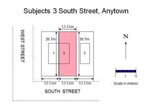 |
Figure 1 - unacceptable deed plan | Figure 2 - extract from OS map | Figure 3 - acceptable deed plan |
This deed plan meets some but not all of the criteria for accurately identifying a property on the cadastral map, and therefore cannot be accepted for registration. Although it is at an appropriate scale, is drawn to scale, has a north arrow, and contains a single metric measurements, it does not contain sufficient surrounding detail to identify it accurately on the cadastral map. This particular style of deed plan is often known as a floating shape plan. | The subjects shown on the plan in Figure 1 could be any of the three properties coloured on this extract from the OS map. Lorem ipsum dolor sit amet, consectetur adipiscing elit. Aliquam dictum ex hendrerit suscipit sollicitudin. Pellentesque efficitur id lorem id eleifend. Lorem ipsum dolor sit amet, consectetur adipiscing elit. Aliquam dictum ex hendrerit suscipit sollicitudin. Pellentesque efficitur id lorem id eleifend. | This deed plan meets the criteria for accurately identifying a property on the cadastral map and can therefore be accepted for registration. It is at an appropriate scale, is drawn to scale, has a north arrow, contains metric measurements, and contains sufficient surrounding detail to identify it accurately as the property coloured pink on Figure 2. |
If the new deed plan in your application does not meet the five criteria listed above, refer to a referral officer as the application may need to be rejected because the Keeper cannot accurately identify and represent the property on the cadastral map.
Previously recorded or registered deed plans
Essential criteria for previously recorded or registered deed plans
If all of the five criteria listed below are met, the previously recorded or registered deed plan is acceptable.
| Criteria | Additional Comments | |
|---|---|---|
| 1 | The scale of the deed plan must be appropriate to the scale of the Ordnance Survey (OS) map, or other base map used by the Keeper. | If the scale of the most suitable available map is insufficient to show all the necessary detail, an inset plan at a larger scale may be used. |
| 2 | A scale and the orientation of north must be displayed on the deed plan. | As paper plans may have distorted over time, do not rely on a stated scale (e.g. 1:2,000); instead use a bar scale if shown or consider georeferencing the deed plan in QGis. |
| 3 | The deed plan must contain sufficient surrounding detail to enable the position of the subjects to be fixed with accuracy. | It may be necessary to look at County Series maps for confirmation of the position of the property if the deed plan is based on an older map or shows surrounding features that have changed over time. |
| 4 | The boundaries of the subjects must be clearly shown, preferably with measurements. | Measurements on previously recorded or registered deed plans may be shown in metric or imperial units. |
| 5 | References on the deed plan must be clearly identifiable. | Exclusive and shared areas must be referenced separately on the deed plan, and should be consistent with the text of the deed. If only a copy of the original deed plan is submitted, the references must be legible on the copy; in particular, if a monochrome copy of a coloured plan is submitted, the plan is only acceptable if all the references can be clearly distinguished (for example, from different hatchings on the plan, or by use of any textual information on the plan). |
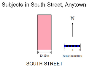 | 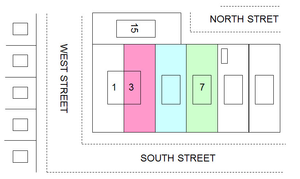 | |
Figure 1 - unacceptable deed plan | Figure 2 - extract from OS map | Figure 3 - acceptable deed plan |
This deed plan meets some but not all of the criteria for accurately identifying a property on the cadastral map, and therefore cannot be accepted for registration. Although it is at an appropriate scale, is drawn to scale, has a north arrow, and contains a single metric measurements, it does not contain sufficient surrounding detail to identify it accurately on the cadastral map. This particular style of deed plan is often know as a "Floating Shape" plan. | The subjects shown on the plan in Figure 1 could be any of the three properties coloured on this extract from the OS map. Lorem ipsum dolor sit amet, consectetur adipiscing elit. Aliquam dictum ex hendrerit suscipit sollicitudin. Pellentesque efficitur id lorem id eleifend. Lorem ipsum dolor sit amet, consectetur adipiscing elit. Aliquam dictum ex hendrerit suscipit sollicitudin. Pellentesque efficitur id lorem id eleifend. | This deed plan meets the criteria for accurately identifying a property on the cadastral map and can therefore be accepted for registration. It is at an appropriate scale, is drawn to scale, has a north arrow, contains metric measurements, and contains sufficient surrounding detail to identify it accurately as the property coloured pink on Figure 2. |
If the previously recorded or registered deed plan in your application does not meet the five criteria listed above, refer to a referral officer as the application may need to be rejected because the Keeper cannot accurately identify and represent the property on the cadastral map.
Deed plans submitted to define the extent of a tenement steading
Deed plans used in combination with a verbal description of the foreshore "ex adverso" the subjects shown on the deed plan
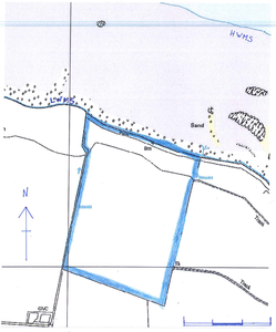
A style of property description occasionally seen is for the plot of land to be described by reference to a deed plan and then to be supplemented by a verbal description of the foreshore ex adverso the defined plot of land. By using the term ex adverso, the description is limiting the lateral boundaries to those at the extremes of the landward boundaries; and by using the term foreshore, the description is limiting the landward and seaward boundaries to the high and low water marks, respectively. This is an acceptable style provided:
- it is clear from the verbal description which boundary is being referred to;
- the plot shown on the deed plan extends to the high water mark; and
- it is the whole foreshore (from the high to the low water) that is included in the description, not just an undefined part of it.
The extent of the foreshore described in the deed should be included within the mapping of the cadastral unit: a separate reference for the foreshore will only be required if legal advise that a reference is required for burdens, etc. When plotting the foreshore, the seaward boundary is the mean low water mark of ordinary spring tides (the line of which is marked "MLWS" on the OS map). The lateral boundary of the section of foreshore is a line drawn seawards from the end of the land boundary, perpendicular to a straight line drawn parallel to the average direction of the coast. See Mapping Natural Water Boundaries for more guidance on water boundaries in general.
| Unacceptable combinations of plan and "ex adverso" description | Acceptable combination of plan and "ex adverso" description | |
|---|---|---|
Deed Plan | ||
Description in deed |
|
|
Action to be taken | As none of the example descriptions given, above, contain an acceptable description of the area of foreshore to be included within the cadastral unit, the application should be rejected. | As each of these example descriptions are acceptable and identify the full extent of the foreshore being registered, the cadastral unit should be mapped to its full extent. The lateral boundaries are plotted at right angles to the average line of the high water mark at that point on the coast. |
Cadastral unit extent |
|
If it is not clear from the deed exactly which area of foreshore is to be included in the cadastral unit, then the application should be rejected as an acceptable description of the whole plot of land to be registered has not been provided in the application.
Previously recorded or registered deeds with plans and referring to parcel or field numbers
Exceptions
1 Property is seabed
If your application is to register an area of seabed in the registration county of SEA, special requirements exist. See Further Guidance Description of Seabed Plot Must Be Acceptable.
2 Lease of part of a tenement
If your application is to register a lease of part of a tenement, there is an exception to the normal policy that can be applied if the lease contains a verbal description AND refers to a plan. If the plan showing the leased premises does not meet the keeper’s requirements for mapping, we can treat the reference to the plan as pro non scripto and work solely with the verbal description of the leased premises. This is only possible because of the keeper’s policy of incorporating the whole of the lease deed (with any plans) into the title sheet by reference to the deed in the archive record, since the information contained in the lease plans is not “lost” when the keeper uses only the verbal description. This exception to normal policy must only be applied to this scenario of leases within tenements (and an associated APR application) – not to non-tenement leases, and not to ownership titles within tenements.
It must be stressed, however, that the keeper can only proceed on the basis of the verbal description if that verbal description is acceptable. The external general guidance on the cadastral map relating to tenements and other flatted buildings states that where the keeper already holds an extent for the tenement steading, the applicant should ensure that that their application/deed is clear about the location [within the tenement] of the flat or unit with which they are dealing. See Further Guidance page Description of Flatted Property Must Be Acceptable for details of what constitutes an acceptable verbal description.
3 Lease plans showing detail other than the extent of the leased premises
Often in a lease, or variation of lease, as well as the plan showing the extent of the leased premises, there will be additional plans annexed to the deed that show leasehold conditions (for example, rights of access in favour of the tenant, extent of the landlord's larger subjects, etc). As the keeper will only be mapping the extent of the leased premises, and will not be providing plans references for the leasehold conditions (see Mapping Leases for guidance on the keeper's policy on preparing lease title sheets), there is no requirement for those additional plans to meet the deed plan criteria set out, above.
4 Voluntary registration
It is acceptable for a voluntary registration application to use digital data as an alternative to paper based plans and deeds. With voluntary registrations the application may or may not include the paper deeds or they may not contain sufficient information to identify the location and extent of the property. In this scenario, the submitting agent may choose to submit plans information in digital format. In this case, a PDF of the plan is also required. The extent of the subjects can be mapped using the digital data along with the PDF for visual representation. The PDF is essential to ensure that the digital data accurately represents the property being registered.
Registers of Scotland (RoS) seeks to ensure that the information published in the 2012 Act Registration Manual is up to date and accurate but it may be amended from time to time.
The Manual is an internal document intended for RoS staff only. The information in the Manual does not constitute legal or professional advice and RoS cannot accept any liability for actions arising from its use.
Using this website requires you to accept cookies. More information on cookies.
Feedback