This is the registration manual for 1979 casework.
Do not under any circumstances use the information here when settling 2012 casework. This resource has been archived and is no longer being updated. As such, it contains many broken links. Much of the information contained here is obsolete or superseded.
P19 A Guide to P16 Answers
- Former user (Deleted)
- Admin2 (Unlicensed)
19.2 - P16 Answers
This section provides the full answer given in the P16 report however it should be noted the answer may have been adapted where the situation arises.
Revised P16 Answers - Answer 1's
1. The subjects are not identifiable on the Ordnance Survey map.
1A. The P16 Report submitted by you,
does not have a plan or full bounding description with measurements.*
cannot be identified in relation to the Ordnance Survey map.*Please relodge to enable the report to be completed with
an appropriate plan or full bounding description*
a location plan*
1B. P16 Reports cannot be completed for individual tenement or flatted properties.
1C. The current edition of the Ordnance Survey (OS) map held by the Keeper does not show the boundaries of,
the property as depicted on the plan submitted by you.*
the development of which it forms part.*
that part of the development of which it forms part.*Therefore a P16 Report cannot be completed.
Note, if the property is / part of a new development you should inform the Keeper on submission of an application for registration of the current status of work on site, i.e. fully completed, partially built or not started. You should also note the approximate completion date for your subjects and the remainder of the development if applicable.
If the OS have not published an updated map depicting the subjects by the time an application is received. The Keeper will requisition a site survey to pick-up the new detail. In the meantime it is advised that you compare the title deeds with any development on the ground to ensure that any discrepancies between the legal title as shown by the plan and the as built position are identified prior to submitting an application for registration.
1D. The plan / description submitted by you does not allow the Keeper to identify the boundaries of the subjects in relation to the Ordnance Survey map. Therefore a comparison is not possible.
I refer you to the Registration of Title Practice Book (Second Edition) Chapter 4, in particular sections 4.5, 4.6 & 4.9. In view of the comments therein, you may wish to consider producing a plan for the deed inducing registration that meets the Keeper's deed plan criteria (see Chapter 4, Appendix 1). In addition the Registration of Title Basic Guide, published by the Keeper, is available from our Marketing Department. Both fully explain the Keeper's requirements for such plans.
Revised P16 Answers - Answer 2's
2. The boundaries of the subjects coincide with those on the Ordnance Survey map.
2A. The boundaries between the points ....................... on your plan,*
The boundaries narrated as being .............................in measurement in the description of the subjects,*
are not defined on the Ordnance Survey (OS) map.
This may be as a result of a number of factors :-
no physical feature may exist for the boundaries in question,
the OS map may not reflect the current position of features as they exist on the ground,
boundary features may fall out with the criteria for referencing on the OS map.
However it is not envisaged that there will be any difficulties in respect of the boundaries at registration stage.
2B. The subjects in this report appear to form part of a 'four in a block'* / 'split-villa'* style property. The P16 procedure does not normally cover properties comprising only part of a larger building, and internal garden divisions are rarely shown on the Ordnance Survey (OS) map, unless they are of a substantial nature.
However as the plan submitted by you does show the external boundaries of the steading of which the subjects form part it is possible to complete a P16 Report over those features. In this instance I can confirm that the position of the external boundaries agree with the boundaries as depicted on the OS map.
2C. The P16 procedure does not normally cover individual flats or parts of a tenement.
However, in this instance, it is possible to confirm that the extent of the tenement of which your subjects forms part has already been determined during the course of a previous registration / investigation of the title deeds.
As a consequence no problems should be encountered on First Registration.
2D. The plan submitted with this Report is a 'floating shape'. The plan does not show any or sufficient detail of the area surrounding the subjects, e.g. adjoining houses, fencing, roads, etc. to accurately position the subjects on the Ordnance Survey Map. However by limited scaling the subjects in this Report would appear to agree with the area coloured pink on the attached print.
Note- subjects drawn on a plan referred to as a 'floating shape', can be described as an area of ground that has been drawn in isolation from its surroundings. As a result the area cannot be fixed in the context of its surroundings with any accuracy and may result in remedial work being required at registration stage. The Registration of Title Basic Guide, published by the Keeper, further explains the difficulties with plans that are referred to as 'floating shapes'.
2E. The subjects in this Report appear to comprise a flatted property together with exclusive areas of ground. Please note a P16 Report cannot be completed for that part of the subjects comprising the flat.
However in respect of the exclusive areas of ground the boundaries coincide with those shown on the Ordnance Survey map, so far as defined*.
2F. The plan submitted by you does not contain any measurements for the boundaries, nor does it conform to scale. As a result an accurate comparison between the plan and the Ordnance Survey (OS) map is not possible.
However by limited scaling from the features shown on the plan, the boundaries would appear to agree with those features depicted on the current edition of the OS map.
I refer you to the Registration of Title Practice Book (Second Edition) Chapter 4, in particular sections 4.5, 4.6 & 4.9. In view of the comments therein, you may wish to consider producing a plan for the deed inducing registration that meets the Keeper's deed plan criteria (see Chapter 4, Appendix 1). In addition the Registration of Title Basic Guide, published by the Keeper, is available from our Marketing Department. Both fully explain the Keeper's requirements for such plans.
2G. The subjects shown on the plan submitted by you do not agree with the boundaries shown of the Ordnance Survey (OS) map. However the Keeper has received previous applications in this area* / already investigated the development* and has established that the position of features on the ground does not reflect the extents shown on the deed plans. Given the age and nature of this development the Keeper, as a result of the prior registrations* / earlier investigations*, is willing to register this property as defined on the enclosed extract from the OS map with no exclusion of indemnity regarding the extent.
This P16 Report should be submitted with the application for registration of the property together with confirmation that the extent depicted on the OS map does actually reflect the occupied extent of the subjects.
2H. The plan submitted by you is a copy of the Ordnance Survey map which agrees with the edition of the map held by the Keeper.
Note, if this is a new plan prepared for use with the deed inducing registration, you should satisfy yourself that the subjects depicted thereon accurately reflect the legal title to the property as narrated in the prior title deeds. Failure to reconcile the subjects on the plan with the actual legal extent contained in prior deeds may result in remedial work being required at registration stage.
Revised P16 Answers - Answer 3's
3. The boundaries do not coincide with those shown on the Ordnance Survey Map. Please see print herewith.
3A. The extent of the subjects shown on your plan* / narrated in the description*, have been plotted and tinted pink and blue on the enclosed extract from the Ordnance Survey (OS) map for your assistance. This extent creates an overlap between the subjects and the features depicted on the OS map.
The fenced extent of the subjects as depicted on the current edition of the OS map appears to be as tinted pink on the extract, and the area tinted blue would appear to form part of the adjoining subjects comprising -
Please see the enclosed guidance notes on how to proceed prior to submitting an application for registration.
3B. The extent of the subjects shown on your plan* / narrated in the description*, have been plotted and tinted pink on the enclosed extract from the Ordnance Survey (OS) map for your assistance. This extent creates an shortfall between the subjects and the features depicted on the OS map.
The extent of the subjects as depicted on the current edition of the OS map, appears to include the area tinted blue on the extract, which falls within the defined boundaries of the subjects.
Please see the enclosed guidance notes on how to proceed prior to submitting an application for registration.
3C. The extent of the subjects shown on your plan* / narrated in the description* have been plotted and tinted pink and blue on the enclosed extract from the Ordnance Survey (OS) map for your assistance. This extent creates both an shortfall and an shortfall between the subjects and the features depicted on the OS map.
In respect of the overlap, the fenced extent of the subjects as depicted on the current edition of the OS map appears to be as tinted pink on the extract, and the area tinted blue would appear to form part of the adjoining subjects comprising -
In respect of the shortfall, the extent of the subjects as depicted on the current edition of the OS map appears to include the area tinted yellow on the extract, which falls within the defined boundaries of the subjects.
Please see the enclosed guidance notes on how to proceed prior to submitting an application for registration.
3D. The plan submitted with this Report is a 'floating shape'. The plan does not show any or sufficient detail of the area surrounding the subjects, e.g. adjoining houses, fencing, roads, etc. to accurately position the subjects on the Ordnance Survey (OS) Map. However by limited scaling the subjects in this Report would appear to disagree with the position of the boundaries as shown on the current edition of the OS map.
For your assistance the approximate position of the subjects shown on the plan, have been plotted onto the enclosed extract from the OS map by a red broken line.
Note- subjects drawn on a plan referred to as a 'floating shape' can be described as an area of ground that has been drawn in isolation from its surroundings. As a result the area cannot be fixed in the context of its surroundings with any accuracy and may result in remedial work being required at registration stage. The Registration of Title Basic Guide, available from the Keeper, further explains the difficulties with plans that are referred to as 'floating shapes'.
Please see the enclosed guidance notes on how to proceed prior to submitting an application for registration.
3E. The subjects in this Report appear to comprise a flatted property together with exclusive areas of ground. Please note a P16 Report cannot be completed for that part of the subjects comprising the flat.
However in respect of the exclusive areas of ground the boundaries do not coincide with those shown on the Ordnance Survey (OS) map.
For your assistance the approximate position of the subjects shown on the plan, have been plotted onto the enclosed extract from the OS map by a red broken line.
Please see the enclosed guidance notes on how to proceed prior to submitting an application for registration.
3F. The plan submitted by you does not contain any measurements for the boundaries, nor does it conform to scale. As a result an accurate comparison between the plan and the Ordnance Survey (OS) map is not possible.
However by limited scaling from the features shown on the plan, the boundaries would appear to disagree with those features depicted on the current edition of the OS map. For your assistance the approximate position of the subjects shown on the plan, have been plotted onto the enclosed extract from the OS map by a red broken line.
I refer you to the Registration of Title Practice Book (Second Edition) Chapter 4, in particular sections 4.5, 4.6 & 4.9. In view of the comments therein, you may wish to consider producing a plan for the deed inducing registration that meets the Keeper's deed plan criteria (see Chapter 4, Appendix 1). In addition the Registration of Title Basic Guide, published by the Keeper, is available from our Marketing Department. Both fully explain the Keeper's requirements for such plans.
Please see the enclosed guidance notes on how to proceed prior to submitting an application for registration.
3G. The site that the subjects shown on your plan forms part of, has not been developed on the ground as per the layout depicted on the plan. As a result of the differences between the layout shown on the plan and the position depicted by the Ordnance Survey (OS) map, there is no reliable surrounding detail from which the position of the boundary features of the subjects can be plotted. Therefore it is not possible to establish exactly how the subjects relate to the OS map, and where any discrepancies may fall.
However by picture there does appear to be a discrepancy between the extent shown on the plan and the OS map. For your assistance I enclose an extract from the latest edition of the OS map held by the Keeper.
Please see the enclosed guidance notes on how to proceed prior to submitting an application for registration.
Revised P16 Answers - Additional reply for use in conjunction with Answers 2 & 3.
1. The street numbering shown by the Ordnance Survey (OS) map appears to disagree with the postal address supplied by you. The OS map indicates that the subjects shown on your plan* / in the description* have the following postal address -
The street numbering should be checked prior to any application for registration. Where the OS map appears to be incorrect or out of date, the Keeper should be advised of this as part of any application for registration. The Keeper will then advise the OS of the change.
19.3 Guidance notes for Answer 3 P16 Reports.
The following is the guidance notes and flowchart provided to agents when they receive an answer 3 P16 report.
Guidance Notes for Answer 3 P16 Reports
This P16 Report has received an Answer 3, indicating that the subjects shown on the plan/in the description do not agree with the features on the Ordnance Survey (OS) map.
You are strongly advised to consider any discrepancies prior to submitting an application for First Registration (FR). If you do not investigate a discrepancy highlighted in the report, any subsequent application will be delayed while the Keeper investigates the position.
Note the P16 report is not a check of title and the Keeper cannot provide a definitive answer as to how any discrepancy will be viewed at registration stage, until an application is received and a full examination of title has been completed. However there are several steps you should take prior to submitting an application for registration. Please see flow diagram over.
Qualified P16 Report - Answers 3A, 3B, 3C & 3E.
Note if the P16 Report has received a qualified answer marked 3A, 3B, 3C or 3E. You should follow the step-by-step guide on the reverse of this leaflet. This should enable you to provide the relevant information for the Keeper either, to complete registration, with or without an exclusion of indemnity, or to consider if further investigation/information/remedial work is required.
Qualified P16 Report - Answers 3D, 3F & 3G.
Note if the P16 Report has received a qualified answer marked 3D, 3F or 3G. The Keeper has been unable to produce an accurate report due to the quality and limitations of the plan submitted. The plan fails to meet the Keeper's criteria for deed plans and if submitted with an application for registration, it may not be sufficient for registration purposes and rejected.
Therefore you are advised that if the report has one of these specific answers, you should consider obtaining a new deed plan which fully meets the Keeper's deed plan criteria (see 'The Registration of Title Practice Book', Chapter 4, Appendix 1). Any new deed plan should reflect the occupied extent, but must also coincide with the extent supported by the prior titles deeds (the legal extent) and the extent possessed for the prescriptive period.
Notes - For all answer 3 P16 Reports, the 'First' part of Question 2, must be answered - NO.
(The Keeper examines all applications for registration for reports completed over the subjects. If you answer the question incorrectly the Form 1 will be returned for amendment and completion of the remaining questions.)
In all answer 3 reports, a site visit is recommended to confirm, (1) if the OS map or the title deed plan reflects the actual occupied position on the ground, and (2) the age/nature of features and use/occupation of ground (see below for examples of information required*). The Keeper may seek further evidence of information submitted in connection with an application.
In your response to Question 2 of the Form 1, your attention is also drawn to Question 3 concerning adverse possession and occupation, and Question 14 concerning any facts and circumstances material to the right or title of the applicant.
Deed plans based on copies of previously issued Title Plans will require the provision of supporting evidence to confirm that you hold an appropriate copyright license to use Ordnance Survey (OS) mapping. A licence issued by the OS only covers the map information purchased. Eg. buying a map for an area in Aberdeen does not give a licence to then use any map in Scotland only for any map created from that map originally purchased. I draw your attention to the implications arising therefrom as detailed in paragraph 4.23 of the registration of Title Practice Book (2nd edition)
* Examples of information that should be provided from site visit;
- Age & Nature - post & wire fence 5 years old, wall 50+ years old, hedge 1 year old,
- Use & Occupation - garden ground maintained by No.7 Smith Street, non-maintained grass verge, common washhouse for Nos. 5-7 Smith St., access path used by proprietors of …….. Smith St., etc.
(Neighbouring proprietors may be able to provide additional information in this regard.)
Guidance Notes for Answer 3 P16 Reports
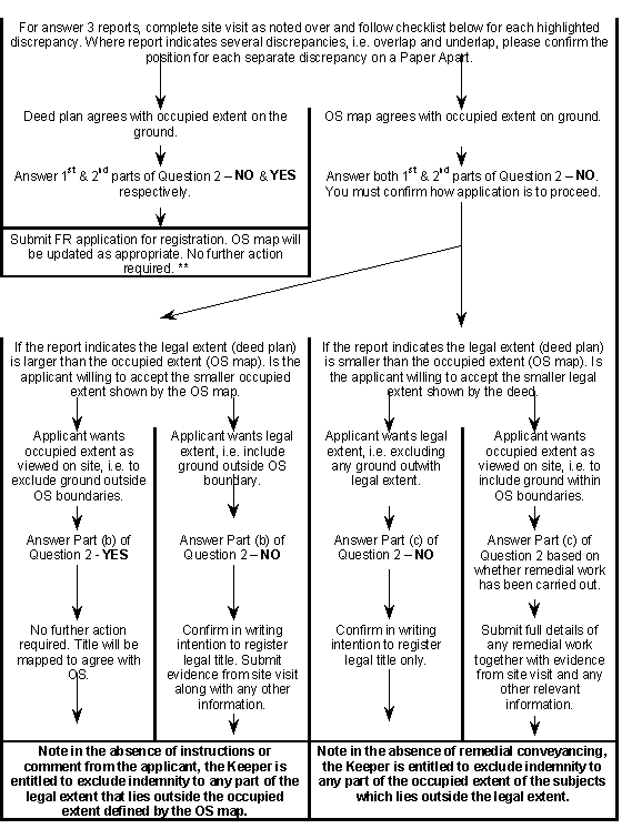
(** Please note when responding to the 2nd part of Question 2 on the Form 1. The Keeper may request a specific site survey of the subjects to update the OS map on the basis of your response to this question. The cost of this survey is met by the Keeper. However if on completion of the survey, the existing OS map is found to be correct and does reflect the position on the ground, i.e. this question has been answered incorrectly. The Keeper reserves the right to seek reimbursement for the survey costs.)
Related content
*
This is the registration manual for 1979 casework.
Do not under any circumstances use the information here when settling 2012 casework. This resource has been archived and is no longer being updated. As such, it contains many broken links. Much of the information contained here is obsolete or superseded.
*
The Manual is an internal document intended for RoS staff only. The information in the Manual does not constitute legal or professional advice and RoS cannot accept any liability for actions arising from its use.
Using this website requires you to accept cookies. More information on cookies.