Tenement Scenarios
- Editor9
- RPT Admin (Unlicensed)
| Section A | Tenement applications with all rights and pertinents within the tenement steading extent |
| Section B | Tenement applications with some rights or pertinents outwith the tenement steading extent as they are owned in common with other tenements or houses |
| Section C | Tenement applications where a restricted tenement steading cadastral unit is to be set up |
| Section D | Tenement applications for a flat or unit in one tenement block with a parking space or garage located in another tenement block |
A - Tenement applications with all rights and pertinents within the tenement steading extent
Scenario 1 - no existing 1979 Act or 2012 Act PRs, the current application does not define the tenement steading extent, and all references in the deed for extent are verbal.
Scenario 2 - no existing 1979 Act or 2012 Act PRs, the current application defines the tenement steading extent, and all rights & pertinents of the flat in the current application are within the tenement steading.
Scenario 3 - existing 1979 Act PR that has been mapped tinting method, but the current 2012 Act application defines the tenement steading, and all rights & pertinents of the flat in the current application are within the tenement steading.
 |  |
| 1979 Act PR mapped tinting method | Current application includes either a plan or a full bounding description of the tenement steading that allows the tenement steading cadastral unit to be mapped. |
Scenario 4 - existing 2012 Act PR that has already set up a tenement steading cadastral unit, and all rights & pertinents of the flat in the current application are within the tenement steading.
Scenario 5 - existing 1979 Act PR that has been mapped site plan method, and all rights & pertinents of the flat in the current application are within the tenement steading.
Scenario 6 - no existing 1979 Act PR that has been mapped site plan method, but there is a Research Area (RA) for the single tenement, and all rights & pertinents of the flat in the current application are within the tenement steading.
Scenario 7 - no existing 1979 Act PR that has been mapped site plan method, but there is a parent title for the single tenement, and all rights & pertinents of the flat in the current application are within the tenement steading.
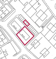
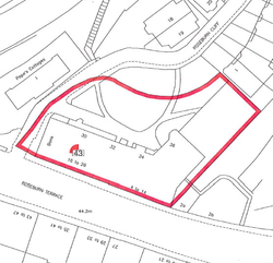
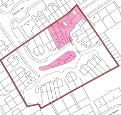
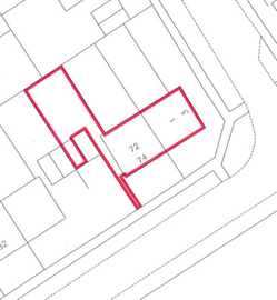
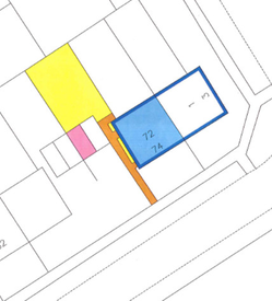
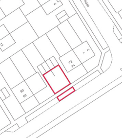
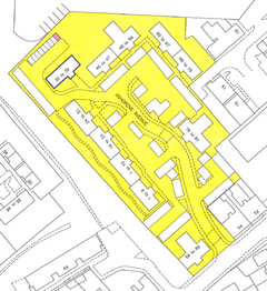
Scenario 8 - existing 1979 Act PRs that have been mapped tinting method, current application is for final registration of a flat in the tenement, and all rights & pertinents of the flat in the current application can be mapped.
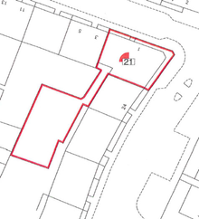
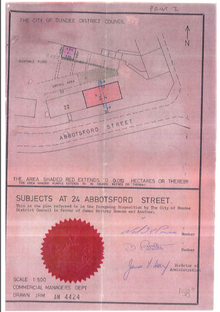
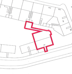
 | 3 of the 4 flatted properties comprising the tenement block have already been registered under the 1979 Act using the tinting method of mapping. |
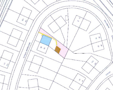 | The deed plan for the current application to register the fourth and final flat in the block agrees with all the previous registrations. This deed plan completes the picture of the full extent of ground pertaining to the block. |
 | Combining the information already held by the Keeper for the 3 PRs with that supplied in the current application, the tenement steading cadastral unit can clearly be identified as the area edged red. |
B - Tenement applications with some rights or pertinents outwith the tenement steading extent as they are owned in common with other tenements or houses
Scenario 9 - external common areas, single tenement block.
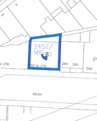
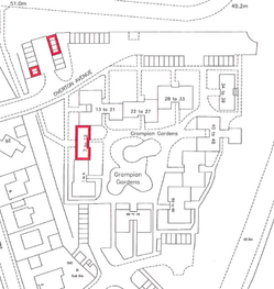
No existing 1979 Act or 2012 Act PRs, but the current 2012 Act application defines the tenement steading; the application includes a right in common to a defined shared area that is common to more than one tenement.
| The application describes the flat as being part of a tenement block with a right in common with the owners of all the flats in 17 tenement blocks to the rear common access road. The application contains a plan delineating the tenement steading extent and also delineating the extent of the rear common access road. |
 |
|
Scenario 10 - external common areas, single tenement block.
Existing 1979 Act PRs that have been mapped site plan method, and where the site plan extent includes a shared area that is common to more than one tenement.
Scenario 11 - external common areas, development of more than one tenement block.
No existing 1979 Act or 2012 Act PRs but the current application adequately defines either (i) the tenement steading, or (ii) the individual block & all pertinents of that block; the application includes a right in common to defined shared areas that are common to more than one tenement.
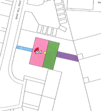
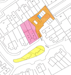
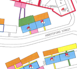
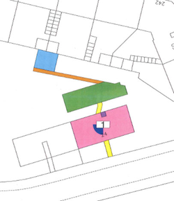
 | The tenement steading cadastral unit is set up as the block and any areas of exclusive and common ownership pertaining to the flats in that block. The tenement steading cadastral unit is mapped on the cadastral map, and can then be used for other flats within this block. In this example, each flat in the block has an exclusive garage, and details of the particular garages pertaining to each block is included in the Deed of Conditions. So the cadastral unit includes all garages pertaining to the flats in this block. If the legal settler required a plans reference for the extent of the development as defined in the Deed of Conditions, this will be shown on the cadastral map. To avoid confusion with cadastral units, please use a colour other than red to edge the development. |
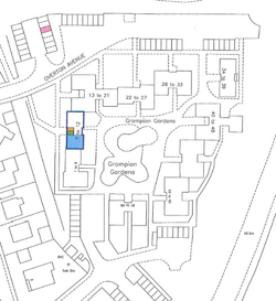 | The plans references required for the rights, etc disponed with the individual flat and that fall within the tenement steading are shown on a grouping containing the supplementary data. In this example, the flat is tinted blue on the second floor of the block, and the garage is tinted pink. The flat is sold with a right in common to the solum of the block edged blue, the bin store tinted brown and the drying cupboard tinted green. |
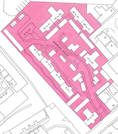
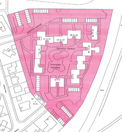 | A shared plot title sheet is set up for the common areas in the development that fall outwith the tenement steadings for each of the blocks. All flats that are sold with a share in these common areas will become sharing plot title sheets to this shared plot title sheet. In this example, the flat is sold with a 1/66th share in the common amenity areas shown on the plan to the Deed of Conditions. These areas have been mapped in the cadastral unit for the shared plot and have been tinted pink rather than edged red due to the complex nature of some of the shapes. The island sites, or holes, in this cadastral unit have been cut out using the Cookie Cutter tool in the Plan Creator. There may be a requirement in some developments to create more than one shared plot title sheet if there are common areas owned with different groups of proprietors within the development. For example, an area common to the whole development and an area common to only two blocks in the development. |
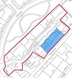
Scenario 12 - external common areas, development of more than one tenement block.
Existing 1979 Act PRs that were not mapped with a site plan extent for individual tenement blocks, but the current application adequately defines either (i) the tenement steading, or (ii) the individual block & all pertinents of that block; the application includes a right in common to defined shared areas that are common to more than one tenement.
 | The extended tenement steading cadastral unit is set up as the block with any areas of exclusive and common ownership pertaining to the flats in that block, plus any areas that are owned in common by more than just the flats in that block. The tenement steading cadastral unit is mapped on the cadastral map, and can then be used for other flats within that block. In this example, each flat in the block has an exclusive parking space, and details of the particular parking spaces pertaining to each block is included in the Deed of Conditions. So the cadastral unit includes all parking spaces pertaining to the flats in this block. Each flat is also sold with a 1/34th pro indiviso share to a common amenity area, and a 1 1/10th share in a common access and parking area. These were fully defined in the Deed of Conditions, and have been included in the extent of the tenement steading cadastral unit. A pink tint has been used to show this extended tenement steading cadastral unit due to the complex nature of some of the shapes. The island sites, or holes, in this cadastral unit have cut out using the Cookie Cutter tool in the Plan Creator. A brown edge has been used to show the extent of the development that was defined in the Deed of Conditions as the legal settler required a reference for this. |
 | The plans references required for the rights, etc disponed with the individual flat and that fall within the extended tenement steading are shown on a grouping containing the supplementary data. In this example, the block is tinted pink, and the parking space is tinted blue. The flat and garden ground are described verbally within the block so no plans references are provided for the flat or garden. The flat is sold with a 1/34th pro indiviso share to the common amenity area tinted yellow, and a 1 1/10th share in the common access and parking area tinted brown. |
Scenario 13 - external common areas, development of more than one tenement block.
Existing 1979 Act PRs that were not mapped with a site plan extent for individual tenement blocks, but the current application adequately defines either (i) the tenement steading, or (ii) the individual block & all pertinents of that block; Deed of Conditions adequately describes the development common areas but no rights of ownership in these common areas is conveyed.
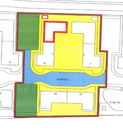 | The tenement steading cadastral unit is set up as the block, and any areas of exclusive and common ownership pertaining to the flats in that block. The tenement steading cadastral unit is mapped on the cadastral map, and can then be used for other flats within this block. In this example, each flat has a share in the common bin store pertaining to this block. So the cadastral unit includes the block and the bin store. A red edge has been used to show this tenement steading cadastral unit as it is a simple shape. No rights of ownership to common areas outwith the block and the bin store were sold with the flats. A brown edge has been used to show the extent of the development, a green tint to show the common parking areas, a blue tint to show the common access road, and a yellow tint to show the common amenity areas that were defined in the deed of conditions as the legal settler required a reference for these. These references are all shown on the cadastral map. |
In this example, the flat and its pertinents within the tenement steading cadastral unit are described verbally so there is no requirement for a grouping containing supplementary data. |
Scenario 14 - un-mappable external common areas, single tenement block.
No existing 1979 Act or 2012 Act PRs, but the current 2012 Act application defines the tenement steading; the application includes a right in common to a undefined shared area that is common to more than one tenement.
| The application describes the flat as being part of a tenement block with a right in common with the owners of all the flats in 17 tenement blocks to an undefined rear common access road. The application contains a plan delineating the tenement steading extent. |
 |
|
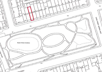
Scenario 15 - un-mappable external common areas, single tenement block.
Existing 1979 Act PRs that have been mapped site plan method, and which include a verbal reference to a shared area outwith the tenement steading that is common to more than one tenement. The current 2012 Act application also includes a right in common to the undefined shared area that is common to more than one tenement.
| The application describes the flat as being part of a tenement block with a right in common with the owners of all other surrounding properties to the undefined pleasure grounds known as Queen Street Gardens, west portion. The PRs define the tenement steading adequately and include only a verbal reference to the pleasure ground. |
 |
|
Scenario 16 - unmappable external common areas, development of more than one tenement block.
No existing 1979 Act or 2012 Act PRs but the current application adequately defines either (i) the tenement steading, or (ii) the individual block & all pertinents of that block; the application includes a right in common to undefined shared areas that are common to more than one tenement.
| The tenement steading cadastral unit is set up as the block and any areas of exclusive and common ownership pertaining to the flats in that block. The tenement steading cadastral unit is mapped on the cadastral map, and can then be used for other flats within this block. In this example, each flat in the block has an exclusive garage, and details of the particular garages pertaining to each block is included in the Deed of Conditions. So the cadastral unit includes all garages pertaining to the flats in this block. If the legal settler required a plans reference for the extent of the development as defined in the Deed of Conditions, this will be shown on the cadastral map. To avoid confusion with cadastral units, please use a colour other than red to edge the development. |
| The plans references required for the rights, etc disponed with the individual flat and that fall within the tenement steading are shown on a grouping containing supplementary data. In this example, the flat is tinted blue on the second floor of the block, and the garage is tinted pink. The flat is sold with a right in common to the solum of the block edged blue, the bin store tinted brown and the drying cupboard tinted green. |
As the common areas in the development that fall outwith the tenement steadings for each of the blocks cannot be mapped on the cadastral map, they will either (i) be omitted from the title sheet for the flat, or (ii) the application to register the flat will be rejected. In this example, the flat is sold with a 1/66th share in the undefined common amenity areas referred to in the Deed of Conditions. The Deed of Conditions was recorded prior to 8 December 2014 so these rights will be omitted from the title sheet for the flat but the application for registration can proceed. |
Scenario 17 - unmappable external common areas, development of more than one tenement block.
Existing 1979 Act PRs that have been mapped site plan method based on the extent of a whole development, and which include a verbal reference to a shared area that is common to more than one tenement block. The current 2012 Act application adequately defines either (i) the tenement steading, or (ii) the individual block & all pertinents of that block, and also includes a right in common to the undefined shared area that is common to more than one tenement block.
 | Various flats in the development have already been registered under the 1979 Act using the site plan method of mapping. Under the 1979 Act, it was acceptable to define the site plan extent as being the extent of the whole development; under the 2012 Act this is no longer appropriate. The Keeper must now set up a tenement steading cadastral unit for each individual tenement within a development. |
 | The tenement steading cadastral unit is set up as the block and any areas of exclusive and common ownership pertaining to the flats in that block. The tenement steading cadastral unit is mapped on the cadastral map, and can then be used for other flats within this block. In this example, each flat in the block has an exclusive parking space, and details of the particular parking spaces pertaining to each block is included in the Deed of Conditions. So the cadastral unit includes all parking spaces pertaining to the flats in this block. A plans reference (a brown edge) has been shown on the cadastral map for the extent of the Deed of Conditions as the legal settler requires this when editing in the rights and burdens to the title sheet. (N.B. Now we are using the Plan Creator, please consider other options rather than 2 overlapping edges - perhaps use a tint for the cadastral unit, or put the deed of conditions reference on a grouping containing an additional layer (or view) of the cadastral map). |
 | Any plans references required for the rights, etc disponed with the individual flat and that fall within the tenement steading would be shown on a grouping containing supplementary data. In this example, the flat is tinted blue on the ground floor of the block, and the parking space is tinted pink. The flat is sold with a right in common to the common entrance hall tinted yellow. All other rights & pertinents within the tenement steading extent are described verbally in the deeds and will be included as verbal references in the title sheet. |
As the common amenity areas in the development that fall outwith the tenement steadings for each of the blocks cannot be mapped on the cadastral map, the right in common to those areas will either (i) be omitted from the title sheet for the flat, or (ii) the application to register the flat will be rejected. In this example, the flat is sold with a 1/50th share in the undefined common amenity areas referred to in the Deed of Conditions. The Deed of Conditions was recorded prior to 8 December 2014 so these rights will be omitted from the title sheet for the flat but the application for registration can proceed. |
C - Tenement applications where a restricted tenement steading cadastral unit is to be set up
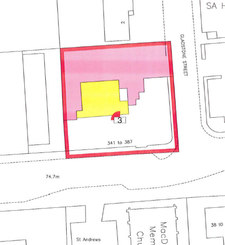
Scenario 18 - single tenement block.
No existing 1979 Act or 2012 Act PRs, the current 2012 Act application does not define the tenement steading extent, but the building and all rights and pertinents of the flat can be mapped from the current application.
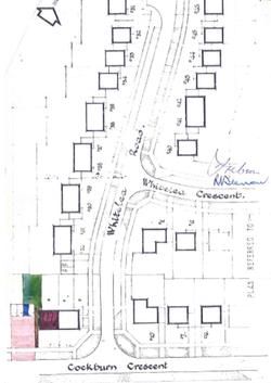 | None of the 4 flatted properties comprising the tenement block have been registered yet. The current application does not contain an extent for the full tenement steading, however it contains enough detail to allow the building and all rights and pertinents of the flat to be mapped. These will be used by the Keeper to derive a restricted extent for the tenement steading cadastral unit. The common access driveway is common to more than one tenement so will either be set up as a shared plot or mapped under the transitional provisions. |
 | The tenement steading cadastral unit is mapped onto the cadastral map and is shown with a red edge (or with a tint if more appropriate). |
 | Any plans references required for the rights, etc disponed with the individual flat and that fall within the tenement steading will be shown on a grouping containing supplementary data. In this example, the solum of the block is edged blue, the flat is tinted blue on the upper floor of the block, the parking space is tinted pink, and the exclusive garden ground is tinted yellow. The flat is sold with a right in common to the common path tinted brown. All other rights & pertinents that are described verbally in the deeds fall within the tenement steading extent and can be included as verbal references in the title sheet. |
 | As no other shares in the common access driveway have been registered previously, a shared plot title sheet & cadastral unit will be set up for the areas edged red. |
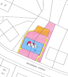
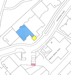
Scenario 19 - single tenement block.
Existing 1979 Act PRs that have been mapped tinting method, the current 2012 Act application does not define the tenement steading extent, but the building and all rights and pertinents of the flat can be mapped from the current application.
 | 2 of the 6 flatted properties comprising the tenement block have been registered under the 1979 Act, and have been mapped using the tinting method. |
 | The current application does not contain an extent for the full tenement steading, however it contains enough detail to allow the building and all rights and pertinents of the flat to be mapped. These, together with the PRs, will be used by the Keeper to derive a restricted extent for the tenement steading cadastral unit. |
 | The tenement steading cadastral unit is mapped onto the cadastral map and is shown with a red edge (or with a tint if more appropriate). |
 | Any plans references required for the rights, etc disponed with the individual flat and that fall within the tenement steading will be shown on a grouping containing supplementary data. In this example, the solum of the block is tinted pink and mauve, the flat is described verbally on the upper floor of the block, the vegetable plot is tinted blue, and the exclusive bin cupboard is tinted mauve on the ground floor. The flat is sold with a right in common to the common paths tinted yellow and brown, and a right in common to the drying green tinted green. All other rights & pertinents that are described verbally in the deeds fall within the tenement steading extent and can be included as verbal references in the title sheet. |
Scenario 20 - development of more than one tenement block.
Existing 1979 Act PRs that have been mapped tinting method or site plan method based on the extent of a whole development, and which include a plans reference to a shared area that is common to more than one tenement block. The current 2012 Act application does not define the tenement steading extent, but the building and all rights and pertinents of the flat can be mapped from the current application.
 | The current application does not contain an extent for the full tenement steading, however it contains enough detail to allow the building and all rights and pertinents of the flat to be mapped. These, together with the PRs in that block, will be used by the Keeper to derive a restricted extent for the tenement steading cadastral unit. In this example, the block and 3 exclusive parking spaces initially comprise the restricted tenement steading cadastral unit. Each flat in the block is also sold with a 1/54th share to a common amenity area with all other flats in the development. The extent of this common area can be mapped from the application. As there are 1979 Act PRs already registered with a share in this common amenity area, the extent of the tenement steading cadastral unit is then extended to include this common area. The tenement steading cadastral unit is mapped on the cadastral map, and can then be used for other flats within that block. A pink tint has been used to show this extended tenement steading cadastral unit due to the complex nature of some of the shapes. The island sites, or holes, in this cadastral unit have been cut out using the Cookie Cutter tool. |
 | The plans references required for the rights, etc disponed with the individual flat and that fall within the extended tenement steading are shown on a grouping containing supplementary data. In this example, the block is edged blue, and the parking space is tinted pink. The flat is described verbally within the block so no plans reference is provided for the flat. The flat is sold with a 1/54th pro indiviso share to the common amenity area tinted yellow. |
Scenario 21 - either single tenement block or development of more than one tenement block.
No existing 1979 Act or 2012 Act PRs, the current 2012 Act application does not define the tenement steading extent, but does define the building. Verbal references to rights or pertinents of the flat that fall outwith the building.
| For example, only the building and a parking space are defined, however there is a right in common to a back court owned in common with the other flats in the block. It is clear from this that the back court does not fall within the building, nor does it fall within the parking space. Therefore the current application does not contain either a plan or full bounding description of the tenement block and all pertinents (exclusive or common) of the flat; this means the Keeper cannot derive a restricted tenement steading cadastral unit on the cadastral map. The application should be rejected. |
Scenario 22 - existing restricted tenement steading cadastral unit, current application includes rights to additional areas of ground.
 | A previous 2012 Act application has been registered and a restricted extent for the tenement steading cadastral unit exists on the cadastral map. There is therefore no requirement for the current application to contain an extent for the full tenement steading. It must, however, contain enough detail to allow any additional areas of ground to be mapped and added to the existing tenement steading cadastral unit. |
 | The current application is to register a flat that is located within the existing tenement steading cadastral unit. In addition to any rights or pertinents over ground within the existing tenement steading extent, the current application includes an exclusive right of ownership in an area of front garden ground that is adequately described in the deed for extent for the flat. The extent of the tenement steading cadastral unit is therefore extended to include the additional area of ground identified in the current application as pertaining to a flat in the tenement. |
D - Tenement applications for a flat in one tenement block with parking in another tenement block
Scenario 23 - flat or unit in one tenement block that has a garage or parking space located within another tenement block in the same development.
Scenario 24 - flat or unit in one tenement block that has a garage or parking space located within another tenement block in another development.
Registers of Scotland (RoS) seeks to ensure that the information published in the 2012 Act Registration Manual is up to date and accurate but it may be amended from time to time.
The Manual is an internal document intended for RoS staff only. The information in the Manual does not constitute legal or professional advice and RoS cannot accept any liability for actions arising from its use.
Using this website requires you to accept cookies. More information on cookies.
Feedback