Identifying the Tenement Steading Extent - Guidance for Referral Officers
- Editor9
Remember - whenever possible, the tenement steading cadastral unit will comprise the full extent of all flats in a block, their rights and pertinents. By reflecting the full extent of the tenement steading, the requirement to do consequential updates of registered titles will be greatly reduced. If, however, this is not possible from the information available to the Keeper, consideration should be given to setting up the tenement steading cadastral unit with a restricted extent that comprises, as a minimum, the extent of the tenement building, all registered flats, their rights and pertinents.
Common referral topics
How do we deal with verbal references to areas when identifying a tenement steading extent?
Section 16 of the 2012 Act allows the Keeper to include verbal descriptions of rights of ownership in a title sheet, but only in tenement properties - all other types of property must have the extent of ownership (common or shared) mapped on the cadastral map. In tenements, provided the tenement steading cadastral unit is mapped, then rights to areas within that cadastral unit can be verbalised. The page When to accept verbal descriptions includes more detail on the requirements for verbal descriptions.
Particular attention needs to be paid to verbal descriptions of exclusive or common ownership when a restricted extent tenement steading cadastral unit is being considered. As s16 allows us to have verbalised references within the tenement steading cadastral unit, it follows that all verbalised references must fall within it and not lie outside it. All verbalised references in the application to exclusive rights and pertinents, and to common rights to areas shared only by flats within the tenement block, must be located within the existing or proposed restricted tenement steading extent. If it is apparent from the application that these verbalised rights do not fall within that restricted tenement steading extent, then the application should be rejected.
For example:
| There is an existing 1979 Act title for the 2nd floor flat registered in the block of three flats that has been mapped tinting method and does not define the full tenement steading extent. The flat is tinted blue, the common entrance and stairs are tinted yellow, and the common bin store is tinted green. The current application relies on a verbal description of being the ground floor flat of the block of three flats with rights in common to the common entrance and stairs, the common bin store - we would be reasonably content that by drawing the tenement steading cadastral unit around the tints from the PR that the current flat, and its common rights to the entrance, stairs and bin store would lie within that extent. So it would be ok to proceed with that as a restricted extent tenement steading cadastral unit. However, what if the current application also includes another verbally described right? "...Together with the exclusive area of garden ground lying to the rear of the block...." From the information in the application and already held by the Keeper, it isn't possible to draw the cadastral unit extent to include the rear garden ground without guessing where that ground is. And it's not our job to make guesses. Therefore the application should be rejected as it does not contain sufficient information for the Keeper to derive an extent for the tenement steading extent cadastral unit that includes a minimum of the tenement building, the flat and all pertinents (exclusive or common) of the flat being registered. The applicant should re-submit the application with either (1) a plan showing the area of exclusive garden ground, or (2) a plan showing a full or restricted tenement steading extent that includes the area of garden that their client has a verbally described right of ownership to. |

Adding new ground to restricted extent tenement steading cadastral units
When a restricted extent tenement steading cadastral unit has previously been set up, it will need to be considered whenever a further flat or unit within that block is registered to check whether the cadastral unit extent should be expanded to include additional areas of ground. This check will be needed upon each further application until such times as all flats or units are registered, and the cadastral unit represents the full extent of the tenement steading.
The normal consideration of the current application should be completed -
- does it meet the requirements for registration?
- is the description of the flat acceptable?
- can we map any exclusive or common pertinents, or are there suitable verbal descriptions for them?
In addition, if the current application includes ownership rights to additional areas not yet included in the restricted extent tenement steading cadastral unit, you will need to check it if is possible to identify what the new, extended extent will be?
- Can the additional area be identified and mapped from the information in the application?
- Or is there a plan showing the new, extended extent of the tenement steading cadastral unit in the application?
- The guidance on final flat or outer boundaries that can be found on the Identifying tenement steading extents - General page can also be considered. It may be possible to convert the restricted extent to a full extent before all flats in the block are registered.
- Remember to also take into account the guidance in the section above relating to verbal descriptions and when they can be accepted/when an application should be rejected?
- If the new extended extent can't be identified, the application should be rejected.
Please note, land belonging to another party outwith the tenement over which a servitude right exists should not be included in the cadastral unit.
If the new extent can be identified, the current applications should proceed with the newly extended cadastral unit extent mapped on the cadastral map, and the references pertaining to the flat and its rights in a grouping or groupings showing Supplementary Data.
All existing 2012 Act PRs should also be updated to reflect the new extent of the tenement steading cadastral unit. An MU request should be completed and sent to Mapbase Maintenance to update the tenement steading cadastral unit extent of all earlier 2012 Act PRs in the block - please ensure that the updated extent is available in, for example, a DCU or COF file and available for MBM to copy & paste. No Plans HEO approval required in this particular scenario, although AO plans officers should get EO approval for this type of MU request. There is no requirement to notify the owners or agents of the earlier 2012 Act PRs in the block as no change has been made to the text of their title sheets or the extent of their rights, etc. By increasing the extent of the cadastral unit, all we are doing is increasing the identification of the area within which their rights lie but we are not altering the rights themselves. Please note, when we decrease the extent of a tenement steading cadastral unit for any reason, notification is required as we want to ensure our customers understand that we have not removed any of their rights - these types of scenario are covered more fully in guidance sections below.
Whilst the scenario should not really occur as restricted extent tenements should include as a minimum the full extent of the tenement building, if it is found that the address of the tenement steading cadastral unit also needs "expanded" when additional ground is added in, then this can be done by way of a TU application rather than an MU application. For example, a restricted tenement steading cadastral unit is set up and referred to in the title sheet(s) as 74 to 86 Royal Way; a further flat is then registered within the block and the extent has to be expanded to include the exclusive garden ground and bin store. It is noticed at this time that the new flat is 72 Royal Way therefore the 2012 Act PRs that refer to the cadastral unit will need to be updated to reflect the block description of 72 to 86 Royal Way. Appropriate notes should be added to the LRS for all affected titles for future reference.
How do we identify the tenement steading extent when there are rights in common shared by different blocks?
There are two main groups of this type of casework scenario, and examples of each can be found in the Tenement scenarios page, (see section B on that page):
- non-development - for example, two (or more) tenement blocks that share an area of common ground to the rear or a shared driveway between the blocks.
- development - for example, a modern development of mixed houses and flats where all property owners own a share in the development common areas; these often have a deed of conditions that affects.
There are 2 key things to remember when dealing with such an application:
Firstly, the normal policies on mapping common areas apply to those areas that are shared by more than one block. We must be able to map them before the right can be included in the title sheet. This can be either when have a separate plans reference for the area that is common to more than one block (for instance, a shared driveway shown on deed plan), or we have an extent for a tenement steading that includes the said common area (for instance, we have existing 1979 Act site plan extents for two neighbouring blocks that each include the same back court area in their site plan extent). If mappable, we consider whether they should be set up as shared plots, mapped as pertinents or mapped under the transitional provisions of schedule 4 of the 2012 Act.
- For example, a restricted extent for a tenement steading cadastral unit may be derived for a tenement block in a development, with all flats in all the blocks owning a right in common to the fully defined development amenity areas.
If there are no PRs containing rights in common to the development amenity areas, then the amenity areas should be set up as a separate shared plot title with all flats becoming sharing plot titles.
If there are already 1979 Act PRs containing rights in common to the development amenity areas, then the amenity areas should be mapped under the transitional provisions of schedule 4 of the 2012 Act.
However, if the extent of the area that is common to more than one block cannot be identified, then the usual consideration about whether we should omit the right in common or reject the application should be undertaken.
For example, an extent for a tenement steading cadastral unit may be derived for a tenement block in a development, with all flats in all the blocks including a right in common to some undefined development amenity areas.
If the undefined development amenity areas cannot be mapped and are described in a pre-8 December 2014 deed, the right in common should be omitted from the title.
If the undefined development amenity areas cannot be mapped and are described in a post-8 December 2014 deed, the application should be rejected.
Secondly, if the area that is common to more than one block is mappable, we then consider how it affects the tenement steading cadastral unit we are defining (both full and restricted extents).
- If the area is to be set up as a separate shared plot, then this will not alter the tenement steading cadastral unit extent that has been identified for the block/flat.
- If the area is to be mapped under the transitional provisions, the tenement steading cadastral unit extent that has been identified for the block/flat should be expanded to include the extent of the common area that is shared by more than one block.
- If the area is to be treated as a pertinent, then the tenement steading cadastral unit is mapped in the same way as under the transitional provisions.
| Non-development scenario | ||
|---|---|---|
|
|
|
Existing registration There is an existing 1979 Act title for the ground floor flat registered in the neighbouring 4-in-1-block that has been mapped tinting method and does not define the full tenement steading extent. The flat is verbally described within the solum tinted blue, the exclusive garden is tinted pink, the common path (shared with upper flat in same block) is tinted mauve, and there is a common path (shared with upper flat in same block and with the upper and lower flat in neighbouring block) is tinted brown. | Current application The current application is for the first flat out of a 4-in-1-block and does not define the full tenement steading extent. The upper floor flat is verbally described within the solum tinted blue, the exclusive garden is tinted pink, the common path (shared with ground flat in same block) is tinted mauve, and there is a common path (shared with ground flat in same block and with the upper and lower flat in neighbouring block) is tinted brown. Setting aside the area shared by two blocks to start with, we have sufficient information to define a restricted extent as we have the solum of the block and a plans reference for all areas of ground pertaining to the flat. With regard to the area that is common to more than one block, we apply the normal rules on mapping common areas - create a shared plot, map under transitional provisions, or treat as a pertinent. In this instance, there is already an existing 1979 Act title with the right in common mapped, therefore we can apply the transitional provisions of Schedule 4 of the 2012 Act. | Tenement steading cadastral unit - restricted extent The restricted extent tenement steading cadastral unit is extended to include the area that is common to both blocks. In effect, this means that the area that is common to both blocks will be included within the tenement steading cadastral units for both blocks once one is created for the neighbouring 4-in-a-block. |


| Development scenario - shared plot | |||
|---|---|---|---|
|  |
|  |
Current application There are no existing 1979 Act or 2012 Act registered titles yet in this development, so the current application will set the style for future registrations. | Tenement steading cadastral unit extent Setting aside the development common area shared by all the blocks to start with, we have sufficient information to define the extent as we have a plans reference for the solum of the block and the common bin store. Having considered the various common rights, the decision is taken to:
Therefore the tenement steading cadastral unit extent for this block is the solum of the block plus the bin store pertaining to the flats in this block. | Supplementary data The individual references required (in this instance, the solum of the block and the bin store) are plotted as normal in a grouping showing supplementary data for the flat's title sheet. | Shared plot extent The title sheet for the flat is set up as a Sharing Plot title sheet, and a Shared Plot title sheet is set up for the development common areas. In this instance, a tint is used as some of the excepted areas are too small to clearly show if red edging is used. |


| Development scenario - transitional provisions | |||
|---|---|---|---|
 |  |  | |
Existing registration Although there are no existing 1979 Act or 2012 Act registered titles yet in the block, there is one 1979 Act title in the development that has been mapped using the tinting method. The current application will set the style for future 2012 Act registrations in the development. The registered flat is verbally described within its block, with a:
| Current application The flat is verbally in the same style as the previous registration of the flat in the other block in the development. So it is verbally described within its block, with a:
| Tenement steading cadastral unit extent Setting aside the development common areas shared by all the blocks to start with, we have sufficient information to define the steading extent as we have a plans reference for the solum of the block and for the common bin store. With regard to the area that is common to more than one block, we apply the normal rules on mapping common areas - create a shared plot, map under transitional provisions, or treat as a pertinent. In this instance, there is already an existing 1979 Act title with the development common areas mapped, therefore we can apply the transitional provisions of Schedule 4 of the 2012 Act. Therefore we add the extent of the development common areas to the extent already established for the block and bin store. In effect, this means that the area that is common to all blocks will be included within the tenement steading cadastral units for all blocks once one is created for each of the blocks in the development. | Supplementary data The individual references required (in this instance, the solum of the block, the bin store, and the development common areas) are plotted as normal in a grouping showing supplementary data for the flat's title sheet. |
It is also possible to come across development scenarios where a restricted extent tenement steading cadastral unit is required, even though there is a Deed of Conditions affecting the development.
- An example of when it may not be possible for the applicant to identify the full extent of all rights and pertinents relating to all flats in the block could be when not all flats in the block have been sold on as individual flats yet by the original builder and there is no Deed of Conditions identifying all the areas concerned.
- Another example may be when the flat is located within a large block that forms part of a development of multiple blocks, with exclusive parking spaces located throughout the development. Not all parking spaces are registered yet, and the Deed of Conditions does not identify which parking space pertains to which flat. It would be unreasonable of the Keeper to expect the applicant to investigate numerous unregistered properties to establish all the spaces that pertain to all flats in a block.
- In each of these examples, a restricted extent for the tenement steading cadastral unit can be set up based on what is known to the Keeper & the applicant at the time of registration (ie, the areas defined in the current application plus any existing PRs).
- If a restricted extent is used, it will be updated by the Keeper to include additional areas of ground (for example, additional parking spaces) that are registered as part of future applications to register other flats in the same block.
What do we do when an application includes a different extent for a tenement steading cadastral unit from the one already held by the Keeper?
This can occur for multiple reasons, including incorrect extent provided by current applicant, incorrect extent provided by previous applicant, incorrect extent previously identified by the Keeper, or new information is now available that shows either the applicant or the Keeper that there is a necessary amendment to the tenement steading cadastral unit extent.
What do we do when a flat has a parking space or garage that is in another block or is not in the same development?
There are developments in Scotland where some of the pertinents of the flats in one tenement block are located within another tenement block - the most common example of this is a development co mprising several blocks of flats, one of which blocks contains parking spaces or garages that are pertinents of flats in one or more of the other blocks. If you receive a referral about this scenario, the guidance on page How to map a flat with parking in another block will help you.
There are properties in Scotland where a flat is located within one tenement block (in a multi-block development, or in a single block development), and the owner of the flat also owns a separate parking space or garage that is located outwith that development (perhaps located in another development, or simply a separate garage located in the neighbourhood). If you receive a referral about this scenario, the guidance on page How to map a flat with remote parking will help you.
When it is appropriate to combine two (or more) existing steadings into a larger tenement steading cadastral unit?
There may occasionally be circumstances where it is expedient for the Keeper to combine two or more existing tenement steadings/site plan extents into one larger tenement steading cadastral unit, using the power given to the Keeper in section 13 (2) of the 2012 Act.
- Decisions on this type of scenario should be made by a plans HEO, with the assistance of a plans senior advisor if necessary.
- There should be some relationship between the properties in the two existing steadings/site plan extents.
This should not be done as an attempt to circumvent the need to split a development up into tenement blocks and shared common areas.
The most common or straightforward scenario is when a flat or unit actually straddles two tenement blocks, and an example is shown below. There are other, more complex scenarios when it might be appropriate to combine two or more blocks into a larger steading, and some examples are shown in the Complex Steading Extents section further down this page.
| Example of when combining steadings is not appropriate | ||
|---|---|---|
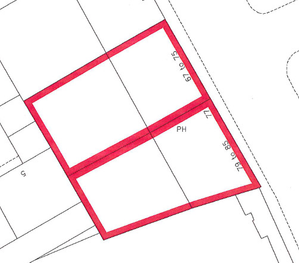 | | |
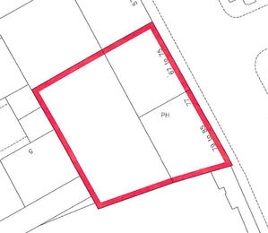
Existing registrations Flats in both neighbouring tenements have been registered under the 1979 Act using the site plan method of mapping with verbal descriptions of the flats and their pertinents. | Current application The Disposition in the current application describes two flats in the (First) and (Second) place, both described verbally and being the northmost first floor flat of the block 67 to 75 xx Street, and the northmost second floor flat of the block 77 to 85 xx Street. No deed plans are provided for either property, however the Keeper does already hold suitable extents for the two tenements blocks. | Tenement steading cadastral units In this scenario, it is not appropriate for the Keeper to combine the two existing tenement steadings/site plan extents into one larger tenement steading cadastral unit. Although two properties are being described and sold in the same deed, there is no relationship between the two flats other than they are owned by the same person. So the current application should be split into two applications creating two title sheets, one for each flat. The tenement steading cadastral units will be based on the existing acceptable site plan extent held by the Keeper. |
| Example of when combining steadings is appropriate | ||
|---|---|---|
| 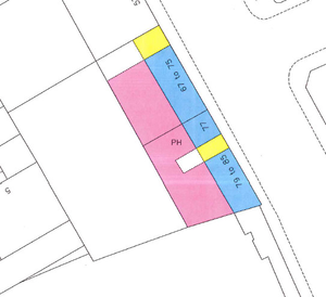 |  |
Existing registrations Flats in both neighbouring tenements have been registered under the 1979 Act using the site plan method of mapping. | Current application The deed plan for the current application to register the ground floor public house premises with basement cellars underneath shows that these premises extend at ground and basement floor levels across both buildings. The ground floor pub is shown tinted pink and blue, with the basement cellars tinted blue and yellow. | Tenement steading cadastral unit In this scenario, it is expedient for the Keeper to combine the two existing tenement steadings/site plan extents into one larger tenement steading cadastral unit (edged red on the plan (above). The extent of the pub and cellars will be shown in a grouping containing the supplementary data. All future flats or units within these two tenement buildings will be described as forming part of this larger tenement steading cadastral unit. If a reference is required by the legal settler for the solum of an individual tenement building (in other words, for one of the original site plan extents), this plans reference can be provided in the grouping containing the supplementary data for that particular flat. |
The alternatives to this would be to either:
- split the application into two title sheets, each containing the part of the property falling within each existing tenement steading. Although this may seem straightforward from a plans perspective, it can be difficult to achieve in practice as consideration would have to be given to the property section descriptions, and the legal officer would have to consider which rights and burdens were included in which title sheet; or
- create a tenement steading cadastral unit that appears to overlap with the one next door (i.e. is the extent of one existing tenement steading plus the area of the flat that extends over the one next door) but is restricted by way of notes in the property section of the title sheet. For example, "As to the part tinted pink on the cadastral map, only the upper floor flat is included in this cadastral unit". This approach is perhaps best used when only a small section extends into the neighbouring block, for example, an area of cellarage that extends partly beneath the block next door.
These two alternative options should only be used with the approval of a Plans senior caseworker to ensure the most appropriate course of action is taken.
Complex steading extent scenarios
Section 16 of the Land Registration etc. (Scotland) Act 2012 states: Where the Keeper considers it appropriate in relation to a flatted building to do so, the Keeper may, instead of representing each registered flat in the building as a separate cadastral unit, represent the building and all the registered flats in it as a single cadastral unit.
This is key to the Keeper's policy on the registration of tenements - a tenement steading cadastral unit should represent only one tenement, and each tenement should have its own cadastral unit and it should contain all flats and pertinents for all flats within that block or tenement. Registration officers should always try and follow this policy, whenever possible. There should also be sufficient information in the application or in information already held by the Keeper to enable us to comply with this policy as we need to be able to identify the extent of the tenement steading cadastral unit.
The main guidance page on How to Identify a Tenement Steading Extent contains a lot of information that should be useful when registering the majority of tenement properties and should be the first point of reference when considering a tenement steading extent. As registration knowledge and practice has evolved since the introduction of the 2012 Act, we have developed rules and guidance that can be applied in certain scenarios. For example, we have developed practices for identifying the extent of the tenement steading in 4-in-a-block or split villa scenarios. And we have agreed practice in place for those scenarios where it is not possible to identify a full steading extent - Restricted extent tenement steadings. There are policies and practices in place for neighbouring tenements that share, for example, a mutual back court area, and these can be seen in the Tenement Scenarios page - with properties such as these, remember that the normal rules on shared plots and applying the Transitional Provisions for common areas owned by more than one tenement apply. And, in the guidance above on common referral scenarios, it has been tried to show how the agreed tenement policies can be applied in a variety of seemingly complex scenarios.
However, it is recognised that not every tenement property can be "forced" to fit into a simple, single tenement steading scenario, and the intention of this section is to give a feel for the types of consideration and pragmatic decision that sometimes have to be made by Plans HEOs, with support from the Plans senior caseworkers as required.
Non-traditional tenement blocks
Some of the more modern flats, built generally from the 1960s onwards, can be problematic due to the architecture of these developments. Some have walkways or deck access, some have vennels and shared parking areas, some are on split levels, some have multiple stairwells. With developments and blocks such as these, we have to treat each one on its own merits and consider the terms of the conveyancing, what the solicitor is actually required to provide in terms of the 2012 Act, how practical or cost effective would it be for either the solicitor or RoS to delve deeper into multiple other sasine titles, how the development is depicted on the OS, how complicated it would be to use multiple restrictive notes on the tenement steading cadastral units, etc.
The examples below are mocked-up to illustrate these types of considerations, rather than picking apart particular real-life applications.
| Example 1 |
|---|
|
 |
In this example, the flatted complex is defined as a single building on the OS map, however the conveyancing refers to the flats forming part of two separate blocks. In an ideal world, we would create two tenement steading cadastral units, one for each block. However, there is a mixture of common rights shared by flats in each block and common rights shared by all flats in the complex. Some of those common rights are mappable, some are described verbally, some are at floor levels (the pend & shared hallways), some are outside, others are within the building (common stair wells between the two blocks). Given the complexity of the rights, the size of the complex and the illustration of the complex as a single building on the OS map, it would be acceptable to take a pragmatic decision and establish one tenement steading cadastral unit flat for this flatted complex - edged red on the cadastral map. The conveyancing descriptions of the individual flats that refer to the individual blocks can still be used when putting together the property descriptions. |

| Example 2 |
|---|
|
 |
In this example, again the flatted complex is defined as a single building on the OS map, however the conveyancing refers to the flats forming part of several blocks within the complex. We would start by considering whether it was possible to create a separate tenement steading cadastral unit for each block. However, there is a complicated mix of duplex (two storey) flats and rights on different floor levels, to the ground floor vennel areas, to first floor external walkways shared by all blocks, etc. Given the complexity of these rights, the size of the complex and the illustration of the complex as a single building on the OS map, it would be acceptable to take a pragmatic decision and establish one tenement steading cadastral unit flat for this flatted complex - edged red on the cadastral map. The conveyancing descriptions of the individual flats that refer to the individual blocks can still be used when putting together the property descriptions. |

| Example 3 |
|---|
  |
 |
In this example, the flats all form part of a single large block so that allows us to create a single tenement steading cadastral unit. However, the complexity lies with the ground beyond the building itself and the rights that pertain to the flats. This small development contains the main tenement block facing the road together with a number of individual houses and a smaller separate block of flats to the rear. There is ground that is owned in common by all the properties. Normally, we would simply apply the guidance on mapping a tenement in a mixed or multi-tenement development (see scenarios in Section B of the Tenement Scenarios page and chose the most appropriate style. In this example, there are previous 1979 Act registrations therefore we would choose the style for tenements being mapped under the Transitional Provisions - excluding the other houses and block but including the ground owned in common within the tenement steading cadastral unit. This would result in a tenement steading cadastral unit as shown tinted pink, above. There is an added complication, though. Some of the individual houses to the rear are raised off the ground with carports underneath, and all properties in the development (flats & houses) own an individual car port. We therefore also have to apply our guidance on flats with garages, etc outwith the block and make use of restrictive notes. This would result in a tenement steading cadastral unit as shown tinted pink and blue, above, with restrictive notes being added to the property section: “As to the parts tinted blue on the cadastral map only the car ports hatched brown beneath the elevated houses are included in this cadastral unit.”. And the final complication here is that we do not know yet from the information that was included in the application or from the information we already hold from previous registrations all of the carports that pertain to all of the flats in our block. So the resulting tenement steading cadastral unit will be a restricted extent for now - as additional flats and car ports are registered, the brown hatching can be updated accordingly. |
Back courts and rear ground
With more traditional city-centre tenements of residential flats, because they are usually built in a regular pattern, they are normally more straightforward to establish the tenement steading extent, particularly as the major area deed referred to in the conveyancing often has a verbal description of the plot or Lot of land upon which the block is built. When we do experience difficulties when identifying the extent of a tenement steading cadastral unit, it is often due to the common back court or rear ground.
As with all tenements, we should start with the view that we need to identify a steading extent for a single block, however, there may be occasions where we need to consider if this is possible, and if there is a pragmatic alternative.
The example below is mocked-up to illustrate these types of considerations, rather than picking apart particular real-life applications.
| Example 1 |
|---|
|
|
In this example, there are three adjoining tenement blocks built on a roughly triangular major area. The site plan extent of the 1979 Act registrations is the full triangle edged red, although the conveyancing descriptions clearly identify 3 separate tenement blocks with no roof or solum being shared between the blocks. Therefore we should start by saying we need three tenement steading cadastral units for the three blocks. The complexity is introduced because all three blocks share the verbally described rear ground. Normally, we would simply apply the guidance on mapping a tenement with rights to areas shared with other tenements (see scenarios 9 & 10 in Section B of the Tenement Scenarios page) and chose the most appropriate style. In this example, there are previous 1979 Act registrations therefore we would choose the style for tenements being mapped under the Transitional Provisions - excluding the other blocks but including the rear ground owned in common within each of the three tenement steading cadastral units. This works well when either the rear ground is defined in a deed plan/in the application, or when the tenements are defined on the OS map with a straightforward rear wall - no projections or outbuildings or garden wall features. Our difficulty in this example is because the rear ground is verbally described, the submitting agent hasn't provided a mapped extent for the rear ground, there are other features at the rear of all three blocks shown on the OS map, and several of the ground floor or garden flats also include a verbally described area of exclusive garden ground ex adverso the flat. So our choices here are to (i) reject the application as we cannot identify a tenement steading extent for the single block and insist that the applicant provides a mapped extent of the common rear ground with any re-submitted application, but this would mean the agent has to investigate the titles of properties not belonging to their client and possibly even enter into correspondence with other flat owners to establish who owns what area, (ii) guess the extent of the rear ground, but our role at RoS is to accurately map titles on the Land Register so guessing is not appropriate, or (iii) find a pragmatic solution that allows flats in all three blocks to be registered. Given the verbal rights to the rear ground and the unclear picture of the extent of the exclusive ground pertaining to each individual block, knowing that the three blocks adjoin, and knowing from the prior title history that they were all built on the same major area by same builder, it would be acceptable in this instance to take a pragmatic decision and establish one tenement steading cadastral unit for the three blocks - edged red on the cadastral map. The conveyancing descriptions of the individual flats that refer to the individual blocks can still be used when putting together the property descriptions. |


Internal divisions
Town centres often include mixed use tenements with shops, offices and flats, and these are not always built in a regular pattern. Whilst with most of them it is clear from the current application or from previous registrations what the extent of the tenement steading cadastral unit is for each single block, and the depiction of the buildings on the OS map is often helpful with this, there are some that are more complex. As the properties were built and developed in a more piecemeal fashion than in the more regular residential blocks we often see, there can be situations where the internal divisions on different floor levels do no align with the frontage of the blocks. As with all tenements, we should start with the view that we need to identify a steading extent for a single block, however, there may be occasions where we need to consider if this is possible, and if there is a pragmatic alternative.
The example below is mocked-up to illustrate these types of considerations, rather than picking apart particular real-life applications.
| Example 1 |
|---|
|
 |
In this example, there are five adjoining tenement blocks according to the descriptions in the deeds, but only three main divisions are shown on the OS map. There is an RA which covers the whole area, and the 1979 Act PRs use the RA extent as their site plan extent - edged red. There are a mixture of shops, some related offices, and some residential flats, as well as various outbuildings or stores to the rear. Going by the conveyancing descriptions, we should start by saying we need five tenement steading cadastral units for the five blocks. As two of the blocks, 29 and 31 share rights to their roof and solum, it may be practical to combine those two into a single tenement steading cadastral unit. However, there are other complexities. Verbal rights to back yards and out buildings that can't be identified clearly enough to map but are sufficient as a verbal description, single storey extensions built from one block out onto what was originally a backyard for a neighbouring block, and finally a first floor flat that extends across two ground floor shops (in other words the flat is half in one block and half in the other. With those properties that straddle two tenement blocks, we could consider restricting the tenement steading extents by removing the ground occupied by the single storey extension from one tenement steading and adding it to another one, or by using restrictive notes to remove the first floor level tinted x from one tenement steading and adding it to another one. "As to the part tinted blue, only the first floor level forms part of this cadastral unit" and "As to the part tinted blue, the first floor level does not form part of this cadastral unit". There is also the difficulty in this example that we can't accurately map the extents of the rear ground and out buildings pertaining to each block from the application or the PRs. Taking all these issues together, it is going to be too difficult and time-consuming to identify 5 (or even 4) separate tenement steadings, and there is also the risk that the correct restrictive notes will be accidentally omitted from future registrations in these blocks. So it would be acceptable in this instance to take a pragmatic decision and establish one tenement steading cadastral unit for the five blocks - edged red on the cadastral map. The conveyancing descriptions of the individual shops and flats that refer to the individual blocks can still be used when putting together the property descriptions. |

Registers of Scotland (RoS) seeks to ensure that the information published in the 2012 Act Registration Manual is up to date and accurate but it may be amended from time to time.
The Manual is an internal document intended for RoS staff only. The information in the Manual does not constitute legal or professional advice and RoS cannot accept any liability for actions arising from its use.
Using this website requires you to accept cookies. More information on cookies.
Feedback