This is the registration manual for 1979 casework.
Do not under any circumstances use the information here when settling 2012 casework. This resource has been archived and is no longer being updated. As such, it contains many broken links. Much of the information contained here is obsolete or superseded.
P8.10 NOTES TO LEGAL AND A PROPERTY SECTION
- Former user (Deleted)
- Admin2 (Unlicensed)
8.10.2 Completing Notes To The Legal Settler/Examiner
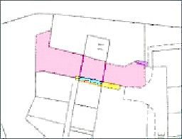
The notes to the Legal Settler will be completed as to any previous registrations or Research Team Notes affecting the land being registered together with details of any other markings shown on the Index Map which may affect the land.
On the First Registration of land where the DIR contains or refers to an earlier writ containing the grant of a specific or other unusual servitude the Legal Settler should be informed whether or not the land over which the servitudes have been granted is already registered and if so the Title Numbers and any Title Plan references applicable to such servitudes.
For Departmental purposes "specific or unusual servitudes" will include the following rights: -
(a) The right of way over land which does not comprise a passageway at the back of house plots on a developed or developing estate.
(b) The right to use drains, the line of which is shown on the plan to the deed.
(c) The right to use a cesspool.
(d) The right to use pipe lines leading to oil storage tanks.
(e) The right to take hot or cold water through defined private pipe lines.
(f) And any other rights of similar nature.
(g) All those granted in conveyances of shop, commercial or industrial premises, or parts of converted houses (split villas) and those granted to gas and electricity boards (in the registration of sub-stations).
Plans Staff will supply plans references for servitudes and rights of way. The Legal Settler may decide that a right cannot be entered on the Title Sheet and this will necessitate the removal of the plans reference from the Title Plan if it has been given prior to his examination.
The Legal Settler should be informed about the reference that has been given. For example -
"The land coloured brown on the plan to deed 5 has been tinted brown on the Title Plan".
Occasionally, servitudes referred to in deeds are ill defined or vague on the deed plans and it is not possible for Plans Section to give either a plans or verbal reference. In these circumstances a note should be made to the Legal Settler explaining the situation.
Servitudes are granted over roadways which have been adopted by the Local Authority or on Developing Estates over roads which are shown as defined on the ground. In these circumstances the Legal Settler should be informed that the roadway has been adopted by the Local Authority or in the case of a Developing Estate the name of the roadway itself may be used to describe the servitude.
The Legal Settler must be informed of all Plans references given on the Title Plan for various areas on the deed plan(s) other than those specifically part of the outright ownership forming the property description. This should be set out clearly in the following manner: -
"References given on Title Plan: -
Drying green coloured green on plan to deed 2 - tinted pink
Bin store coloured brown on plan to deed 2 - tinted brown
Pathway coloured yellow on plan to deed 3 - tinted yellow
Pipeline on plan to deed 7--- blue broken line".
In some instances, references are used for more than one purpose, e.g. an area may be tinted blue and yellow, the blue being the extent of a flat, the blue and yellow being the solum. In this type of situation, it will be appreciated by the Legal Settler that all references are set out irrespective of whether or not the references are already accounted for in the property description.
Additional information required by the Legal Settler: -
(i.) Where plot numbers are quoted for properties that share pro indiviso areas - postal numbers are required where available. If not available, inform the Legal Settler of this.
(ii.) Whether or not building lines affect, particularly whether or not they agree with the position of the building as presently existing. (Remember that changes in road alignment or width may affect the information. The aim here is to reflect the original position on the ground).
(iii.) Any areas or pipelines, said to affect, but in fact do not, hence no reference(s) given.
(iv.) Any other information thought relevant.
8.10.3 Completing The A Property Section
After completing the mapping the Plans Officer will complete the A. Property Section as to:
(i.) interest in which the land is held (see below for further information).
(ii.) the Map Reference
(iii.) the two hectare identifier code; and
(iv.) the Property Description (see below)
The INTEREST to be quoted in the A section of the Title Sheet refers to the type of tenure held by the person or persons named in the B section. It is expressed as the owner's 'relationship' to the interest held: the three most common terms are explained thus: -
(i.) Proprietor: where the subjects are held under Dominium Utile whether they were conveyed by a Disposition or Feu Disposition. Subjects owned by the Crown (H.M. Remembrancer in Scotland) or held under Udal Tenure (Orkney/Shetland) will also be, in effect 'PROPRIETOR'.
(ii.) Tenant: where the subjects are held under a Lease (such relationships here can be complicated, see (iv) and (v) below).
(iii.) Superior: where the subjects are held under Dominium Directum, the proprietorship or Dominium Utile having been feud.
NOTE 1. Where the subjects form land where a portion is feud (therefore referenced by blue edging), the interest will be described as SUPERIOR/PROPRIETOR.
NOTE 2. Where the subjects form Dominium Plenum i.e. they comprise both Dominium Utile and Dominium Directum (in this case the immediate superiority), the interest will be described as PROPRIETOR as, effectively, the interest becomes Dominium Utile because the immediate superior acquires actual occupation of the subjects. There will still be yet a further 'Superior' along the feudal chain. (In practice, the feu or Dominium Utile title is absorbed into the higher interest (Superiority), and the level of proprietorship is one step nearer the Ultimus Haeres (highest interest being the Crown).
8.10.3.1 Map Reference
The MAP REFERENCE to be inserted in the A. Property Section is that which is shown when clicking the MAPBASE Button on the DMS.
Where the land to be registered is a single area of land straddling two or more Map Tiles, only the number of the Map Tile covering the greater area of the property is to be entered on the LRS.
Where the land to be registered consists of two or more separate areas that fall on two or more map tiles the action to be taken is as follows:
(i) If the four-figure reference of all the affected map tiles is the same (e.g. NS4556 NE and NS4556 NW), only the single four-figure reference should be supplied.
(ii) If the affected map tiles include up to five different four figure references, these will be shown thus "Map reference NS 4556/NS 4667/NS 4558/NS 5556/NS 5557".
Note 1: - It should be noted that for each parcel of land in a title straddling two or more Map Tiles, only the map tile covering the greater part of the parcel is to be supplied.
Note 2: In order to avoid any confusion it should be noted that when the Map Reference is added to the field there should be no spaces between any letters or numbers i.e. NT2891NW
8.10.4 Hectare Identifier Code
Where the subjects measure more than two hectares in area (as determined by using the DMS area function) the A Section must reflect the measurement as in the following example -
"Subjects THE MILL, SMITH STREET, ANYTOWN edged red on the Title Plan being 3.8 hectares in measurement on the Ordnance Map"
Note - the area is always rounded to the one decimal place - when the digit to be removed is 5, 6, 7, 8, or 9, round up; when the digit to be removed is 0, 1, 2, 3, or 4, round down.
The area measurement must be entered in the hectare code field in the A Section of the LRS. Again, this should be rounded to one decimal place.
8.10.5 'A' Property Section Precise Extent
The description (always preceded by the word "Subjects") must contain, where available:
(i.) the postal number or house name
(ii.) the street name
(iii.) the local area name (if any)
(iv.) the town name
(v.) postcode
It must also include a reference to the Title Plan and where the registration exceeds two hectares in area, the measurement is quoted.
Where both postal numbers and house names are available preference is given to postal numbers. Postal numbers can only be changed by order of the local authority whereas house names can be changed at the whim of the proprietors and many people on moving house take the house name with them.
Where no postal number is available but a house name is supplied the house name should be used. As to the Title Plan, where the house name is not shown, it is not normally added. If a house name is shown on the print being used (i.e. as shown on the published map), but it is obviously a previous name in that the deeds clearly relate the situation (e.g. "formerly 'The Cottage', now known as 'Apple Cottage' ...."), the property description will reflect the new name, and the old one will be crossed through in blue on the Title Plan. A P98 should also be completed and submitted to Mapbase Maintenance - See Section 18 - Mapbase Maintenance.
Where the subjects involve multiple properties this must be clearly reflected in the 'A' Property Section Description and entered into the LRS following the guidelines laid out in Manuals and Memos - Registration Reference Materials - indexing guidelines - addressable subjects - multiple addresses
The remainder of this section provides guidelines for dealing with subjects, which do not have a full bounding description as, described above - further examples and guidelines can be found in Manuals and Memos - Registration Reference Materials - indexing guidelines - Non addressable subjects
If you are dealing with an application that is not covers in any of the guidelines and require assistance please submit the details including the Title Number trough the Plans Manual Feedback facility. The Plans Manual Team will endeavour to answer your query within 24 hours.
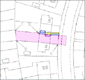
Where neither a postal number nor house name is available the property should be described by relating it to an adjoining or nearby roadway as follows: -
(i.) Where the subjects abut a roadway.
Subjects on the north side of McEWAN STREET, GREENOCK, edged red on the Title Plan.
(ii.) Where the subjects do not abut a roadway.
Subjects lying to the south of RUSSELL STREET, KILMACOLM, edged red on the Title Plan.
(iii.) Where the subjects abut a roadway but the roadway is not named. The description will be related to the nearest towns or villages to which the road, in each direction links e.g.
Subjects on the north west side of the road leading from HOUSTON to KILMACOLM, edged red on the Title Plan.
The labels "from HOUSTON" and "to KILMACOLM" must be added in blue to the Title Plan.
For information on entering details onto the LRS see Manuals and Memos - Registration Reference Materials - indexing guidelines - Non addressable subjects
NOTE 1: At no time should a Ministry of Transport road Classification (e.g. A74) be used as part of the description. Although large-scale re-classification is unlikely, it does happen in small sections of road, such as the construction of a by-pass. The by-pass will take on the road classification of the main route and the old stretch of road will be re-classified. E.g., the stretch of road that goes through Tranent and Musselburgh was part of the A1 trunk road, and was re-classified as the A199 on completion of the by-pass which in turn now forms the new route of the A1. In that example, in the event of any registered properties that had been described in relation to the old road classification, they would therefore be incorrect.
NOTE 2: For clarification where the property can be identified by a house name locality/post town and postcode there is no need to relate the subjects to a roadway, where the roadway is not named. See Manuals and Memos - Registration Reference Materials - indexing guidelines - addressable subjects - House Name/building Name Field
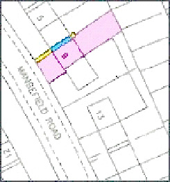
Where there is a garage or land separate from the house plot this should be reflected in the 'A' Property Section as follows:
(a) Subjects 127 ERSKINE ROAD, WEMYSS BAY, PA18 3ZK and garage edged red on the Title Plan.
Or
(b) Subjects 139 ERSKINE ROAD, WEMYSS BAY, PA18 3ZK and land on the south side of DRUMMOND ROAD, WEMYSS BAY, edged red on the Title Plan.
Electricity sub-station sites should be described as follows: -
Subjects being the site of an electricity sub-station on the west side of CARTSBURN ROAD, GREENOCK, edged red on the Title Plan.
In the absence of postal descriptions on Developing Estates, having the Title Sheets of all registered properties showing the same description when describing the subjects in relation to a nearby road is clearly undesirable and could be confusing. In such cases it is acceptable to describe the subjects by means of a plot number as follows
Subjects PLOT 66 VIEWFORTH ESTATE, RENFREW ROAD, INCHINNAN, edged red on the Title Plan.
Where property has been demolished but is referred to in the deeds by its postal description this may be used in the 'A' Property Section as follows:
Subjects on the south side of LONDON ROAD, CLYDEBANK, being the former site of Number 153 LONDON ROAD, edged red on the Title Plan.
Where from the wording in the deeds it can be established that a purchaser is also the proprietor of land adjoining that being registered, the 'A' Property Section description should reflect this as follows:
Subjects at the rear of 50 ROBERTSON STREET, ERSKINE, edged red on the Title Plan.
8.10.6 Tinting Method with No Red Edging
This method of mapping is frequently used where small areas are involved or complex references are required, a red edging would only confuse the situation. It also avoids the need for restrictive notes, to the A. Property Section.
When preparing the A. Property Section entry, it is important to ensure that it refers only to those parts of the subjects which go to make up the exclusive property and does not include shared rights in property, or servitudes which are dealt with as usual by notes to the Legal Settler.
Examples
Excerpt from Deed
|
(FIRST) All and Whole that plot of ground lying to the south of Parkhouse Road, Glasgow in the County of Lanark and for registration purposes within the County of the Barony and Regality of Glasgow coloured red and marked"299" on the plan annexed and executed on the attached plan and (SECOND) All and Whole that plot of ground with the garage thereon lying to the west of the subjects hereby (FIRST) disponed and being coloured purple and marked "299" on the said plan, which plan is demonstrative only and is not taxative; In this instance the other references on the Title Plan relate to rights etc. A. Property Section |
Excerpt from Deed
|
In the First Place ALL and WHOLE that plot of ground containing Two Hundred and Fifty-nine square metres or thereby all as delineated and shown within the boundaries coloured red on the plan annexed as executed as relative hereto; In the Second Place an exclusive right of property in and to that portion of the dwellinghouse aftermentioned known as and forming Number Sixty-two Rylees Crescent, Penilee, Glasgow, in so far as situated at ground level on the area of ground shaded purple on the said plan; and In the Third Place an exclusive right of property in and to that portion of the said dwellinghouse in so far as situated at upper or first floor level on the area of ground coloured yellow on the said plan coloured yellow In this instance the other references on the Title Plan relate to rights etc. A. Property Section |
| Pend Cases | |
Excerpt from Deed
|
ALL and WHOLE that plot of ground or area of ground lying in the Parish and District of Hamilton and County of Lanark extending parts of a square metre or thereby all as the said plot or area of ground is shown delineated red and coloured pink on the plan annexed and executed as relative hereto; In this instance the other references on the Title Plan relate to rights etc. A. Property Section |
Excerpt from Deed
|
ALL and WHOLE that plot of ground or area of ground lying in the Parish and District of Hamilton and County of Lanark extending to One Hundred and eighty four square metres and sixty five decimal or one hundredth parts of a square metre or thereby coloured pink on the plan annexed and executed as relative hereto: together with Clydesdale Avenue, Eddlewood, Hamilton, erected mainly on the said plot or area of ground together with that part of the upper floor thereof erected above the common close aftermentioned as the said part is coloured blue on the said plan annexed as relative hereto In this instance the other references on the Title Plan relate to rights etc. A. Property Section |
Excerpt from Deed
| ALL and WHOLE that plot of ground or area of ground extending to Two Hundred and seventy six point seven square metres or thereby metric measure lying generally on or towards the west side of Jean Armour Terrace, Greenock and shown delineated in red and blue on the plan annexed and executed as relative hereto: In this instance the other references on the Title Plan relate to rights and in respect of the area coloured blue there is reserved to the proprietors of |Seven Jean Armour Terrace, aforesaid and others deriving right from them a heritable and irredeemable servitude right of access. A. Property Section |
Excerpt from Deed
|
(First) ALL and WHOLE the dwellinghouse known as Number Fifty Six Craigflower Road aforesaid, forming the lower flat of the two flats shown delineated and coloured red on the Plan annexed as relative hereto which plan is demonstrative only and is not taxative which two flats form part of the block of eight flats marked "316U" and "323L"
In this instance the other references on the Title Plan relate to rights etc. A. Property Section |
8.10.7 Modern Blocks (Flatted Property)
(Not covering Split villas (converted houses): or Tenement property: or flatted property in Cumbernauld (Special instructions)).
8.10.7.1 General
There are various types of deeds used in conveying flatted property and it is therefore essential to read the relevant deed (whether the DIR or breakaway) carefully before determining the mapping procedure, and subsequently the property description. The two main methods of mapping used are Precise Extent and Site Plan. Both styles may involve one or more colour references, but only those referenced areas dealing with outright ownership will be referred to in the property description; the remaining parts, if any, i.e. pro-indiviso rights, rights of access etc. will be edited in by the Legal Settler based on the information given by plans staff.
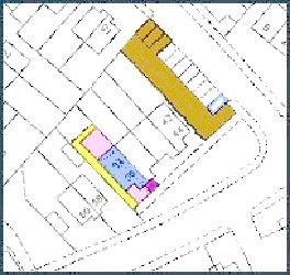
8.10.7.2 Precise Extent (Tinting Method)
Although some earlier registrations may have been completed by red-edging subjects wholly defined by numerous colour references, this is now generally treated as superfluous. Precise extent is therefore synonymous with the tinting method.
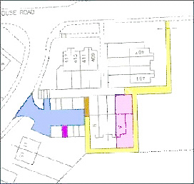
Where relevant deed plans clearly identify each area in which the proprietor has an interest; mapping is completed to show these areas on the Title Plan and the property description will be, for example: -
"Subjects 10 MURROCH CRESCENT, BONHILL, being the lower flatted house tinted blue on the Title Plan, with the areas of garden ground and parking space tinted pink and mauve respectively on the said plan".
The Legal Settler is informed of the yellow and brown colour references.
In instances where the extent of the individual flat is not identified, the above method may be adapted to suit. In all instances the wording in the deed should be reflected in the property section.
NOTE: It is important that the description will follow, wherever practicable, the style of the deed from which it is derived.
8.10.7.3 Site Plan (Other Than Traditional Tenement Buildings)
Although some earlier registrations may have been completed by red-edging subjects wholly defined by numerous colour references, this is now generally treated as superfluous. Precise extent is therefore synonymous with the tinting method.
Where relevant deed plans clearly identify each area in which the proprietor has an interest; mapping is completed to show these areas on the Title Plan and the property description will be, for example: -
"Subjects 10 MURROCH CRESCENT, BONHILL, being the lower flatted house tinted blue on the Title Plan, with the areas of garden ground and parking space tinted pink and mauve respectively on the said plan".
The Legal Settler is informed of the yellow and brown colour references.
In instances where the extent of the individual flat is not identified, the above method may be adapted to suit. In all instances the wording in the deed should be reflected in the property section.
NOTE: It is important that the description will follow, wherever practicable, the style of the deed from which it is derived.
8.10.7.3. Site Plan (Other Than Traditional Tenement Buildings)
This style is used where either none or only some of the constituent parts of the Title (e.g. flat, rights to bin store, drying green etc.) are identified by plans in the deeds. The "steading" is then identified: -
(a) Flat described as to its position in a block identified by one number: -
"Subjects within the land edged red on the Title Plan being the westmost house on the first floor of the Block 26 SMITH COURT, PAISLEY."
(b) Flat described as to its position in a block identified by several numbers (usually linked with one specific number).
"Subjects being the north-west house on the second floor above the ground floor at 26 SMITH COURT, PAISLEY of the Building 22, 24 and 26 SMITH COURT within the land edged red on the Title Plan".
(c) Flat having an individual number within a block itself described as a series of numbers: -
"Subjects 145 MELROSE ROAD, CUMBERNAULD within the land edged red on the Title Plan being the left-hand flat on the first floor above the ground floor of the Block 140 to 150 (even numbers) MELROSE ROAD.
In order to assist the Legal Settler to edit in the rights and pertinents affecting the property, it is desirable to reflect how the building is described in the deeds: therefore insert "Block", "Buildings" or "Tenement" etc. as required.
NOTES
(1) The wording of the deed is always followed when drafting property descriptions, but if the deed describes a flat as being the left-hand or eastmost flat (for example) only "eastmost flat" is included in the property description. Left-hand or right-hand is only used where no compass direction is given. If because of a vague description staff are in any doubt as to whether a flat may already be registered, they must refer to an appropriate senior officer who will take action to obtain a more accurate description of the flat sought to be registered. IT IS ESSENTIAL THAT STAFF CHECK THE DESCRIPTION OF ALL PREVIOUS REGISTRATIONS IN THE STEADING TO ELIMINATE ANY POSSIBILITY OF DOUBLE REGISTRATION. To assist in this, both (e.g.) "left-hand" and "eastmost" should be included in indexing.
(2) In (c) above, note that where block numbers are quoted, and they are not sequential (i.e. 140, 141, 142, 143 etc.) you must state " (even numbers)" or " (odd numbers)" as required.
(N.B. Although some styles of property descriptions may suit both Tenement and non-tenement style property, it is considered helpful to have separate sections, even if some styles are repeated therein. Satisfy yourself in which category your subjects fall as there may be subtle differences in the way the description needs to be formulated).
(i.) The following are examples of property descriptions, where NO PLAN REFERENCES are required and can be adapted, to a certain extent, to fit the situation. It is important to remember that if a description will not fit the main types listed below, there may be problems with the deed itself, and referral should be sought: -
Examples not yet available
(ii.) The following are examples of property descriptions where one or more Plans references are required, and can be adapted to a certain extent to fit the situation. It is important to remember that if a description will not fit the main types listed below, there may be problems with the deed itself, and referral should be sought.
(a) Example REN 15963 -
"Subjects within the land edged red on the Title Plan being the south-eastmost house in the attic flat of the Tenement 89 HOLMSCROFT STREET, GREENOCK, together with the cellar tinted yellow on the said plan".
This Property Description includes only areas that are owned outright: and for which a Title Plan reference has been provided, additional pertinents etc. are covered by the following note to the Legal Settler (e.g. Please edit in additional pertinents and rights from Deed 'X')
(b) Example DMB 953 -
"Subjects 147 ROWAN ROAD, CUMBERNAULD, within the land edged red on the Title Plan being the eastmost house on the first floor above the higher ground level of that part of block 121 to 173 ROWAN ROAD tinted blue on the said plan".
In this Title the steading edged red includes several blocks of flats each flat having an individual number. The block in which the flat is situated is referenced.
(3) - If the deed plan depicts a reference for the solum of the block and this reference is only narrated as being a right in common etc. and is not used to describe the block when describing the exclusive property being sold. Then the A. Property Section should reflect the same and not refer to the reference provided for the solum property except when referring to the right in common to solum.
8.10.7.4 Site Plan Method In Conjunction With A Supplementary Plan
This method is used when the deed plan, normally of a large scale, refers to several areas which will be shown on every deed plan for flats within the block and where only the areas relevant to the case will be referred to either by plans staff in the Description or by Legal Staff in the pertinents and where the detail on the Supplementary Plan is such that it could not be reproduced on the Title Plan.
Example: -
"Subjects within the land edged red on the Title Plan being the northmost house on ground floor of the block 91 DAFFODIL BANK, KILBARCHAN with the garden ground and coal cellar tinted pink and blue respectively on the supplementary plan to the Title Plan".
8.10.8 Tenement Properties
8.10.8.1 General
There are various styles of deeds used in conveying Tenement properties, and it is therefore essential to read the relevant deed (whether the DIR or breakaway) carefully before determining the mapping procedure and subsequently the property description. The mapping style will invariably be site-plan, and apart from the occasional registration of a flat by way of describing the whole plot under various exceptions, the phrase "within the land edged red" will form the key part of the description. The examples given below are guides only, and it must be remembered that where possible the description must follow the terms of the deed. If difficulties arise it must be borne in mind that the difficulty may be with the deed itself, so if in doubt, refer.
8.10.8.2 Flats (i.e. as opposed to shop premises)
(a) Flats with one number shown for the Tenement
"Subjects within the land edged red on the Title Plan being the westmost house on the second floor of the Tenement 12 MAIN STREET, PAISLEY".
(b) Flats within a Tenement/Block covered by several street numbers
When a tenement/block consists of several numbered properties e.g. 1, 3 and 5 HIGH STREET, RENFREW and the deed states that entry or access is by a specific close or entrance, or it is obvious that the street number is used by several flats, the property description will be similar to: -
"Subjects being the northmost house on the third floor above the ground floor at 3 HIGH STREET, RENFREW of the Tenement 1, 3 and 5 HIGH STREET, within the land edged red on the Title Plan".
N.B. Where a tenement is numbered to two streets, the description will also reflect this, e.g.
"Subjects being the northmost house on the third floor above the ground floor at 3 HIGH STREET, RENFREW of the Tenement 1, 3 and 5 HIGH STREET and 24 PARK ROAD within the land edged red on the Title Plan".
Note 1: Postal descriptions given for the Tenement property should reflect the narrative of the title deeds. Where the deed remains silent on the postal numbers of the Tenement then the tenement should not be referred to in the A Property Section. The legal settler will include it in the terms of the narrative when editing the rights and burdens if required.
For example
Narrative of Deed
"……..the flatted dwelling house entering by the common passage and stair number 35 LAURISTON GARDENS, EDINBURGH in the County of Midlothian being the northmost house on the first floor of the tenement of which it forms part……."
A Property Section
Subjects within the land edged red on the Title Plan being the northmost house on the first flat above the ground flat at 35 LAURISTON GARDENS, EDINBURGH, EH3 9HJ,
(c) Flats with individual numbers
e.g. for main door flats in traditional tenements. In this example numbers 1 and 5 are main door flats and number 3 is the common close or entrance: -
Subjects 1 HIGH STREET, RENFREW within the land edged red on the Title Plan, being the eastmost flat on the ground floor of the Tenement 1, 3 and 5 HIGH STREET.
See Note 1 in section 8.10.8.2(b) above.
(d) (i) A. Property Section Schedules for Applications involving two or more flats in same Tenement Steading
When two or more tenement flats are being registered under one application to describe them in the normal manner in the A. Property Section can be very confusing, In these instances the descriptions of the properties are prepared for the A. Property Section in schedule form.
TITLE PLAN
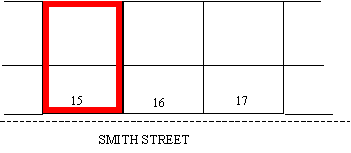
Where a schedule is used the A. Property Section will be prepared using the following style: -
"Subjects at 15 SMITH STREET GREENOCK PA15 1NH within the land edged red on the Title Plan more particularly described in the schedule below"
Then follows the schedule of properties of which the following is an example:
| Entry No. | Subjects |
| 1 | westmost flat on the ground floor at 15 SMITH STREET |
| 2 | westmost flat on the first floor at 15 SMITH STREET |
| 3 | westmost flat on the second floor at 15 SMITH STREET |
To enter the schedule on the LRS follow instructions on LRS Manual - A Property Section - Schedules. As there is no specific schedule for this opt for schedule of exceptions and in the header text field type in "schedule referred to" and then complete the appropriate fields to compile the schedule as shown in examples
(d) (ii) A. Property Sections for Applications involving two or more flats in more than one Tenement Steading.
Due to the limitations of the LRS a schedule in this instance is impractical as it does not allow the legal settler to edit in the rights pertaining to each Tenement and flat. Therefore the A. Property Section should be completed without using a schedule using the following style.
TITLE PLAN
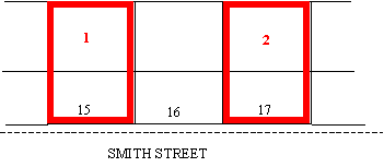
Subjects within the land edged red on the Title Plan being (1) the westmost flat on the top floor of the Tenement 15 SMITH STREET, GREENOCK, PA15 1NH edged and numbered one in red in the said Plan, (2) the eastmost flat on the first floor of the said Tenement 15 SMITH STREET, (3) the eastmost flat on the second floor of the said Tenement 15 SMITH STREET, (4) the westmost flat on the first floor of the Tenement 17 SMITH STREET, GREENOCK, PA15 1NH, and (5) the westmost flat on the second floor of the said Tenement 17 SMITH STREET
(e) Description by way of exception
The last flat sold out of a tenement is frequently described as being the whole steading under exception of all the previous flats sold. This method of describing the remainder is often preferred to a particular description of the remainder because it ensures that the seller is not inadvertently left with the responsibility for a part of the original subjects, which may have been overlooked, in the particular description.
The Title Plan is mapped, using the precise extent method, by red edging the whole of the steading extent on the Title Plan as described in the extent deeds and instructing the legal settler to provide a schedule of exceptions in the A Property Section. The manner in which such a conveyance is reflected in the A. Property Section depends on the nature of the subjects
Commonly, the location of the flatted property is not specified and could only be ascertained by the process of elimination. For the avoidance of doubt this is not necessary or desirable and the Title Sheet must reflect the intention of the deed and accordingly the A Property Section should follow the following format
"Subjects 26 LONDON ROAD, GLASGOW G1 5NB edged red on the Title Plan under exception of the parts specified in the Schedule of Exceptions below".
Sometimes the deed will also identify the location of the last house, if this is the case this information will be included in the description but will not be used as the description on its own. For example
"Subjects being the westmost house on the first floor above the ground floor of the Tenement 26 LONDON ROAD, GLASGOW, G1 5NB comprising the land edged red on the Title Plan under exception of the parts specified in the Schedule of Exceptions below".
NOTE 1: The Legal Settler should be specifically informed that mapping and the subsequent style of property description has been completed to reflect the deed (s) and requested to insert the schedule of exceptions.
In tenements, it is generally accepted that, no plans references are given when the exception deeds refer to plans, due to the fact that the number of exceptions normally involved would make the Title Plan cumbersome and cluttered. Instead the legal settler will refer to the subjects verbally in the schedule of exceptions. If in doubt as to whether references are required refer to the Legal Settler (Also See Split Villas).
NOTE 2: Where the subjects prior to the exceptions include postal addresses that are then to be excepted, these postal addresses must be included in the A. Property Section prior to the exceptions
8.10.8.3 Shops
(a) No plan
The description may be as full as that usually given for flatted property, and will normally have an exclusive postal number.
"Subjects 259 JOHNSTONE STREET, PAISLEY within the land edged red on the Title Plan being the westmost ground floor shop of the Tenement 253 to 259 (odd numbers) JOHNSTON STREET".
If a basement floor is also involved, this will normally follow "shop" above unless the style of the description in the deed prohibits this.
Quite often, the description in the deed can be very vague, not even mentioning that the shop is on the ground floor: in its vaguest form, the description may have to be completed as follows: -
"Subjects 259 JOHNSTONE STREET, PAISLEY within the land edged red on the Title Plan being shop premises of the Tenement 253-259 (odd numbers) JOHNSTON STREET".
8.10.8.4 Where Plans References Are Required
(i.) Accommodated on Title Plan
(a) Example REN 15963
The property description includes only areas that are owned outright; pertinents, rights and pro indiviso areas are covered by the notes to the Legal Settler who edits them in to the A Section.
"Subjects within the land edged red on the Title Plan being the south eastmost house in the attic flat of the tenement 89 HOLMSCROFT STREET, GREENOCK, together with the cellar tinted yellow on the said plan"
(b) "Subjects 259 JOHNSTONE STREET, PAISLEY within the land edged red on the Title Plan being the ground floor shop premises tinted blue on the said plan of the tenement 253 to 259 (odd numbers) JOHNSTON STREET with the cellar and bin store tinted pink and yellow respectively on the said plan".
(ii.) Where a supplementary plan is required
Example REN 5607
Subjects within the land edged red on the Title Plan being the eastmost house on the middle flat of the Tenement 19 EASTWALD BANK, MILLIKEN PARK, KILBARCHAN, with the garden ground and coal cellar tinted pink and blue respectively on the supplementary plan to the Title Plan.
8.10.8.5 One Flat Plus Part Of Another, Merged On Renovation And A Plan Is Available For The Latter.
This usually occurs where a middle flat is split between the (e.g.) east and west-most flats on upper floors of a tenement building. Normally mapping is completed on a straight forward site-plan style and no reference is given for the newly acquired portion as this would be misleading and inappropriate. The property description ought to be that of the larger, original flat, as the new, lesser, portion is absorbed into the larger and no mention is necessary. If the deed suggests anything else, refer to a senior officer.
8.10.8.6 Where Only The Solum Is Identifiable
This occurs, albeit rarely, where after all usual steps have been taken, the whole steading cannot be identified and only the solum of the Tenement is edged red. As long as there are no other points arising, the particular flat, or shop can be described in the manner described previously.
8.10.9 Split Villa Property (Converted Building)
Where the description is positive, e.g. the DIR, or deed referred to therein positively describes the property as "upper flat of the building" or 42A SMITH ROAD being the "lower flat of the building" etc., the description can be completed in that manner. However where the property is described as a steading or plot of ground under exception of one or more parts, mapping and its accompanying property description must reflect the terms of the deed.
It may in some circumstances be prudent to consult the Legal Settler before formulating both style of mapping and the property description. However, depending on the particular circumstances, the description will follow one of the following examples.
(i.) Subjects BAYVIEW, WEMYSS BAY edged red on the Title Plan under exception of the parts specified in the Schedule of Exceptions below.
(ii.) Subjects being the upper flatted dwellinghouse at BAYVIEW, WEMYSS BAY, comprising the land edged red on the Title Plan, under exception of the parts specified in the Schedule of Exceptions below.
NOTE: The Legal Settler should be specifically informed that mapping and the subsequent style of property description has been completed to reflect the deed(s), and he/she will be invited to formulate the schedule.
8.10.10 Property Descriptions - Instances Of Legal Staff Involvement
This section formerly dealt with interests relating to BARONY TITLE and GROUND ANNUAL which, following feudal abolition, are no longer registrable interests.
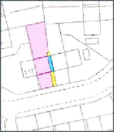
8.10.11 Property Description - Multiple Breakaway Deeds
It is sometimes the case that the DIR refers to more than one breakaway deed. For example, the hous may be described in one deed and the garage in another. In such cases, the Plans Officer should ensure that the property description is created in such a way that allows the Legal Officer to edit in the appropriate rights for each of the deeds at the appropriate place. The following is a simple example -
"Subjects (1) 14 SMITH STREET, ANYTOWN tinted pink on the Title Plan and (2) the garage tinted blue on the said Plan"
The Legal Settler will then be able to edit in the appropriate rights for each part of the property. It follows from the above example that the Title Plan will be mapped using tinting method showing separate references for the separate deeds.
8.10.12 Property Description – Leases of Sporting Rights
Applications which are leases of either sporting / shooting rights should follow the terms of the deed as much as possible. Due to the varied nature of the ways these are narrated in the deeds there is no exact Property Section style, suffice to say that the Property Section must at a minimum reflect that the subjects are the sporting / shooting rights, and not a lease of the ground itself.
Any queries should be passed to a Plans HEO / Senior Caseworker for advice.
N.b. If the property description in the lease narrates trout fishing the Property Section should be silent with regard to this. Leases of Salmon Fishing rights involve specialities and complexities and are dealt with in Section 8.2.31
Related content
*
This is the registration manual for 1979 casework.
Do not under any circumstances use the information here when settling 2012 casework. This resource has been archived and is no longer being updated. As such, it contains many broken links. Much of the information contained here is obsolete or superseded.
*
The Manual is an internal document intended for RoS staff only. The information in the Manual does not constitute legal or professional advice and RoS cannot accept any liability for actions arising from its use.
Using this website requires you to accept cookies. More information on cookies.