This is the registration manual for 1979 casework.
Do not under any circumstances use the information here when settling 2012 casework. This resource has been archived and is no longer being updated. As such, it contains many broken links. Much of the information contained here is obsolete or superseded.
P8.2 PREPARATION OF TITLE PLAN
- Former user (Deleted)
- Admin2 (Unlicensed)
8.2.1 Introduction
Prior to the introduction of R.O.T., reliance was placed mainly on verbal descriptions (sometimes supported by deed Plans of variable quality) for the identification of land in title deeds which were recorded in the Register of Sasines. One of the main benefits of registered land is by a reference to a clear and reliable plan (the Title Plan).
The position and extent of the land in title deeds is still described in a variety of ways. It may be identified by verbal description without reference to a plan or it may be described by reference to a plan or both. The quality and accuracy of deed plans cannot always be relied upon so that the extent of the land to be registered is not always clear.
Section 6(1)(a) of the Land Registration (Scotland) Act 1979 states that the Ordnance Map shall be the basis for all registered descriptions of land.
The Land Registration (Scotland) Act 1979, Section 4(2)(a) states that "an application for registration shall not be accepted by the Keeper if it relates to land which is not sufficiently described to enable him to identify it by reference to the Ordnance Map".
8.2.2 Accuracy and Quality
The main function of Plans Section is primarily to check Title and then subsequently prepare Title Plans which accurately portray the extent and position of the land being registered.
With the large scale Ordnance Maps used in the Agency a satisfactory degree of accuracy is possible, providing that care is taken in reading the deeds and associated plans, and adding information as necessary to the Title Plan.
All plans staff should ensure that plans prepared in the Agency are drawn to a satisfactory standard. The Senior Plans Advisor has overall responsibility for seeing that mapping standards are maintained and will be particularly concerned with the standard of revision work and the incidence of any reported plans errors.
8.2.3 Use of the Ordnance Map
The Title Plan will be based on the Ordnance Map and will be prepared on a print from the DMS. The scales of the Ordnance Maps currently used for the preparation of Title Plans are:
(a) 1/1250 - used in urban areas.
(b) 1/2500 - used in rural or undeveloped areas where the 1/1250 is not published.
(c) 1/10,000 - used in extensive undeveloped areas e.g. mountain or moorland areas.
NB. As a general rule the Title Plan should be printed at the relevant base scale. However due consideration should be given to the aesthetics and economic practicalities of the scale of the Title Plan and if necessary the Title Plan can be printed at a higher/lower scale. However it must be borne in mind that printing at a higher scale can enhance any discrepancies which may exist with the map detail and/or mapping and that vital boundary information may be lost when reducing the scale of the Title Plan (e.g. some double features on 1/1250 are lost at 1/10000 scale) so if in doubt, refer to a senior officer.
Whatever scale of map is used for the Title Plan, enlargements of particular features of importance are added when required. See 8.2.22
8.2.4 Mapping the Title Plan
It is the responsibility of the Plans Settler to prepare the Title Plan using an extract of the latest available Ordnance Map of the appropriate scale and basing the registered extent on the information supplied with the First Registration Application. In some instances it will be necessary for inspections or surveys to be carried out, requisitions raised, or enquiries made to determine the extent for registration before mapping can be completed.
The preparation of the Title Plan will normally proceed without specific instructions.
On receipt of any Application, one of the essential jobs prior to mapping is checking the Index Layer to see if: -
- A Research Area Note affects
- A Tree Preservation Order affects
- Prior Registration exists
- Back-up files are available (for guidance regarding styles, extent etc),
- "Developed on the ground" procedure has been adopted
- The subjects form part of a scheme title Or
- Any other notes on the Index layer
It is also important that if there is any delay in mapping the application that the Index Layer in checked again to ensure there has be no changes to existing data or further application idented or mapped that would affect you current application.
If a Research Area Note affects, additional notes regarding the preparation of the Title Plan and references required thereon may be included in the case notes and to which adherence should be strictly applied. In any case of doubt or where it is thought the instructions do not fit the current application the case should be referred to the appropriate support officer for consideration. It is important that where it is discovered that an area does not fall wholly within a Research Area, and the deeds suggest that it should, the case must be referred.
In the preparation of the Title Plan, it is of the utmost importance that careful attention is paid to the boundaries of all adjoining registrations, particularly where these are plotted. It is essential to inspect adjoining Titles. Remember too, that supplementary plans may have been used. It is also important that if there is any delay in mapping the application that the Index Layer is checked again to ensure there has been no change to existing data or further applications idented or mapped that would affect your current application.
When the deeds lodged with a First Registration describe the land verbally without reference to a plan, the Title Plan may be prepared from this verbal description only when it is unambiguous (a full bounding description), and the property is clearly identified with most, if not all, boundaries defined on the Ordnance map. Where, for example, one flank boundary is not defined on the Ordnance Map, it can be plotted as long as it is established beyond doubt that the other flank boundary is the one referred to in the deed(s). Remember to make use of the County Series Map which may shed light on the situation and may even show the position of boundaries referred to in the deeds but which are no longer on the ground. The unreliability of out-of-date Ordnance Maps and the possibility of the duplication of property descriptions must always be borne in mind. If any doubt arises, the case should be referred to a senior member of staff for guidance.
If farm property or a country estate is involved the deed may describe the land both by reference to a plan and by reference to parcel numbers and areas. These must be checked one against the other and against the parcel numbers on the County Series or National Grid Map remembering that the latter may be of a different edition from that on which the deed is based and may therefore show different parcel numbers and areas. (It is fairly common to find that the deed referred to for extent in this manner is only an extract copy with no plan attached (pre- 1934 being the date of the introduction of photo- copying in the Registers of Scotland) and the verbal description has to be relied upon. If the relevant edition of the map is not held in the Agency, a photocopy may be obtained from the National Library of Scotland."The preparation of the Title Plan, for cases which have been referred to senior staff, will follow at a later stage after the matter for which they were referred has been dealt with and written instructions have been given by the appropriate officer, which should be signed and dated.
The Plans Settler will prepare the Title Plan (with or without specific instruction depending on the case) by defining the extent of the land to be registered either by a red edging or a coloured tint, adding stamps which are necessary. The subjects will be automatically indexed on the Index layer, and the A property section along with any appropriate notes to Legal Staff will be completed. More detailed notes regarding these procedures are detailed later in this section.
8.2.5 Additional Copies of the Title Plan
Legal Staff will requisition additional copies of the Title Plan from Plans Staff if the title is held by joint proprietors and the applicants request additional copies of the Land Certificate.
8.2.6 Determination of Extent
The Agency has to accept a wide variety of plans and descriptions of land sought to be registered but aims to provide official plans which are reliable and indicate to scale the position and extent of the land in relation to the physical features which exist on the ground.
When the boundaries of the land shown on a deed plan on which an Application for registration is based conform with the physical features shown on the Ordnance Map the mapping of the Title Plan is completed on this basis (i.e. "as defined" on the map).
In cases where the boundaries are not shown on the Ordnance Map the boundaries of the property may be plotted from the deed plan provided:
- The deed plan is well drawn and unambiguous.
- The position of the property can be set up by figured dimensions given in the deeds or accurately co-ordinated with the existing Ordnance Map detail.
- The extent, where plotted, does not include land which appears from the Ordnance Map to be in the possession or occupation of another proprietor (unless it is clear from the deeds that the other proprietor has sold the land to the applicant or his predecessor).
- It is not necessary to have a survey to obtain up-to-date revision.
- The extent included in any adjoining Title Plan has been carefully inspected and it is found that no overlap of title boundaries will result.
In cases where the boundaries have been plotted on to the Title Plan from the deed plan (except where it would seem clear that no physical boundary is ever likely to exist e.g. open plan development) the Plotted Boundaries Stamp should be inserted on the Title Plan -
"THE BOUNDARIES SHOWN BY DOTTED LINES HAVE BEEN PLOTTED FROM THE DEEDS. PHYSICAL BOUNDARIES WILL BE INDICATED AFTER THEIR DELINEATION ON THE ORDNANCE MAP".
Where there are no physical features defining the boundaries of the land, the extent of the land to be included in the Title Plan is normally governed by the deed plan on which the registration is based.
In any dispute concerning boundaries of registered properties which involves the Agency, the parties will invariably refer to the deed and/or plans on which the registration was based and should the dispute go to court these documents and plans (or Extracts or Office Copies) will be produced. To avoid adverse criticism of the Agency it is essential that any material differences between the boundaries indicated on the Title Plan and those on the deeds, should be capable of a rational explanation and are the outcome of considered action by the plans staff and, where necessary, in consultation with the legal settler. It is important that all relevant documentation relating to decisions taken are either recorded on the micro- fiche or stored in the casenotes and that any departmental correspondence is neat and business like in content and presentation.
8.2.6.1 Monochrome Plans
There will be a number of cases where the original deed plan is not submitted with the application but a monochrome copy is. Often the narrative of the deed will refer to various colour references shown on the deed plan. In the majority of cases the Plans Settler will be able to ascertain which areas are those being referred to in the deed by the type of shading used, making use of any textual references on the plan or by utilising the Title Plans for previous registrations, especially in the case of Tenement steadings
However in some circumstances this will not always be feasible. In these instances the following procedure should be adopted (if you are dealing with a reference to a servitude please refer to Section 8.9.6.4)
Is the original deed or a duplicate plan recorded in the Books of Council and Session. If the answer is YES the order a colour copy from the Record Office using a L32 copy deed request form.
If the answer is NO then a requisition will have to be sent to the submitting agent explaining that the deed refers to various colours on the plan, which cannot be distinguished from the monochrome copy deed submitted with the application. Therefore could s/he please attempt to trace the original and submit it or provide a certified copy of the original?
If however the agent draws a blank the case should be referred to a Plan's RO1 who in conjunction with the appropriate legal settler will decide the best way forward. It may be possible to process the application using a verbal reference to the areas in question especially if the Title is to be mapped using site plan method. The other option available would be to request the submitting agent along with his clients and where possible the sellers to colour up the deed plan to the best of their knowledge from the position on the ground and docquet it accordingly.
With both of the above options the possibility of exclusion of indemnity on the extents of the areas in question must be considered.
8.2.7 Land Adjoining Access Ways
Instances occur on First Registration and on the Transfer of Part of a registered title where the land to be included in a new title adjoins or is adjacent to a road or way or strip of land required to give access to land at the back. It may not be immediately clear from the Ordnance Map or from the documents lodged that the strip of land is intended for use as an access way. Unless special care is exercised when registering land adjacent to such access ways, a situation may be created whereby the planned use (or the development) of the back land cannot proceed because of an encroachment on the land intended as a means of access to it.
An example of the situation described above can occur following development along a road frontage, where a builder has used land for each or some of the plots a little in excess of the width conveyed or transferred. The cumulative effect of these small discrepancies may cause an encroachment of an access way and thus prevent the planned development of back land and may involve the Agency in a serious claim on the indemnity fund. Similarly, the registration of plots with a greater depth than that conveyed could affect the width of an access way running along the backs of adjoining properties.
In the circumstances described above it is imperative that the dimensions and scaling of the plans in the documents lodged are checked carefully and that the evidence of any "running dimensions" thrown up by previous registrations or surveys is considered. It is important not to accept too easily boundaries "as fenced" but to develop an attitude of mind which gives thought not only to what land is to be included in the new title, but also to the land remaining which may be required for use as an access way.
8.2.8 Dedication of Land For a Public Highway
Where the Deed Inducing Registration or an earlier disposition makes reference to a dedication of land for a public highway and there is a plan which shows clearly the land affected and it is evident from the Ordnance Map that the land in question
(a) still forms part of the property:
mapping will be completed to include the land, a plan reference will be given and the Legal Settler informed so that a suitable entry can be made on the Title Sheet.
(b) forms part of the highway:
mapping will be completed to exclude the land and the Legal Settler informed accordingly.
8.2.9 Half Roadway
Where an Application for First Registration includes half of the roadway within the subjects sought to be included in the Title, mapping should be completed to include it within the red edging on the Title Plan, as long as there are no instructions in the Index Layer to the contrary (e.g. knowledge of a GVD/CPO for road-widening, the existence of which may not be revealed in the application).
Where a reference is made to a 'Dedication of Land for a Public Highway', other considerations may arise.
8.2.10 Railway Property and Land Adjoining
In many instances when a First Registration is lodged the subjects of which adjoin railway property a statement is found in the deeds in the following form: -
"... taken along a line parallel to and 1'.6". westwards from an existing fence". When this or a similar statement is identified care must be taken both with the indexing and the mapping of the case.
N.B. The distance mentioned is 1'.6". as that is the usual one quoted, but should it be 3'.0". or 5'.0". or some measurement about a metre or over, the boundary can be indicated on the Title Plan by plotting, the dimension shown and a precise extent indexed on the Index Layer. Therefore, in general the following applies to aforementioned narrower strips of land.
Mapping on the Title Plan will be completed to reflect the information on the deed plan, i.e. to include up to the railway boundary. The boundary concerned will be lettered thereon and a note in the following terms added to the A. Property Section and casenotes (including, to comply with the Units of Measurements Directive 1989 (89/617/EEC) the metric equivalent): -
"NOTE: - The boundary of this title lettered A-B on the Title Plan is 0.45m(1'.6"). from the outer face of the railway fence".
Care must be taken to define the boundary in the note in the terms quoted in the deed subject to the said metrication directive.
A note should also be added to the DMS Maintain Title Details which can then be viewed through the DMS casenotes on an Index Map search.
When mapping railway property or land adjoining the Plans Settler must always check the adjoining property case notes, where registered, and the LRS to see if there is a railway property boundary note thus ensuing that no competing is created.
If a competing title exists this should be referred through the normal referral channel.
8.2.11 Plotting Undefined Extents
When a Title Plan is prepared by plotting the boundaries of the land from a deed plan before the development has been completed or recorded by survey, care must always be taken to show sufficient detail on the Title Plan. An isolated and dotted rectangle on a dotted roadway is unsatisfactory. The property should be linked with sufficient adjacent development (or proposed development) so that, by picture, as well as by scaling, it can be readily identifiable.
Please note that in Developing Parent Titles, the practice is usually to obtain a survey update rather than plot from deed plans. However, consideration can be given to plotting all units in a small estate, or after receipt of survey information over part of the development, plotting the remaining units as long as there is no conflicting information on the various deed-plans.
Where for example a very short line of frontage to a particular plot is set up by plotting back from and parallel to the edge of the carriageway, misunderstanding can occur, giving rise to unnecessary correspondence questioning the position of the frontage and access to the land etc. Such misunderstandings can be avoided if a reasonable length of the general frontage line is shown on the Title Plan.
When pertinents such as garages, storage spaces etc., are shown on a deed plan in (say) a developing estate, they are often grouped together in blocks. Where it is necessary to show them on the Title Plan by plotting, sufficient detail should be provided to indicate clearly which garage or space, in relation to the others in the block is included in the title, that is, all the garages, storage spaces etc., should be plotted on both the Title Plan and the Index Layer.
The points referred to above are illustrated in diagrams 1,2 and 3 following and although they are elementary mapping rules they are too often overlooked. All Plans Staff should ensure that mapping work of this kind is not allowed to fall below the required standard.
The three diagrams depict part of a deed plan and two methods of preparing the Title Plan from it. Diagram No.3 showing a little extra detail is altogether better because it completes the picture, but note that only a few additional lines are required to do this.
Diagram No.1
The property, with garage, as shown on the deed plan and the estate plan.
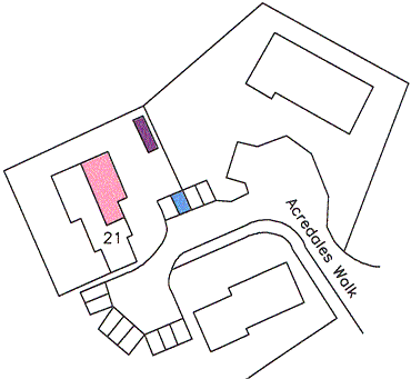
Diagram No.2
The outline of the plot showing too little detail to provide an intelligible plan.
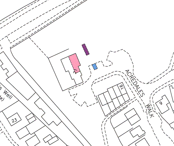
Diagram No.3
A few additional lines provided at plotting stage makes a more satisfactory and informative plan.
These illustrations show an isolated example but it should be borne in mind and the principle generally applies to the preparation of plans of this kind. Plans prepared in the manner of Diagram 2 are unsatisfactory and should not be used.
8.2.12 Dimensions
Where no physical boundaries or markers exist on the ground, Plans Staff will, in certain cases, show figured dimensions on the Title Plan. In specific cases, if staff are unsure whether dimensions should be shown or not, they must refer to their technical referee for guidance. These dimensions will be taken from the deed (subject to the metrication directive – See Metrication) and will govern the extent of the undefined land or right of way and, normally, will also tie its position to adjacent physical features shown on the Ordnance Map. It should be noted that the mere addition of dimensions does not fix the boundaries.
Dimensions should not be added to the Title Plan to show the position of a boundary which is defined on the Ordnance Map or where a plotted boundary is simply a prolongation of detail which is defined on the Ordnance Map.
With regard to quoted dimensions, the following notes should be taken into account
- On all new plans attached to deeds lodged for registration, only metric measurements will be acceptable (Units of Measurements Directive 1989 (89/617/EEC)) which took effect on 1 Oct. 1995.
Does not apply to the usage of ‘acres’ which will continue, officially, for the foreseeable future.
- Imperial units can be used (if necessary) as supplementary indicators to metric units provided the metric measurement is expressed first and the imperial measurement is not more prominent than the metric measurement.
- Metric linear dimensions shown on Title Plans should be shown in the following manner: 23•25m
- Where a dimension in metres containing more than two places of decimals is shown on a deed plan this will be brought forward on to the Title Plan correct to two places of decimals; with that exception the Title Plan should follow the dimension as shown on the deed plan. For example, 23 m or 23•00 m on a deed plan will be brought forward on to the Title Plan as they stand; 23 m should not be interpreted as 23•000 m, and similarly 23•00 m should not be shown as 23 m.
- Where a deed plan expresses a dimension in millimetres the dimensions will be re-expressed on the Title Plan in the form of metres and decimal parts of a metre. For example 10 m 27 mm must be shown as 10•27 m. Similarly 895 mm must be shown as 0•89 m. A dimension of one metre precisely should be shown on the Title Plan as 1 m and a dimension of less than 1 metre should be shown, for example, as 0•25 m.
8.2.13 Referencing the Registered Extent
Plans staff are responsible for the accuracy of delineation and methods of depiction of subjects on the Title Plan and the consequent style of completion of the A. Property Section of the Title Sheet with regard to those subjects exclusively owned by the Proprietor. When selecting the appropriate method, Plans staff must take into account the likely requirements of the Legal Settler.
If any doubt arises as to the best method of depiction (mapping style) of the subjects on the Title Plan, guidance should be sought, if thought necessary, with the Legal Settler to ensure that no problems are created for them when entries are made in the Title Sheet. Should a Legal Settler disagree with a method adopted to complete the mapping and the consequent A. Property Section entry, then the case will be referred to an appropriate technical referee who will liase with the appropriate Plans officer to resolve the matter.
There are four basic methods which are used to define and describe the subjects being registered. The mapping methods are described below with general instructions and examples of usage more in-depth procedures and relevant guidelines for property descriptions are covered elsewhere in the manual under specific property types. The needs of the Legal Settler must be remembered when choosing the following methods.
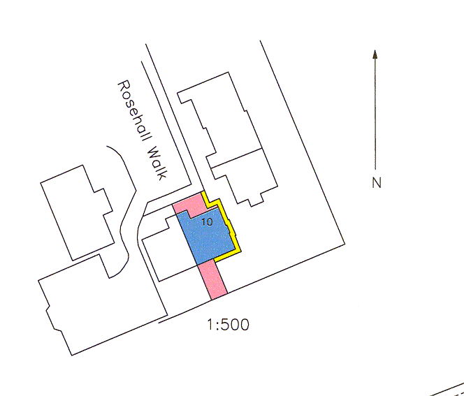
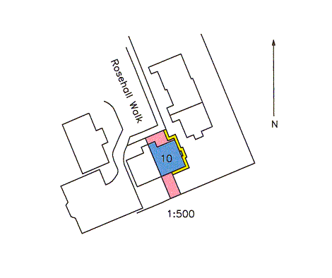
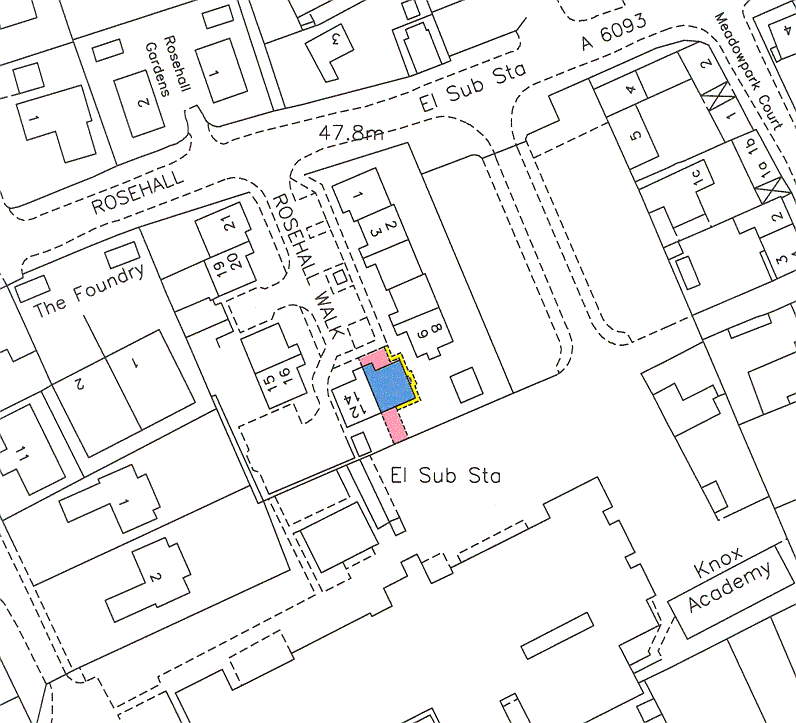
8.2.13.1 Precise Extent — by Red Edging
Where the property is fully defined and identifiable on the Ordnance Map, the extent is edged red on the Title Plan. As the type of property that is so defined includes detached and semi-detached urban properties and rural farm land areas, it can be seen that this method will be used in the majority of cases. The inclusion of pro-indiviso shares or rights in common in paths etc should be mapped using Precise Extent - by tinting method. It should be noted that if references are only required for burdens or rights of access this mapping style may be used
In rare instances where a title is made up of numerous portions all of which require separate references, edging and numbering in red those separate portions may be adopted (This may be linked with a schedule prepared by Legal Staff for the A property section).
Where the title will require separate burdens references that cover the whole of the subjects the red edge is really superfluous therefore it may make sense to map the subjects using tinting method. However if a red edge has been used in the mapping of prior titles on an estate or Research Area for continuity on the DMS and Registers Direct should be continued to be used in future titles
Only in exceptional circumstances should the red edging follow the outer side of the external boundaries of the land. External red edging is usually used where internal edging will obliterate a tinting reference, or where the edging on either side of a narrow strip of land will meet.
The method can also be used where identifiable parts of buildings are included in, or excluded from the land being registered, but take care that the method does not make the Legal Settler's task of editing the rest of the A. Property Section more difficult should the deeds contain additional rights and burdens exercisable by others over the subjects being registered.
8.2.13.2 Island Site
Where land in a title completely surrounds an 'island site' which is not included in the registration, the excluded land is tinted green on the Title Plan. Because the land is described in the Title Sheet as that edged red on the Title Plan it is required that the island site is also edged red. The red edging will be applied on the side of the feature defining the island site i.e. the opposite side from the green tint. Should the external red-edging method have been adopted, the red edging will be applied to the green tint side of the feature defining the island site.
The following explanatory notes are required:
(i.) To the Title Plan (stamp available)
NOTE: The Land Tinted Green Hereon Is Not Included In This Title
(ii.) To the 'A' Property Section Notes
NOTE: The Land Tinted Green on the Title Plan is not included in this Title
N.B. Picklist option is available in the property notes on LRS.
Where it is necessary to bring forward the Parent Title extent, that features an island site, a Transfer of Part Title Plan, the following explanatory notes are required:
(i) To the Title Plan
NOTE: The land tinted green on the Title Plan is not included in the land edged red
(ii) To th A. Property Section Notes
NOTE: The land tinted green on the Title Plan is not included in the land edged red
8.2.13.3 Precise Extent by Tinting Method
Where the property being registered comprises several definable portions, i.e. a house plot with rights in common to pathways, open areas etc or flatted properties where all rights are definable, the usage of the usual red-edging method would at best be cumbersome and at worse confusing. The various areas involved are best depicted by the use of separate tints and, if necessary, also edgings and or hatchings. The procedure is known as the Tinting Method.
The tinting method is also particularly useful in that it avoids the necessity to add restrictive notes to the A. Property Description and Legal editing for the Title Sheet is made easier as it allows the various rights etc. to be 'copied' with the minimum of alteration.
Other instances where the Tinting method is preferable include:
(i.) Registrations of very small areas (or including small areas requiring a plans reference) which would be obscured by red edging.
(ii.) Where the use of red edging would result in numerous island sites.
If using tinting method and there are island sites within the extent of the subjects being registered, there is no requirement for the island sites to be tinted green as the A Section is a positive description, e.g. tinted pink on the Title Plan. The island sites are plotted and filled with the white tint, taking care when printing to check that the white tint polygons sit on top of the references for the subjects being registered. Where possible, the extent of the tint reference for the subjects being registered should be plotted around island site(s) negating the need for a white tint polygon to sit on top.
(iii.) Where the style of the deed plan requires that the Title Plan follows the style of the deed plan on which it is based to avoid either losing the intention of the deed or unacceptably enhancing the original intention.
(iv.) Where the title is covered by burdens references and the red edging is superfluous
Difficulties can arise with tinting method due to the complexity of the references which might be required and where additional references are required for burdens. Even if there are sufficient coloured tints edgings etc. available, a confusing picture may result. Consideration may have to be given to either:
Choosing the red edging method where possible, ensuring confusion does not arise and detail hidden or
Using edging (say brown) and numbering for the burdens references over the top of the property references or
Preparing a second plan as a supplementary plan showing the burdens references. This would be achieved by applying tints, hatchings etc. or edging and numbering those areas as far as they form the composite area being registered, including both exclusive and shared areas.
Using an inset plan
8.2.13.4 Site Plan
This method is particularly useful when dealing with Tenement and some other types of flatted property where the Title Deeds rely on verbal descriptions to define the extent of flats and their pertinents within a defined area or "steading" of ground. Frequently, however, deeds may define some parts such as garden ground, coal cellars, even the flat or shop itself; these types of applications are dealt elsewhere, here we are concerned with those applications where all individual components of the Title are described only.
Once the steading of ground, within which all exclusive and shared property and common rights are deemed to be included, is identified, a red edge is used to define the external boundaries of the steading
In rare instances, an application may comprise several flats out of two or more adjacent tenement blocks. As each flat will require to be related to a particular tenement, and each tenement will have its own common rights etc. the blocks will need to be individually identified. Edging and numbering in red the individual steadings would be the most usual solution. (This may be linked with a schedule prepared by Legal Staff for the A. Property Section). Scheme Titles use this method: if the applicant should be a council, the Scheme Title method may have been overlooked by the applicant's solicitor, therefore refer to the appropriate Legal Officer to consider whether such a scheme could be instigated
8.2.13.5 Site Plan with Additional References
This method is particularly useful when dealing with tenement, some other types of flatted property and shopping developments etc. where although the Title deeds will, by use of a plan or plans, define areas of garden ground, drying greens, coal cellars, W.C.s and even the extent of the flat or shop itself, relies on a verbal description for some of the pertinents, all within a defined area or "steading" of ground.
Once the steading of ground, within which all exclusive and shared property and common rights are deemed to be included, is identified, mapping can proceed. Either from written instructions or based on a Prior Registration, colour tints (and edgings, hatchings and numbered areas if necessary) are supplied for the area or areas specifically referred to in the deeds. A red edge is then placed along the inner side of the external boundaries of the steading
There are a wide range of applications that can be mapped using this method as the following examples show: -
(i.) Tenement Flats, High Rise, Shopping Developments, Industrial Developments - property where the subjects are described in the deed both verbally and by reference to a plan for specific pertinents and rights
(ii.) Split Villas (specifically larger, older property, converted into two or more flats) where although the extent of the flat and garden ground may be defined, the Title Plan cannot be mapped as outlined previously because the Title deed refers to e.g. the upkeep of common boundaries etc.
(iii.) "Four in a block" development (commonly where a building similar to a pair of semi-detached houses, but where the upper and lower floor on each side is a self-contained dwelling): similar application to that of (ii) above, but more to do with common pathways, roofs, rhones, driveways etc.
(iv.) Housing Estates, where a Title Deed (commonly the Deed of Conditions) refers to common rights or the maintenance or upkeep of amenity areas etc. within the original building site: the site may be red edged and the extent of the plot (and garage etc. if any) depicted by way of further reference(s).
8.2.14 Plans References
In addition to showing the position and extent of registered land, it is the function of the Title Plan when necessary to provide a means of reference to any particular part of a registered title, to its boundaries or to adjacent land. Where, for instance, on account of affecting Burdens or Servitudes, Feus or Leases etc., a part of land shown on a Title Plan is to be distinguished for reference on the Title Sheet a special marking or "plan reference" will be given by Plans Staff. In certain cases this is done initially by Plans Staff without prior reference to Legal Staff, in other cases it will be at the request of the Legal Settler.
There is a convention in the use of certain plan references in given circumstances and there are principles to be observed. The following are used in general practice: -
(a) Colour Tinting. This is the most common method of referencing used and is used, where practical, in preference to coloured edging or hatching.
Points to bear in mind before tinting include the number of references required and the size of the areas to be referenced.
In the interests of consistency the following guidelines should be borne in mind when using colour tints:
BLUE - solum of buildings
PINK - exclusive ground or drying green
(and non-indemnified areas in a Barony Title)
YELLOW - paths
BROWN - drying green or paths
MAUVE - small areas such as bin stores and for garage forecourts in Scottish Homes titles
GREEN - excepted areas (with external red edge). If there are no excepted areas it can be used as a reference for small areas
RED - can be used for small areas but only when no red edge has been used
Whether or not the above guidelines can be adhered to the point to remember is that the tints must be easily and clearly distinguishable.
IMPORTANT: - Set styles have been prepared by Legal staff for use in cases where property falls within a Scottish Special Housing Association (SSHA) -(more lately known as Scottish Homes) - Deed of Conditions. In these cases mauve is used for tinting garage forecourts and in no other instance should mauve be used on this type of Title Plan.
On Barony Titles, pink tinting must only be used to identify the areas(s) where indemnity is excluded.
(b) Coloured Edging is mostly used as references on large or Parent Titles but can serve a useful alternative to tints. Points governing the use of coloured edging are as follows: -
- Edging and numbering in green is used for referencing those parts on a Title plan where the whole right, title and interest in those parts are being transferred to another Title Sheet.
- Edging and numbering in blue is used for (a) referencing the superiority interest remaining in the Parent Title where parts of the subjects have been feued, (b) referencing areas affected by Deed of Conditions on certain Glasgow District Council cases, where additional pro indiviso land is not affected by the conditions. (c) In the case of tinting method, where other means of identifying areas have been exhausted; for example, to identify a flat where the solum of the whole block has been tinted blue, or to define, say, a drying green. (There is little chance that feus out of this type of property will occur) and (d) indicating the extent of Research Areas on the Index Layer
- Edging and numbering in yellow is used for referencing the landlord's interest remaining in the Parent Title where parts of the subjects have been leased.
- Edging and numbering in brown or mauve is used to reference part of the subjects in the Title affected by any deed other than a feu or lease e.g. Standard Security of part, Discharge or Disburdenment of Part, or where multiple deeds are referred to for burdens. These edgings would normally be first choice should such referencing be required. In theory, this choice offers an infinite source of references.
- Edging and numbering in red is used when the area being registered is made up of numerous portions all of which require separate references. Legal Staff may prepare a schedule in the A. Property Section for this in the case of a large superiority title where all of the land has been separately feud (Same procedure where Landlord's interest is being registered).
(c) Numbering. Where the reference relates to a large area, the number should be combined with a coloured edging (see (b) above). For numbering small areas, see (g).
(d) Lettering as at (c) above, in that it should normally be combined with a colour edging.
Lettering and numbering as described above are normally used only on complicated cases where multiple references are required on the Title Plan. In exceptional circumstances small areas can be referenced by Letter only. Larger areas, for example, where access ways or courtyards are annotated only by a letter on the deed plan where the full extent is not clearly defined, the Title Plan will then be completed in the same manner.
(e) Broken lines in colour (and firm lines in colour if absolutely necessary) are used to indicate lines of drainage, cables, etc. Blue and brown are normally used but the use of blue lines on the Title Plan of a developing estate should be avoided so that confusion does not arise if revision is added to the Title Plan in blue. Where it seems likely that a number of coloured lines will be needed on a Title Plan, the lines can be lettered at their extremities if they do not intersect. If there are numerous intersecting lines, all colours can be used in broken or solid form. Normally, blue is the first choice for referencing: where water and gas lines are shown, it has become practice to use blue and brown respectively.
(f) Hatching in colour (and cross hatching) should only be used as a last resort.
(g) Arrows and numbers or letters in blue (labels) can be used to reference points or small areas. When using this method arrows must point in to a point and out from an area.
Special rules exist for dealing with Scottish Homes cases. In these cases, if clothes poles are shown on the deed plan they will be identified by an arrow and the letters CP on the Title Plan. Supplementary plans must not be used for this purpose as editing by Legal Staff does not allow for this.
8.2.14.1 Uncoloured Parts
It is never permissible to make a specific reference to the uncoloured portion of a Title Plan for the purpose of an entry on the Title Sheet.
8.2.14.2 Double References
Where an area is double referenced on a deed plan (e.g. tinted pink and hatched black) and a reference is required on the Title Plan, the Plan must show a single reference only. Where, on the deed plan references overlap as for example a right of access, hatched, passes over or through a coloured area, then separate references will be given on the Title Plan for each part. However it is permissible in the case of a block of flats tinted blue (reference for solum) to edge or hatch blue the relevant portion to indicate the location and extent of a flat. The solum and the flat will be referred to separately i.e. "tinted blue and edged (or hatched) blue" respectively. Technically, this is not, therefore, double referencing.
8.2.15 Multiple Part Title Plan
Where application is made to register a large number of properties which are remote from one another, subdivision of the Title should be considered in conjunction with the Legal examiner, as Titles may well be the subject of future sales/transfers. See Section 13.6.13 - Multi Part Title Plan Printing.
8.2.16 Boundary References
It is Plans Staff's responsibility to provide references for boundaries on Title Plans for specific lines of boundaries contained in deeds. The specific line of boundary may be defined as when the bounding description in a deed states the position of a boundary in relation to a physical object - e.g. "Centre line of a mutual fence" or "south eastern face of a washhouse" etc.
References are not required when a bounding description is general e.g. "bounded by a mutual fence" or "bounded by land belonging to the granter" etc, or when the bounding description refers to a feature which is not a physical object e.g. "Centre line of a proposed roadway" or "Centre line of a stream" (medium filum).
The deed may describe the boundary as being the "centre line", "mean line", or "middle line" all of these forms are acceptable and should be reference as the "centre line" on the Title Plan. When the deed describes the boundary as being the "side" or "face" of a feature it should be reference as "inner face" or "outer face" whichever is appropriate. If the boundary is referred to as being the "edge" of a feature no boundary reference is to be given.
A point to note where the deed states that the boundary feature is the outer face of the garage wall on the neighboring property this would mean that the boundary is in fact the "inner" face for the subjects in your title.
For subjects other than Tenements below, references are not required at mapping stage for the boundaries of pro-indiviso or shared subjects, such references will only be supplied if subsequently requested by the Applicant. If the subjects to be registered are in outright ownership, abut a pro indiviso area and the boundary between the two areas is precisely described, a plan reference will be given for that boundary. Where the precisely described boundary between the exclusive area and the shared subjects is fully plotted a boundary reference will be given, just as it would with any other fully plotted boundary.
When mapping tenement flats, special rules exist which govern the referencing of specific boundaries of the steading and these are as follows:
- RENFREW and DUMBARTON casework: steading boundaries will be referenced in the normal manner.
- LANARK casework: steading boundaries will only be shown if they have previously been depicted on PRs or masters, or where the boundary or boundaries abut apparently exclusively owned property.
- GLASGOW (and all other counties): normally, steading boundaries will not be shown on the Title Plan, unless they abut what apparently is exclusively owned property.
N.B. If an agent returns a Land Certificate and specifically requests that steading boundaries be referenced (when they would not normally be shown), the case will be referred to a senior officer who will authorise the referencing of such boundaries.
In respect of exclusive ground for flatted properties references should be provided if so described in the deeds.
The difference in practices has evolved through certain "historic" work-practice reasons, and may be subject to change. As this section describes internal, Agency policy, it is not intended that this information should be made available to the public: any enquiries regarding policy must be referred to the Senior Plans officer.
Currently there are two options available for referencing boundaries on the Title Plan. The Black Arrow method and the Blue Arrow and letter referencing method.
8.2.16.1 Mapping Boundary References
In cases where the physical object does not appear on the Ordnance Map but the boundary is precisely described in the deed the whole boundary will be referenced unless it extends into the pavement or road, when that part extending into the pavement or road will be excluded from the boundary referencing. If the physical feature is eventually shown on an updated Ordnance Map, and a Title Plan is subsequently updated, the boundary referencing will be amended as necessary to take in only the physical feature.
If the deed states that the boundary is "the centre line of a mutual gable and mutual fence and range thereof", the range is treated as the projection or continuation of the physical object. This normally takes the form of a projection into the middle of the road or a projection of a fence in open plan development. In referencing this, where the physical object appears on the O.S. Map, the projection should be ignored.
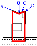
8.2.16.2 Black Arrow Method
Where a deed states the line of a boundary is the centre line of a physical object which is shown on the OS Map, a black arrow will be drawn across the object on the Title Plan.
Where a deed states the line of boundary is the face (inner or outer) of a physical object which is shown on the OS Map a black arrow will be shown pointing to the stated face.
A black arrow must be added to each feature between feature intersections or where the feature changes direction.
| Example |  |
This method is considerably quicker than using the Blue Arrow and lettering method for the following reasons: -
(a) Detailed descriptions of boundary designations are not required.
(b) Boundary Stamp on the Title Plan is not required.
(c) General Information Note 2 on the Land Certificate cover adequately describes the use of such arrows, therefore no further information is required.
Plans Staff are therefore encouraged to use this method where possible, however it may only be used where the result will be clear and unambiguous. It is recommended for standardisation that the length of the arrows be approx. 10m when depicting centre lines and 6m when depicting inner or outer faces.
The Black Arrow method is not suitable in the following circumstances.
(a) If there are numerous intersections on the boundary, since each feature at every intersection would require referencing. This may of course still be preferable if the plot is of sufficient size.
Example
The north boundary of the property requires to have black arrows position as shown on diagram . This causes a lot of clutter and untidiness to the Title Plan therefore the better option in this instance would be to use letter and arrow method

(b) If outbuildings are shown on the OS Map which are not referred to in the deed
(c) If the plot is bounded by small boundaries with numerous changes in direction.
Example
The north boundary of the property requires to have black arrows position as shown on diagram . This causes a lot of clutter and untidiness to the Title Plan therefore the better option in this instance would be to use letter and arrow method

8.2.16.3 Boundary References – Using Blue Arrow and letter Referencing Method
The boundaries are referenced using blue arrows and letters. The arrows must point to the extremities of the boundary referred to. When adding letter references, plans staff should refrain from using the letters ‘I’ and ‘O’ (to avoid any ambiguity with the numbers one and zero).
The following Boundaries Stamp is put on the front of every Title Plan which uses this method.
"The boundaries indicated hereon are more fully defined in the Title Sheet"
Extract of the O.S. map | Description contained in Deed | Explanation | Title Sheet Entry |
1.
|
“.....centre line of a mutual fence and range thereof..... |
The range is the projection to the centre of the road. The defined boundary is referenced up to the edge of the road |
A-B -East Boundary - centre line |
2.
|
“......centre line of a mutual fence and range thereof...... |
Range is from the end of the firm feature to the centre of road. |
A-B -East Boundary - centre line |
3.
|
“......centre line of a mutual fence and range thereof...... | New feature, the boundary is fully plotted, no feature depicted on the O.S. map. Therefore a reference is given for the whole boundary up to the road. When the O.S. map is updated to reflect the feature the boundary reference will be amended. |
A-B -East Boundary - centre line |
4.
|
“...........On or towards the north north east, north by west and north along which it extends (First) on the north north east thirty feet or thereby along the centre line of a hedge (Second) on the north by west twenty five feet or thereby along the inner face of a stone wall and (Third) on the north fifteen feet along the outer face of a garage wall....” |
In this case the deed refers to each boundary separately, therefore each must be given a separate reference if the boundary is in different positions i.e. centre line, inner and outer face. | A-B - North north east Boundary - centre line B-C-North By West Boundary inner face C-D - North Boundary - outer face |
5.
|
“...........On or towards the north north east, north by west and north along which it extends (First) on the north north east thirty feet or thereby along the centre line of a hedge (Second) on the north by west twenty five feet or thereby along the centre line of a stone wall and (Third) on the north fifteen feet along the centre line of a wall....” |
Although the boundaries are all described separately they are all centre lines therefore one boundary reference will suffice |
A-B -North Boundary - centre line |


For fully plotted boundaries where it is possible that a fence will be erected at a later date, the plotted boundary stamp must also be used on the Title Plan.
The boundaries shown by dotted lines have
been plotted from the deeds. Physical
boundaries will be indicated after their
delineation on the Ordnance Map
Note This stamp is also used if a boundary is fully plotted but has no specific boundary reference
Update the A. Property Section on the LRS under boundary notes. See Section 17 for instructions.
8.2.16.4 Boundary References - Juts
Juts or steps that comprise a change of boundary designation that are not capable of being reflected on the Title Plan will be referenced with a single letter. This letter will be referred to as necessary with regard to other boundary designations on either side, but information regarding the 'unplottable' boundary will be reflected verbally, e.g. "D southern boundary 0.18m". Any other boundaries on either side would be referred to in the usual way, e.g. "C - D......" and "D - E....." with no measurement quoted.
For the avoidance of doubt, a step or jut in a boundary that is designated in the same way as the boundaries either side does not require separate referencing. A boundary that contains one or more steps but where all are designated the same, need only be referenced by one letter at each end of its depiction on the map.
As the LRS Title Boundary Note screen was not designed for instances such as this, the information has to be added along these lines:
Under 'A-B' insert the single boundary letter.
Under 'Boundary' insert the compass designation in full plus the actual designation (e.g. centre line).
Under 'Line' insert the measurement , e.g. 0.2m or thereby. (Should the measurement be given to two decimal places, it will be necessary to include part or all the measurement under 'Boundary', otherwise the word "thereby" will be truncated.)
e.g. A-B North Boundary Centre Line
B East Boundary Outer Face 0.04m or thereby
B-C North Boundary Centre Line

Please note that some compass designations may need to be abbreviated for example 'west-south-west boundary' as 'WSW boundary' or 'west-south-west bdy'.
8.2.16.5 Boundary References - Table Or Legend On Deed Plan
Sometimes (especially in Local Authority casework) the deed plan will include a table or legend similar to the following
Description
| Line | Feature | Length m |
| A - B | CL OF JERVISTON ROAD | 8.0 |
| B - C | CL OF MEAN WALL & RANGES | 30.9 |
| C - D | SIDE OF PATH | 8.1 |
| D - A | CL OF MEAN WALL & RANGES | 31.0 |
The table will be referred to in the narrative of the deed as follows or in a similar manner
"All and Whole that plot or area of ground lying ..... the boundaries of which are more particularly specified in the Table and supplementary sketch endorsed on the after mentioned plan all as the said plot ......... is shown edged red on the plan annexed ....... hereto."
Then the boundaries must be reproduced on the Title Plan following the most appropriate method (Black Arrows or Blue Arrows and letters as described previously).
If the legend does not narrate the compass orientation of the boundary then the appropriate field must be left blank on the LRS.
If the legend or table is not referred to in the narrative of the deed then the boundaries must not be reproduced on the Title Plan.
8.2.17 External Boundary Juts
When asking the question -" When does a Plan settler show a jut on a Title Plan that is shown on a deed plan?" - the following must be taken into consideration
The Ordnance Survey publish no rules for when a jut in an external boundary should be depicted on the map however the following guide lines can usually be relied upon: -
- If a jut is larger than 1m at 1/1250, 2m at 1/2500 or 5m at 1/10,000 then there is no question that the jut should be shown on the Ordnance map.
- Where the jut is less than 0.2m at 1/1250, 0.4m at 1/2500 or 1.8m at 1/10,000 the jut will not be depicted on the Ordnance Survey map.
- If the jut measures somewhere between the two measurements above then it is up to the discretion of the O.S. surveyor as to whether the jut is depicted on the map.
When preparing the Title Plan for you application please takes into consideration any decisions that have been taken on adjoining registrations. However in general: -
- if the feature is depicted on the Ordnance Survey map and the jut is not shown as part of the feature as it is outwith the OS criteria for the base scale then the Title Plan should be mapped following the Ordnance Survey feature. If the jut requires a separate boundary reference - See Section 8.2.16.4 - Boundary References - Juts
- if the feature is depicted on the Ordnance survey map and the jut is not shown as part of the feature but within the OS criteria for the base scale then the Title Plan should be mapped plotting the jut and the plotted boundary stamp added if appropriate.
If it can be ascertained from the deed plan or previous registrations in the area that there are various discrepancies in the surrounding area then consideration should be given to contacting Mapbase Maintenance in order that they can liaise with the Ordnance Survey on the quality of the map. - if there is no feature depicted on the Ordnance Map and the jut is equal to or larger than 0.2m at 1/1250, 0.4m at 1/2500 or 1.8m at 1/10,000 then the Title Plan should be mapped plotting the jut and the plotted boundary stamp added if appropriate.
- if there is no feature depicted on the Ordnance Map and the jut is less than 0.2m at 1/1250, 0.4m at 1/2500 or 1.8m at 1/10,000 then the Title Plan should be mapped by plotting the feature without showing the jut.
It may be from time to time that an agent will return a Land Certificate for a jut to be shown even although it is explained to him that the jut is not shown because of the scale of the map. In these instances, if the agent still insists on the jut being shown the Keeper will comply with the addition of an enlarged plan
Consultation took place with the Ordnance Survey in 1990, and they agreed that boundary juts will in future be shown by their surveyors when the jut in question exceeds 0.4m at 1/1250 scale, or 0.8m at 1/2500 but only as part of a survey which the Agency has requisitioned and only if specifically requested on the survey form.
8.2.18 Internal Boundary Juts
The policy with regard to boundary juts is clearly explained above. However applications containing deed plans which show small juts within the extent of a steading continue to pose problems and cause confusion and, in particular those deed plans which show juts in buildings, common paths etc.
The examples shown below are to be seen as guidelines to assist in creating a uniform approach to this type of case.
The examples show the plotted extent which will appear on the Title Plan. Colours have not been shown.
There are always going to be cases which can not be covered by hard and fast rules - IF STAFF ARE IN ANY DOUBT THEY MUST REFER TO THEIR TECHNICAL REFEREE.
EXAMPLE 1: Deed Plan
Title Plan

The juts in the building and paths on the Deed Plan do not fall within O.S. criteria and can be treated as insignificant. They are therefore, as illustrated, not shown on the Title Plan. However instances could arise when these areas have particular importance e.g. when acquired separately or when subject to specific burdens which are indicated on the Deed Plan, and on those occasions may have to be illustrated - IF IN DOUBT - REFER.
As noted above, if an agent insists on the jut being shown, the Keeper will comply with the request by adding an enlarged plan to the Title Plan.
EXAMPLE 2: Deed Plan
Title Plan
Although not falling within O.S. criteria, the juts in the building and paths on the Deed Plan are large enough to be quite easily plotted on the Ordnance Map. They should, therefore, as illustrated, be plotted on the Title Plan.
In general Plans staff should note that Supplementary Plans (using a Copy of the Deed Plan) must not be used as an easy option for depicting extent. Our first remit is to identify subjects on the Ordnance Map. Again IF IN DOUBT - REFER.
8.2.19 This section is currently unused
Intentionally Blank
8.2.20 Cumbernauld Development Corporation
The instances of diverse conveyancing style of Corporation property in Cumbernauld required special consideration to establish a comprehensive way of providing sufficient instructions to enable as many applications as possible to be mapped, without further reference. It also provides uniformity in mapping and property description styles.
Additional, more comprehensive back-up information is stored in the Plans Section in Research Area number order relating to the R.A. number. This information consists of survey reports which list details such as occupation of rooms over pends, existence of garages under houses etc. This type of information will be particularly useful when considering problem casework. Staff should make full use of it before ordering surveys etc.
If a problem requires the attention of a Legal settler, the case must be referred to Legal Staff marked "CUMBERNAULD CASE" before being mapped. The problem should be clearly identified and noted in writing.
8.2.21 SSHA and Scottish Homes
Deeds of Conditions covering SSHA/Scottish Homes properties are fairly uniform in composition. In order to assist the Legal Settler to edit the deed, two standard plans references have been agreed. If there is a garage forecourt requiring to be referenced on the Title Plan, it must be tinted MAUVE. If there are clothes poles requiring to be referenced on the Title Plan, they must be indicated by the letters 'CP' and arrowed in blue to the precise point.
By way of information, there is given here the two notes that will follow the Deed of Conditions entry on the Title Sheet.
NOTE 1: If there is included in this Title a right in a garage forecourt as specified in the above Deed of Conditions, the garage forecourt will be tinted mauve on the Title Plan.
NOTE 2: If there are, in relation to the subjects in this Title, any clothes poles as specified in the above Deed of Conditions, each clothes pole will be indicated by the letters CP and an arrow on the Title Plan".
Knowledge of the existence and use of these notes edited in by the Legal Settler should demonstrate the importance of adhering to the Standard references. By way of further emphasis it must be stressed that on no account must mauve tint be used for referencing anything other than a garage forecourt on SSHA/Scottish Homes titles.
The clothes poles references (CP) must be indicated on the Title Plan, not a supplementary plan, as the Legal Note 2 clearly refers to the Title Plan. Consult your technical referee should difficulties arise.
8.2.22 Enlargements and Enlarged Plans
The comparatively small scale of the normal Title Plan sometimes means that clarification of certain detail is required. This may be done in one of the following ways: -
(i) If only a small part of the plan needs clarifying an 'enlargement' or an 'enlarged plan' may be added and inset on the face of the Title Plan.
or
(ii) a supplementary plan may be used. (see next section)
(a) 'Enlargement' should be used when a scale enlargement of part of the detail shown on the Title Plan is added. Enlargements shown on official plans should show either a bar scale or the scale as a representative fraction (i.e. 1:500 - to prepare Enlargements or Enlarged Plans to a specified scale see Section 13.6.9). The Ordnance Map should be visible on the Enlargement.
(b) 'Enlarged Plan' should be used when the addition is an extract from a larger scale plan, e.g. an architect's or a surveyor's plan or a deed plan where the scale is reliable. Enlarged Plans should show either a bar scale or the scale as a representative fraction. The Ordnance Map should not be made visible on the Enlarged Plan since the Enlarged Plan is not based on the Ordnance Map
When one of these inset plans is added to a Title Plan, a note drawing attention to it must be made as near to the point of its application as possible e.g. 'SEE ENLARGEMENT', or 'SEE ENLARGED PLAN' (or whichever is applicable). Where a number of inset plans appear on a Title Plan they should be individually numbered e.g. 'SEE ENLARGEMENT 1' etc.
For the avoidance of doubt Enlarged Sketches may no longer be used.
See also Section 13.6.9
8.2.23 Supplementary Plans
A Supplementary Plan to a Title Plan may be added at the discretion of a senior officer to overcome any deficiency of the Title Plan in scale or size. For example it may be introduced to show an 'enlargement' of a part too big to inset on the face of the Title Plan itself, to provide a means of reference to areas too small to be clearly shown on the Title Plan, or to areas which may be outside the registered land which cannot be shown satisfactorily on the Title Plan (e.g. an appurtenant right of way over a bridle road), to show removals of parts of references for Feus at different floor levels etc.
A Supplementary Plan may be made for use with a new Title Plan to show the extent of the land included at different floor levels. It may also be employed as an adjunct to the granter's Title Plan to distinguish the extents of offices separately transferred or feued, for the purpose of reference in the D. Burdens Section.
8.2.24 Confirmation of Boundaries
If an applicant wishes confirmation that the titles of adjoining subjects agree with his titles regarding the part of the physical object which forms the mutual boundary, even although the adjoining subjects are not yet registered, the Keeper may provide such confirmation on the payment of a fee. The fee will cover the expenses of his studying relevant Sasine Register volumes or copies therefrom. If confirming, the Keeper will add one of the following notes (whichever is appropriate) after the boundaries note on the Title Sheet: -
NOTE: The aforementioned boundaries have been confirmed by the Keeper.
NOTE: The boundaries marked ............... on the Title Plan have been confirmed by the Keeper.
It should be noted that the confirmation will do no more than confirm that the titles of the adjoining properties agree as to the part of the physical object which forms the boundary. There is no guarantee by the Keeper that the existing physical object depicted on the Ordnance Map is the object referred to in the titles. For instance the titles of the adjoining subjects may agree that the mutual boundary is the centre line of a hedge, whereas the black line on the Ordnance Map indicates a wall which may have been built wholly on the land of the adjoining proprietor. The wall may have been erected immediately adjacent to the hedge, which has since withered or been removed.
8.2.25 Referrals from Legal
Where cases are returned to Plans for further mapping work to be carried out it is essential that any requisitions raised by or on behalf of the Legal Settler are explained. If the mapping work is straightforward this should be completed, notes added as required and the case sent on its way. However if the requisitions are complex and difficult to comply with the case should be referred to a senior member of the Plans Staff. In some instances it may be necessary to discuss the matter with the Legal Settler to see if an alternative means of reference can be found.
All cases travelling from Legal to Plans must be routed via the appropriate senior officer. These must be treated expeditiously and the Legal Settler informed if a delay is likely.
8.2.26 Correction Cases (CX)
A CX or correction case in created either when:
- A solicitor returns the Land Certificate and requests an amendment to the Title Plan and/or the Title Sheet, where he feels an error has been made in the registration process (not to be confused with Rectification required due to an error in conveyancing), or
- Whilst processing a correct application, an earlier registration is found to be in error, and the solicitor is informed and who subsequently submits the Land Certificate for amendment.
Obviously only those CX cases where Plans related input is required is passed to Plans section. The cases are received by the appropriate senior officer for noting, and are then passed, wherever possible, to the Officer who settled the case, or if appropriate, the officer who gave the mapping instructions.
Whenever any doubt exists as to the action to be taken, a senior officer should be consulted, and any points of a legal nature must be referred to Legal staff.
It must be borne in mind that CX cases are, in fact, a rectification of the register, and any proposal for amendment must not prejudice any proprietor (whether of the subjects in question or of adjoining land) in possession. Section 9 of the Land Registration (Scotland) Act refers.
8.2.27 Certificate Plans (Defacement Of)
Despite the warning printed on the front of the Land Certificate, from time to time it may be found that the Certificate Plan within has been spoilt by unauthorised markings whilst outside the office.
If any such marking is considered to be indelible and a new Plan is required, the Land Certificate should be sent to Legal staff with a note of Plans staff's observations which should include an estimate of the cost of replacement; i.e. the full cost of materials and labour. Legal staff will take whatever action may be necessary and return the Land Certificate to Plans staff with their requirements.
8.2.28 Record Maps (Defacement Of)
Attention is drawn to the defacement of Record Maps (e.g. by the addition of pencilled information to indicate the limitation of areas to be photographed). Any such pencil additions must always be erased when their purpose has been served.
8.2.29 Natural water boundaries
See the Legal Manual, Section 18 Foreshore, Seabed and Natural Water Boundaries
Under section 6(1)(a) of the Land Registration (Scotland) Act 1979, as amplified by Rule 4 of the Land Registration (Scotland) Rules 1980, the property section of a title sheet must contain a description of the land based on the ordnance map. Unless section 12(3)(d) of the Act is applicable (where there is an inaccuracy in the boundaries which could not have been rectified by reference to the OS map) or there is an express exclusion of indemnity to the contrary, the Keeper guarantees the boundaries of registered subjects. Subjects which have as one of their boundaries a natural water feature, such as a river, loch or the sea, present additional considerations for the Keeper both at the time of first registration and subsequently. These issues are discussed in the following paragraphs.
It is stressed that the term 'natural water boundary' in this discussion means a boundary with a feature that has evolved through nature such as a river, loch or the sea, rather than with a man-made water feature such as an artificial loch within a housing or leisure development. The term also includes the landward and seaward boundaries of the foreshore.
8.2.29.1 Registration problems
The mapping of natural water boundaries poses two main problems for the Keeper. Firstly, there may be difficulties in interpreting what the description in the prior recorded titles means (e.g. a reference to subjects as being 'bounded by' a river may mean that the boundary is the medium filum if the river is non-tidal at that point, but will normally mean the river bank if the river is tidal). Secondly, natural water boundaries are prone to fluctuate according to the seasons and weather conditions, and may permanently change as a result of alluvio (gradual alteration due to natural causes), avulsio (sudden, violent detachment of land) or deliberate reclamation. The assumption in property law is that the title boundary will move with the water feature in some cases (e.g. alluvio) but not others. Movement may have occurred between the granting of the split-off deed and the time of first registration, or it may occur after registration has taken place. The Keeper is bound to reflect the true title position at the time of first registration, and where necessary to update the register to take account of movement subsequent to registration. However, he does not have the jurisdiction to decide in an individual case whether the movement of the physical feature has resulted in a change to legal title. Moreover, the Keeper has to balance the need for reliable, definitive mapping against the potential requirement to rectify a title boundary which has moved due to alluvio.
8.2.29.2 Policy
The Keeper's present policy on natural water boundaries applies in all FR and TP applications received after 20 May 2002 where the subjects are bounded by or include part or all of a natural water feature. The policy has two strands:
- Titles adjacent to or including part or all of a natural water feature (including foreshore) should be mapped so that the red edge or tint includes the fullest extent of that feature consistent with the titles
This is designed to ensure that a search of the DMS (whether by ROS staff or through Registers Direct) will always reveal a registered title which may include the area searched. - Indemnity should be excluded in respect of any alteration of the boundary caused by alluvio
This is designed to allow the Keeper to take advantage of the rectification provisions in the Land Registration (Scotland) Act 1979 where alteration of a natural water boundary leads to a change in the legal title extent, either before or after first registration.
- Titles adjacent to or including part or all of a natural water feature (including foreshore) should be mapped so that the red edge or tint includes the fullest extent of that feature consistent with the titles
The paragraphs below give some general guidance for registration officers on the way that this policy should be applied. However, since the instructions cannot cater for all eventualities, any case which does not appear to be straightforward should be referred to the officer's team leader or a Plans RO1, who will if necessary refer it to a senior caseworker in Registration Services for guidance. Even in straightforward cases, normal casework grading rules apply (e.g. cases where the subjects include foreshore should be categorised as X3).
8.2.29.3 Mapping guidelines
In individual cases, plans registration officers should take into account both the written description and the plan (if any) in the relevant split-off deed(s). Where there is a deed plan, they should check whether the course of the water feature as shown on that plan differs significantly from that shown on the DMS. Any conflict between the written description and the plan should be referred to a team leader (who will if necessary consult with a senior caseworker), as should any case where there is a significant difference between the course of the water feature revealed in the titles and what is shown on the DMS. Plans staff should also bear in mind the established methods of interpreting verbal bounding descriptions referred to in Section 12.2.3 of the Plans Manual, but in the event of a conflict between these presumptions and the titles, it is the titles which will normally prevail. Again, a plans officer who is in any doubt should refer to a team leader or senior caseworker.
Subject to the above, the plans registration officer should proceed as follows:
1. The subjects should be mapped to the fullest extent consistent with the titles, e.g.
- where the boundary is a non-tidal river, mapping should be to the medium filum unless the titles suggest otherwise;
- where the boundary is a tidal river, mapping should be to the river bank unless the titles suggest otherwise;
- where the boundary is the foreshore, mapping should be to the mean high water mark of ordinary spring tides, unless the titles suggest otherwise;
- where the subjects include the foreshore, mapping should be to the mean low water mark of ordinary spring tides, unless the titles suggest otherwise.
2. The water boundary should be letter-referenced.
3. A note should be added in the Property Section detailing the specific terms of the Natural Water Boundary and should be entered using the "A Section Notes" function This note should specify the terms of the boundary as expressly stated in the Titles and not what is implied by virtue of the presumptions in Section 12.2.3 of the Plans Manual e.g. The boundary between the points marked A-B on the Title Plan is the medium filum/bank/south bank of the river XXXX
Plans officers should utilise the existing exclusion of indemnity notes available from the drop down menu for the "A Section Notes", legal will take responsibility for and, if necessary, edit the terms of the exclusion note if required (EX4 note should be utilised when foreshore is included and EX3 note for all other Natural Water Boundaries).
4. The legal settler should be informed that an exclusion of indemnity is required in relation to the natural water boundary shown on the title plan.
8.2.29.3a The foreshore in Orkney and Shetland
Because of the implications of udal law, special considerations apply to the mapping of coastal titles in Orkney and Shetland. The assumption is that a udal title adjoining the coast will include the foreshore. The Crown has no prior right to the foreshore under udal law. Where coastal udal titles are recorded in Sasines, they will normally describe the foreshore verbally, rather than by reference to a deed plan.
Under udal law, the title to the foreshore extends to "the lowest ebb". This may fall at a lower point than the mean low water mark of ordinary spring tides (MLWS). The Keeper does not consider that it would be realistic for him to attempt to identify the precise extent of the "lowest ebb" in individual cases. Accordingly, titles in Orkney and Shetland that are stated to include the foreshore should be red-edged to the MLWS as shown on the current OS. However, the implications of udal law should be reflected by way of a note in the Property Section of the title sheet in the following style:
NOTE: The subjects in this title include foreshore. While the title plan shows the extent of the foreshore as being bounded by the mean low water mark of ordinary spring tides, the subjects extend to the lowest ebb.
This note is in addition to the exclusion of indemnity referred to in paragraph 8.2.29.4.
Applicants may have concerns with regard to areas which lie below the MLWS but which have been possessed (e.g. by the construction of a pier) on the assumption that they are included in the udal title 'to the lowest ebb'. Registration officers should not entertain requests to map a registered title in such a way that it explicitly includes an area further seaward than the MLWS, since to do so might open up the potential for conflict with the Crown's assumed prior right to the seabed.
The instructions in this paragraph apply to all titles in Orkney or Shetland which are stated to include foreshore and which do not derive from a Crown grant.
8.2.29.4 Exclusion of indemnity
The legal registration officer will take responsibility for the exclusion of indemnity in the Property Section of the title sheet. The Legal Manual gives instructions to legal staff as to the wording of the exclusion note. Such exclusions of indemnity will be permanent, as the possibility of alteration of the boundary is not a matter which can be 'cured' by prescription.
8.2.29.5 Existing registered title
On registering a title according to the above guidelines, a conflict may arise where the subjects of the application adjoin or overlap an existing registered title mapped according to the policy in operation prior to 20 May 2002. Any such conflict should be referred by the relevant team leader to a senior caseworker, who will if necessary seek the advice of Senior Legal Group.
8.2.29.6 Rectification
Any question, subsequent to registration, as to whether the natural water boundary is correctly shown - or any suggestion that the title boundary has altered as a result of alluvio - will be treated as a matter of rectification. All such questions or applications should be referred to Senior Legal Group in the first instance.
8.2.29.7 Applications prior to 20 May 2002
The following instructions apply where staff are processing an application for FR or TP which was presented to the Keeper on or before 20 May 2002. These instructions arise from an agreement between the Keeper and the Law Society which is reflected in paragraphs 6.99 et seq. of the Registration of Title Practice Book.
1. If it is clear from the deeds and the Ordnance Map where the natural water boundary lies and the exact line of that boundary and that boundary in turn can be plotted with absolute accuracy on the Title Plan, then the boundary should simply be red edged on the Title Plan in the same way as any other boundary would be. Given the above comments it is envisaged that this option will only apply in a limited number of instances.
2. Delineate the natural water boundary by means of a red edge on the Title Plan and add a qualifying note to the Property Section. The qualifying note will be to the effect that the natural water boundary shown on the Title Plan is only indicative of the actual position of the boundary feature, i.e.:
NOTE: The northern boundary comprises the medium filum of the River X.
3. Delineate the red edge on the land abutting the natural water boundary and add a note to the Property Section indicating that a natural water feature or part thereof is included within the title. For example:
NOTE: The foreshore ex adverso the northern boundary between the points arrowed and letter referenced A and B on the Title Plan is included within the title.
4. In situations where none of the foregoing methods is appropriate the Keeper will exclude his indemnity as regards the position of the natural water boundary.
No hard and fast rules can be given as to which option will be appropriate in all situations. Plans staff should adopt whichever method appears practical in any given set of circumstances. That said, as option 1 presents the most risk to the Keeper's indemnity it should be adopted in only the most clear cut of cases. Reference should be made to a senior plans officer before adopting options 3 or 4. The following factors should be taken into consideration in deciding which option is appropriate:
1. Length and shape of the natural water boundary - The longer and more irregularly shaped the boundary the more difficult and time consuming it will be to plot accurately on the Title Plan. Plans staff should consider where possible attempting to map as described in Options 1 and 2 above, however it is recognised that this may not be practical in certain instances. In such circumstances advice should be sought from a more senior plans officer.
2. The title deeds - The way the subjects are described in the title deeds and depicted on any plans relative thereto will clearly influence which option is appropriate. Similarly, the older the foundation title the more risk there will be that the natural water feature will have altered over time. In some deeds the subjects will be described by reference to the land but then include the water feature in the parts and pertinents clause, i.e. 'together with the foreshore etc.'. If that feature has not been shown on a deed plan no attempt should be made to subsequently show it on the Title Plan, rather the procedure detailed in option 4 should be followed.
3. Identification and plotting on the Ordnance Map - In areas of mountain and moorland, where the scale of the Ordnance Map is 1:10000, some small deviations in the course of a burn or even a narrow river may be rationalised into a simpler representation. Also, closely aligned features that would be shown on larger scale maps as separate features will be shown by a single line: the line will be assumed to reflect the more substantial of the two features. In such circumstances a simple red edge on the Title Plan would not suffice in itself to clarify exactly where the boundary lies as the red edge itself may be wider than the natural water feature.
4. Alterations in the course of the natural water feature - This will not always be apparent from the information available to the Keeper, but where the settler is aware of past movement in the natural water feature caution should be exercised. If the cause of the movement is avulsion the basic legal premise is that the original legal boundary is deemed not to have moved. Where alluvio occurs the legal boundary is taken to move in accordance therewith. Thus, for example, if subjects are bounded on the north by the medium filum of a river and that river alters course through time because of alluvio the boundary of the subjects will also move. If alluvio causes the river to move northwards the extent of the subjects will consequently be increased. The problem for the Keeper is that he is not in a position to know whether movements in a natural water feature are due to alluvio or avulsion or some other cause such as reclamation. If such movements result in a reduction in the extent of the subjects being registered and the submitting agent is content to accept this no problems will arise for the Keeper. In any other situation the Keeper will require to be satisfied that no risk to his indemnity exists before considering any option other than 4. The matter therefore becomes one of evidence. Satisfactory evidence may include an agreement from all affected proprietors as to the current boundary or a court decree affirming the cause of the movement and determining the current boundary position.
5. Nature of the natural water feature - In particular, whether the natural water feature is one which is prone to change. Some rivers, particularly those which are tidal, and indeed certain stretches of particular rivers, are noted for wide fluctuations in their natural course. The River Tay is a prime example. A cautious approach should be taken when processing applications relating to such rivers. By contrast, lochs being in general non-tidal are less prone to fluctuations.
8.2.30 Registrations affected by prior Feus or Leases.
An application for First Registration maybe made in respect of subjects out of which feus or leases have been granted prior to the application - either in Sasines or in the Land Register. Since in these cases the applicant retains an interest in the whole subjects, burdened by the interest of the feuar or lessee, the application must be treated in a different way from the one in which parts have been conveyed away by Disposition and the applicant no longer holds an interest in land.
Where Feus or Leases have been granted prior to First Registration, the whole of the original subjects are included within the red edge and the restriction of the interest in the parts feued or leased to that of superior or landlord is indicated by edging and numbering those parts with a different colour, - blue in the case of feus and yellow in the case of leases. The Plans Settler will inform the Legal Settler what references have been provided, in order that the Legal Settler can prepare a schedule of Feus or Leases for the Property Section.
Please note that if the Feu or lease is co-extensive with the extent of the subjects in the Title then no separate reference will be required.
8.2.31 Salmon Fishings
Please see Legal Manual Section 45 Salmon Fishings for a background to this topic.
8.2.31.1 Plans Settlers and Salmon Fishings
First Registrations of fishing interests involve specialities and complexities, which are not found with other interests in land. Due to this fact these applications are categorised as X3 and therefore must be completed by Plans RO1 or Plans RO2 under the guidance of Plans RO1. The rest of this section deals with the areas that affect the plans settler and are not covered in either the Legal Manual or Indexing Guidelines.
The method used to map the subjects is very much dependant on the way the deed has conveyed the subjects. Where possible the normal mapping methods should be utilised. The following sections provide information on how to proceed where this is not possible.
8.2.31.2 Sea Fishings
The deed will more often than not describe the subjects being transferred as the salmon fishings in the sea between the points A and B on the deed plan.
Obviously this description does not meet the normal expectations in that the subjects are not fully defined however the verbal description along with the points A and B on the deed plan fully meets the criteria laid down for a verbal description.
To try to define the precise extent being transferred within the application is impossible for various reasons namely
(a) Prior to 1987 the limit of the United Kingdom's territorial waters was 3 international nautical miles. In 1987 it was changed to 12 international nautical miles the law is unclear as to whether salmon fishings extend to this limit as there as been no case law to challenge it.
(b) The Ordnance Survey Maps do not extend this far.
Therefore the Plans Settler will have to map the Title Plan in the same manner and reproduce the letters A B and describe the subjects verbally in the terms of the deed.
8.2.31.2.1 Indexing
Obviously as there is no polygon searching between these two points, an index map search would not disclose the title and even if it was listed when the common areas functionality would not reveal the title.
Therefore the mapper must create a white polygon over the area that is in the Title and over which they would expect another mapper to search against.
A Back up file (BUF) should also be created (see Section 14.1.8.2. - BUF - BACK UP FILE) to alert other users to the Title.
8.2.31.3 Strips of ground
Where the salmon fishings form part of a river the subjects often include the dominium utile to a strip of ground along the riverbank; more often than not this area is verbally described.
Caution has to be exercised in defining this strip on the Title Plan. As we are dealing with a natural water boundary there is a high possibility that the position of the bank may have moved since the deed was drawn up, and by simply plotting this boundary without further investigation may create a competing title with the adjoining property.
Where possible the extent deeds should be obtained for the adjoining subjects to ascertain the extent of this property. If the mutual boundary is depicted on the deed plan and its position is not described in relationship to the river, thereby not a natural water boundary this can then be used to define the extent of the strip of ground.
Where the extent cannot be ascertained from the deed for the adjoining subjects, nor does it define the mutual boundary, consideration has to be given as to whether the area of ground should be described verbally. This should not be undertaken lightly and should also be agreed with the Senior Caseworker.
8.2.31.3.1 Indexing
When the strip of ground has been included in the Title verbally the same guidelines as laid down for Sea Fishings above must be followed.
8.2.32 Wind Farms
Wind Farms in the main fall into the category of "commercial leases", and as such the "copy in certificate" mapping method may be adopted. See section 8.2.31
The extent of the leased area and access routes should be referenced on the Title Plan, with the additional detail such as the location of the wind turbines and ancillary sites being visible via the copy deed plan in the Land Certificate
Where the Legal Settler deems that copy in certificate is not appropriate then consideration should be given to using a scanned copy of the deed plan as a supplementary plan to the Title Plan.
8.2.33 Copy In Certificate
What is "Copy in Certificate"?
In certain circumstances the Legal Settler will require to include a copy of the deed with the Land Certificate rather than edit the deed - this is know as "copy in certificate." This is purely a procedure for Legal Settlers as described later below.
For the avoidance of doubt the Plans Settler will map the application following normal mapping procedures. The remainder of the section is for information only however it should be noted that where the deed plan is coloured and a supplementary plan has not been used the Plans Settler has to ensure that they have informed the Legal Settler of all references used including exclusive rights.
Background Information
When is "Copy in Certificate" used?
Perhaps the best example of the kind of deed where "copy in certificate" could be used is the commercial lease. Most commercial leases are complex documents that impose separate obligations on both landlord and tenant.
These obligations are inter-dependant so the document must be viewed as a whole and read as a whole. Any attempt to edit the deed to show only what are perceived to be burdens affecting the tenant's interest can destroy the coherence of the deed and raises the very real danger that certain of the obligations will become unenforceable from lack of specification.
Moreover, such documents are deliberately drafted in separate clauses with headings and side notes for ease of identification and cross-reference. To produce a burdens entry in the normal way, where the clauses run into one another in an unstructured mass, makes the interpretation of an already complex deed infinitely more difficult.
There may well be other deed types where "copy in certificate" would be a preferred option. Agreements under Section 50 of the Town and Country Planning (Scotland) Act 1972 or Section 75 of the Town and Country Planning (Scotland) Act 1997 provide further examples.
The decision to adopt this method obviously lies with the Legal Settler however to ensure, that the procedure is only adopted when absolutely necessary, any Legal Settler contemplating its use must consult their Team Leader or a senior caseworker to obtain authority.
What does the Legal Settler Do?
As stated above, a copy of the deed is included as part of the Land Certificate. Therefore as such the Legal Settler must ensure that the deed is microfiched/archived so the Agency: -
• retains a complete record of the Title Sheet.
• can produce further copies of the Land Certificate when requested i.e. office copies, substituted Land Certificates etc.
Instead of editing the deed the Legal Settler will make an entry in the D section along the following lines
"Lease by A to B, registered, of the subjects in this Title, contains conditions and burdens - copy in certificate"
If the plan annexed to the deed contains colour references the Legal Settler must expand the entry as the deed plan enclosed with the Land Certificate will be a monochrome copy. This will be dependent on the mapping style chosen by the Plans Settler
• Where all the references are reproduced on the Title Plan, the Legal Settler will then prepare a table on this information for insertion in the entry in the D. Section.
• Where a scanned Supplementary Plan has been used the Legal Settler will add a note to the entry in the D. Section stating that a copy of the deed plan is included in the Land Certificate as a Supplementary Plan to the Title Plan.
Related content
*
This is the registration manual for 1979 casework.
Do not under any circumstances use the information here when settling 2012 casework. This resource has been archived and is no longer being updated. As such, it contains many broken links. Much of the information contained here is obsolete or superseded.
*
The Manual is an internal document intended for RoS staff only. The information in the Manual does not constitute legal or professional advice and RoS cannot accept any liability for actions arising from its use.
Using this website requires you to accept cookies. More information on cookies.