This is the registration manual for 1979 casework.
Do not under any circumstances use the information here when settling 2012 casework. This resource has been archived and is no longer being updated. As such, it contains many broken links. Much of the information contained here is obsolete or superseded.
P8.4 PARTS OF BUILDINGS AND STRATA LEVELS
- Former user (Deleted)
- Admin2 (Unlicensed)
Analytics
8.4.1 Introduction
The term "land" in its legal context includes among other things any ground with any buildings upon it, the airspace above it and all mines and minerals beneath it. It can also include parts of buildings whether the division is horizontal, vertical or made in any other way.
For the purpose of ownership land may be divided horizontally, vertically or otherwise and either above or below ground. Thus separate ownership may exist in strata of minerals, in the space occupied by a tunnel (or even a pipe) or in different storeys of a building.
Registrations which include only certain floor levels or strata should be treated carefully, bearing in mind that the Ordnance Map shows detail at ground surface level or, where appropriate, at the upper level of public communication.
In the case of "developments" (i.e. shopping precincts etc.) or split villas the method for dealing with registrations will be decided by a senior plans officer and written instructions will be given. Subsequent applications will follow the same style as regards shopping developments assuming no deviations from the Prior Registration exist. Further registrations from a split villa have to be looked at carefully, particularly if the prior or current registration are described as the whole 'plot' under exception.
Applications, which involve registration of parts of buildings at one or more level where there is no consistent pattern of extent, conversion of buildings, complex split level properties and sub soil strata will be referred to a senior officer as appropriate for instructions before mapping.
Always ensure that you have read the deed carefully to establish exactly what requires to be referenced. i.e. common stairwells are sometimes coloured on the plan annexed to the deed however the colour reference is not always specifically narrated in the deed and therefore no reference is required on the Title Plan.
Where a deed refers to a plan reference and this reference is shown on the deed plan, a reference will be required on the Title Plan. The reference cannot be ignored or referred to legal for a verbal reference. The only exceptions to this rule are when subjects cannot be identified on the Ordnance Map i.e. floating shape, extent not fully defined, or on specific instruction of a Team Leader/Plans RO1.
Before proceeding with the mapping of the subjects, all previous registrations must be investigated to ascertain previous mapping styles and extents. Remember that inset plans may have been used to the show detail on floor levels.
The use of create Duplicate Title should be encouraged for subsequent applications from the tenement property. This option allows the mapper to reproduce floor level plans or enlargements already prepared.
Any reference that creates competition with previously registered titles must be referred to a Team Leader/Plans RO1.
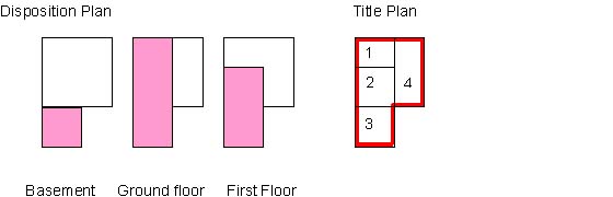
8.4.2 Simple Floor Level
A "Simple" floor level case can be defined as a purpose-built unit, i.e. a dwellinghouse being part of a building where the deed or deeds clearly define its position, extent and floor level. Converted buildings (split villas) raise different points and are described later.
Even though the titles may include several identifiable rights requiring careful consideration (for the first application out of the building) the case is classified as "simple" regarding the floor level element, because the building is purpose built and the internal divisions are clearly identifiable and easily plotted on the Ordnance Map. Consideration does not necessarily have to be given to the adjoining units, as it is a safe assumption that the deeds for all the units in such a building are compatible.
Any applications that attempt to define a unit but unfortunately include a deed plan that is only an extract plan from the surveyor's or builder's plan may not be acceptable. If the detail on the plan cannot be positively related to the Ordnance Map, the solicitor must be approached in order that the location of the unit is established, preferably by the lodging of the relevant plan for the whole floor level. Under such circumstances, a Supplementary Plan should not be used.
It is worth considering the orientation of any floor level plans: where the plan only shows one floor level, particularly the upper floors, and no surrounding features to the main building are shown, a misrepresentation of the compass point of 180 degrees may not be apparent if the shape of the building is of a simple design, e.g. a rectangle. It could be possible to plot a unit on the diagonal opposite side of a building without realising it.
 |  | |
| Deed Plan | Title Plan |
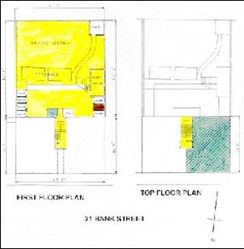
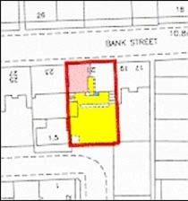
A. Property Section: -"Subjects within the land edged red on the Title Plan being the westmost flat tinted pink on the said plan on the top floor of the Tenement 21 BANK STREET ABERDEEN AB11 7TA with the coal cellar tinted brown on the said plan."
In some instances some of the references are not clear at the 1.1250 scale therefore an enlargement may be require to clarify these areas
|
| |
deed plan | title plan |
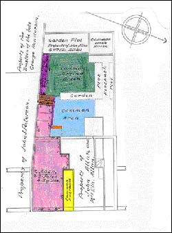
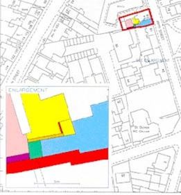
A. Property Section: -"Subjects within the land edged red on the Title Plan being 16B BOYD STREET, PRESTWICK KA9 1JZ comprising the southmost house tinted blue on the said plan of the Tenement 14, 16A and 16B BOYD STREET, with the garden ground, cellar and area of ground tinted mauve, green and brown respectively on the said plan."
8.4.3 Complex Floor Level
A "complex" floor level case can be defined as either: -
(a) An application to register property that comprises a unit in, for example, a shopping centre complex where (i) although the unit may only comprise a portion of one floor level, the development is of such a complexity that careful consideration has to be given to establishing the true situation on the site or (ii) the unit comprises occupation on two or more floors whether the extents are co-extensive or not.
or
(b) An application to register property that forms part of a building originally built as one unit but has since been altered to form two or more separate entities. More commonly this occurs with large residential property and is referred to as a "split villa" which because of special considerations is dealt with separately elsewhere (other than large "mansion" properties converted into numerous flats under large scale extensive alterations which may be properly treated as "purpose built" under this section).
Registrations of units in complex modern developments require careful consideration [as do registration of the complex developments themselves] as it is the Agency's intention to produce Title Plans which are understood by professional draughtsman, solicitor and lay-man alike.
There are various methods available to deal with complex developments and care should be taken when deciding which method to use, as the first application registered should set the style for later registrations in the development.
When deciding on which mapping method to use consideration should always be given to legal requirements and whether or not the style used will create difficulties for the legal Settler. However, the final consideration should always be the clarity of the Title Plan. There is little point in simplifying drafting for Legal Staff if the Title Plan to which they refer is so complex as to be unintelligible or is misleading.
The methods used to deal with complex developments can be said to fall under the following headings
(a) Tinting reference method (not to be confused with "tinting method") with normal A Property Section description.
(b) Tinting or numbering reference method with A Property Section description in Schedule form.
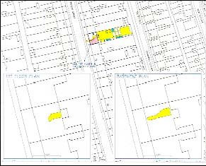
(c) Supplementary plan required to show floor levels separately whether the application is for registration of either a single unit, or the whole building or development requiring references for overriding interests.
(d) Where any of the above methods are used but the A. Property Section requires restrictive notes.
8.4.4 Floor Level - Tinting Reference Method
The subjects being registered comprise a unit occupying parts of two or more floor levels. The extents of each portion are identified and where necessary, plotted. Each affected portion is given a separate tinted reference.
There will be a right in common (or similar) with the other proprietors of the building (or possibly a portion of proprietors of the buildings or a portion of proprietors to a specific section of a large development) to the solum. If the extent of all common rights appears restricted to the building, or is restricted to a specific portion of a large complex or development, this building or area will be edged red. If this area equates or appears to equate to the solum, whether or not it is specifically colour referenced on the deed plan, any part of the building or area not covered by floor level references is not referenced. The reference to the solum will refer to the land edged red.
If, however, the extent of all common rights requires that a 'steading' be mapped, (i.e. the red edging will include land in addition to the extent of the building) a reference for that part or parts of the building not referenced for floor levels, where a right to the solum is granted, may, depending on the style of the deed, be required. In some specific instances it may be permissible to edge the building whilst giving tinted references for the floor levels.
Two examples of this style are given here:
'BUILDING' EXTENT
.jpg?version=1&modificationDate=1422533912347&cacheVersion=1&api=v2)
A. Property Description: - "Subjects 7D BEARSDEN GARDENS, MILNGAVIE within the lands edged red on the Title Plan being the dwellinghouse [or office premises or rooms etc] on the ground floor tinted pink and blue on the said Plan and on the first floor tinted pink and yellow on the said Plan of the building 7a to 7d Bearsden Gardens".
STEADING EXTENT
.jpg?version=1&modificationDate=1422533919262&cacheVersion=1&api=v2)
A property Description:- as above, but with the addition of "...tinted pink, blue, yellow and brown on the said plan".
NOTE: The brown is added to complete a reference for the whole building (as the red edged extent includes land additional to the building) so that other rights, such as rights to the solum, can be edited in by the Legal Settler.
Restrictive notes have been commonly used in early registrations, but are now considered cumbersome and unsatisfactory. The positive form of description is favoured. Some styles may, rarely, still require restrictive notes.
Notes to legal will include any references for rights (i.e. not included in A. Property Description) and a note as to how the solum is referenced.
E.g.: - "The parking area coloured orange on the plan to deed 4 to which is granted a right in common is tinted mauve on the Title Plan. The solum referred to and edged blue on the said deed plan is tinted pink, blue, yellow and brown on the Title Plan."
8.4.4.1 Floor Level - Tinting Reference Method With Schedule
The subjects being registered comprise a unit occupying parts of two or more floor levels. The extents of each portion are identified and where necessary, plotted. Each affected portion is given a separate tinted reference, or, if for technical reasons or convenience, number references may be given.
There will be a right in common (or similar) with the other proprietors of the building (or possibly a portion of proprietors of the buildings or a portion of proprietors to a specific section of a large development) to the solum. If the extent of all common rights appears restricted to the building, or is restricted to a specific portion of a large complex or development, this building or area will be edged red. If this area equates or appears to equate to the solum, whether or not it is specifically colour referenced on the deed plan, any part of the building or area not covered by floor level references is not referenced. The reference to the solum will refer to the land edged red. If, however, the extent of all common rights requires that a 'steading' be mapped, (i.e. the red edging will include land in addition to the extent of the building), a reference for that part or parts of the building not referenced for floor levels where a right to the solum is granted, may, depending on the style of the deed, be required.
An illustrative example using number reference is given thus: -
A Property Description: -
"Subjects 151 HAMILTON ROAD, MOTHERWELL within the land edged red on the Title Plan comprising the office premises on the various floors specified in the schedule below, of the building 151, 151A and 151B Hamilton Road".
NOTE: The respective extents of the several floors included in the title are shown on the said plan as follows: -
| Floor Level | Numbered on Title Plan |
| Basement | 3 |
| Ground Floor | 1,2 and 3 |
| First Floor | 2 and 3 |
If the mapping is completed "Steading" style and a reference is required for the whole building (for solum) the number 4 is added to the portion not previously referenced, and the property description is expanded; i.e. after "... Hamilton Road", add, "numbered 1 to 4 on the said plan".
Restrictive notes have been commonly used in early registrations, but are now considered cumbersome and unnecessary. The positive form of description is favoured. Some styles may still require restrictive notes: this is covered elsewhere.
Notes to Legal will include any references for rights (i.e. not included in A property Description) and a note as to how the solum is referenced.
E.g.: -"The parking space coloured orange on the plan to deed 4 to which is granted a right in common is numbered 6 on the Title plan. The solum referred to and edged blue on the said deed plan is numbered 1 to 5 inclusive on the Title Plan."
When deciding the best style for mapping, remember to take account of the Legal Settler's requirements. A style making use of floor level plans or supplementary plans may prove clearer both from a plans and Legal point of view. If it is felt from the wording of the deed, particularly where complex rights are involved, that the Legal Settler's comments may be useful, refer to Legal Staff stating any mapping proposals, requesting their confirmation that it also suits their requirements, remembering, however, that the clarity of the Title Plan is paramount.
8.4.5 Floor Level - with Inset Floor Level Plans
The subjects being registered comprise a unit or units occupying parts of two or more floor levels and confusion would be caused if all references were shown on the Title Layer.
Where possible the flat extent should be shown on the main title layer. This will ensure a successful search on the Index layer. Where possible all other exclusive rights should be shown on the Title Layer. This is particularly important when mapping is to be completed using tinting method rather that site plan method.
It may be possible to double up floor level plans especially when references are compatible on certain floor levels.
It is important, that if enlargements or floor level plans have been used that this must be reflected in the DMS case notes
Note: When inserting floor level plans they are not arrowed out on the Title Plan.
An illustrative example using number reference is given thus: -
deed plan |
title plan |
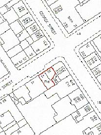
A Property Section: -"Subjects being the lefthand first floor flat tinted blue on the Title Plan at 106 UNION GROVE ABERDEEN AB10 6SA of the Tenement 106 and 108 UNION STREET within the land edged red on the said plan with the coal cellar tinted brown and the garden ground tinted blue on the said plan."
deed plan |
title plan |
A Property Section: -"Subjects within the land edged red on the Title Plan being the on the middle or first floor flat tinted pink of the Tenement 26 WATSON STREET ABERDEEN AB25 2QJ with the three areas of garden ground tinted blue on the said plan and the coal cellar on the basement floor tinted brown on the said plan"
8.4.6 Floor Level - With Supplementary Plan
The subjects being registered comprise either
(i.) A unit (or units) occupying part of two or more floor levels, and confusion will be caused if all shown on the Title layer and two floor level plans
(ii.) A whole building (or complex such as a shopping precinct) where some units have been feued or leased. It is decided that due to either the number of different levels involved and/or the irregular size and shapes of parts involved that mapping solely on a Title Plan would prove confusing or impossible, a supplementary plan to the Title Plan is prepared, using the image functionality
A Supplementary Plan to the Title Plan should either be based on the Ordnance Map [revised and enlarged if necessary] or on an architect's or surveyor's plan, or will consist of a straight colour copy of the plan. If from the description of the property in the deeds it is obvious that a complex multi-floor development is involved but no floor level plans have been lodged it may be possible to acquire these by requesting floor level plans from the seller's agents. Plans may already be in the Agency's possession where they have been acquired in connection with Form 10 reports on receipt of the first application to register a unit out of the building or development. Of course, in most instances, the deeds themselves will contain plans that will provide a basis for the Supplementary Plan. It is essential that the detail on the Supplementary Plan can be related to the detail on the Title Plan and this is generally achieved by showing on the Supplementary Plan the main outline of the building or enough of it to make identification on the Title Plan straightforward.
According to the number of floors, the different levels of the building are shown and named on the Supplementary Plan, e.g. basement, ground floor, first floor etc. in ascending order. Where the extents of the properties on a number of floors are identical all such floor levels can be indicated on the one plan on the Supplementary Plan providing that it is clearly labelled to this effect.
The extent of the building, or a steading if applicable, or that portion of a complex where all shared rights are included, is edged red on the Title Plan. Any references required for burdens affecting (from instructions given in the Research Area notes or for the specific application by the Legal Settler) and boundary references, are shown on the Title Plan. References for parking spaces, garages, common paths, drying greens, bin stores etc. are normally also shown on the Title Plan. Appropriate references for the floor levels will be applied to the supplementary plan or plans - (for the sake of clarity, a supplementary plan in several parts is an option). Where the supplementary plan or plans are colour scans of the deed plans, they will already show by colour reference (usually edging) the extents of the floor levels. Ensure they are legibly marked as to the levels involved. If any colour edging is too thin or feint to be seen clearly, the edging can be enhanced on a colour copy by the appropriate colour before scanning takes place.
title plan |
deed plan |
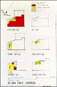
N.B the appropriate Supplementary Plan stamps should be added to both the Title Plan and the Supplementary Plan.
A. Property Section: -"Subjects being the first floor flat tinted pink on the Supplementary Plan to the Title Plan at 39 JOHN STREET ABERDEEN AB25 1LN of the Tenement 39, 41 and 43 JOHN STREET edged red of the Title Plan with the storage cupboard and the three cellars all in the basement and tinted pink on the said Supplementary Plan"
Two examples are given here: -
(a) The registration consists of office premises on the ground first and second floors of a building and all common rights exist within the solum area of that building.
The building is edged red; the three floor levels are tinted pink on the supplementary plan.
The A. Property Section Description reads: -
"Subjects within the land edged red on the Title Plan being office premises on the ground, first and second floors tinted pink on the Supplementary plan to the Title Plan of the building 90 GEORGE STREET, GLASGOW."
Legal Staff will be informed of the use of the Supplementary Plan, but any common rights will be directed at the Title Plan unless the supplementary plan should show other detail referred to in the deed.
(b) The registration consists of office premises on the ground, first and second floors of a building where the solum is identified to accommodate several rights, together with a specific parking area, and a right in common to an access road.
The steading is identified and edged red, the solum, parking area and access roadway are referenced on the Title Plan and the supplementary plans used comprise colour copies of three plans annexed to the deed for extent.
The A. property Section Description reads: -
"Subjects within the land edged red on the Title Plan being office premises on the ground, first and second floors shown edged red, blue and green respectively on the Supplementary Plans to the Title Plan, of the Building 90 GEORGE STREET, GLASGOW tinted blue, with the parking area tinted brown both on the said Title Plan."
Legal Staff will be informed of the use of the Supplementary Plan, and of all the references used on the Title Plan.
NOTE 1: Example (b) in an adapted form can still apply where the supplementary plans are monochrome plans.
NOTE 2: Examples of the older large terraced property in Glasgow (and elsewhere), where the original house has been split into (e.g.) a basement/ground floor flat, and a first/second floor flat. Example (b) can fit these circumstances, but other considerations arise, not least because the split house is a later renovation to the original structure. This type of application known as a "split villa" is dealt with elsewhere.
Where the application is to register a whole building or complex that includes numerous units, only a Title Plan needs to be prepared, showing any references as necessary that affect unless: -
(a) A Deed of Conditions defines each unit or floor requiring that references are required or
(b) There are overriding interests i.e. one or more units have been leased (long lease) or feud, requiring references by yellow or blue edging respectively.
NOTE: Effectively, any part required to be yellow edged will depict the unit or units where only the Landlord's interest remains in the Title or as to the blue edging, where only the superior's interest remains.
Even if only one unit out of the building has to be so referenced, it would be advantageous, if at all possible, to prepare a supplementary plan or plans to cover the whole building. The registration is effectively a parent title, and further 'removals' will probably follow.
Legal staff will be informed of the references given and are invited to prepare a Schedule (of Leases or Feus) for insertion in the A. Section.
The Property Description may red thus: -
"Subjects 90 GEORGE STREET, GLASGOW edged red on the Title Plan under exception of the parts specified in the Schedule of feus below."
Where a number of Leases or feus are involved, they will be edged and numbered as appropriate.
8.4.7 Restrictive Note
Not so commonly used now, these restrictive notes are added after the Property Description to 'qualify' the detail shown on the Title Plan. They should only be used where there is definitely no other option.
The most straight forward example would involve a registration of a dwellinghouse in a block of flats. The dwellinghouse is tinted blue, the building is edged red. The description would read "Subjects 9A Quarry Street, Paisley within the land edged red on the title plan," followed by
"NOTE: As to the part tinted blue, only the first floor dwellinghouse is included in this Title."
There are clearly drawbacks to this method. The description is clumsy in that it comprises information split up on the page. Further information edited in (e.g. reference to rights to solum etc) only help to detract from the clarity of the main description.
A more positive approach is preferred, the better description reads: -
"Subjects 9A Quarry Street, Paisley within the land edged red on the Title Plan, being the first floor dwellinghouse tinted blue on the said Plan."
This is clearer, more precise, and Legal editing of rights flows more logically at the end of the description.
However, the use of restrictive notes is not prohibited: rather, it is to be stated that the method has its place i.e.: -
- Where the style of the wording of the deed defining the subjects makes the drafting of restrictive notes appropriate (although consideration should be given to avoiding this, but care must be taken not to alter the intention of the deed), or
- Where the deed refers to specific areas excluded from the title. The use of restrictive notes here is acceptable, as there may be no other way to refer to the exceptions.
An example reads thus:
"Subjects 19 PARK AVENUE, BEARSDEN edged red on the Title Plan"
followed by:
"NOTE: as to the part tinted blue on the Title Plan, the room on the first floor is excluded from this title."
8.4.8 Split Villas
A split villa is a term given to a residential building whether detached, semi-detached or terraced that, as a result of renovations, is split into two or more self contained units. It must be stated, however, that those buildings of considerable size (mansions for example) where extensive renovation result in numerous flats, may properly be treated as though they are purpose built.
Mapping of split villas has to involve as much, if not more, attention to what remains in the building as it does to what is being registered. The reason for this statement lies in the way the units are conveyed.
The first "breakaway" (which may be the DIR) from the original building will define the particular flat, any garden ground, cellars etc., and all the common areas and rights. If there are ultimately only two flats involved, the conveyancing of the second flat will normally comprise a description of the whole, original plot, under exception of all the parts relating to the other flat. This is done to ensure that everything that remains is disposed of in the second deed.
Should the house consist of three or four units, each breakaway deed will describe the portions involved positively, except for the final deed.
It follows, therefore, that on receipt of applications to register all split villas, the deeds defining all the other flats in the building must be examined to ensure that they are compatible. An application to register a property which is described as the whole plot under exception of the other parts will normally be lodged with all the necessary exception deeds. If not, the deeds must be obtained from the Agent.
If units are conveyed some time apart, inconsistencies can occur through carelessness. Also, occasionally, a flat may itself be further divided, and horrendous inconsistencies may occur, particularly regarding shared rights. Where such a further re-division has occurred there should be a deed (or deeds) lodged dealing with the re-distribution of rights, and if all is in order, mapping will proceed to take account of this.
Where there is doubt as to the mapping style (regarding references required etc.) when dealing with 'whole under exception' applications, the case should be referred to the Legal Settler for confirmation. Such doubts may arise on such a case where the DIR attempts, after the initial description, to relate the subjects positively.
8.4.8.1 Split Villa Site Plan
The nature of rights and burdens, particularly where boundaries of the whole site are concerned, dictate that in the majority of cases, the site-plan method of mapping is the most appropriate.
The 'steading' is identified and edged red. All identifiable areas are referenced and the Legal Settler is informed of those references given for common areas, whilst the A. property Description includes the exclusive parts e.g.
"Subjects within the land edged red on the Title Plan being the upper flat of the building HIGHVIEW, SHORE ROAD, HELENSBURGH, tinted blue on the said plan, with the garage tinted yellow and garden ground tinted pink on the said plan."
or
"Subjects 18A MAIN STREET, BRIDGE OF WEIR within the land edged red on the Title Plan being the ground floor flatted dwellinghouse tinted blue on the said plan of the building tinted blue and yellow, with the garage tinted brown and the garden ground tinted pink all on the said plan."
NOTE: Where considered necessary, a supplementary plan may be incorporated. The property description will be drafted to suit, and Legal Staff will be informed of the use of the Supplementary Plan.
8.4.8.2 Split Villa Precise Extent
Those applications capable of being mapped precise extent are infrequent due to the nature of the common rights. It can be fairly easy to establish whether or not all rights regarding the building are contained within the confines of the solum which will be referenced, but remember that there may be rights and burdens involving areas outwith the building area, and the site-plan method will then be more appropriate.
If the registration should consist of (e.g.) an attic flat with no rights whatsoever to anything outwith the building, mapping may be completed by tinting the extent of the flat, and edging red the building.
"Subjects 34C LOMOND ROAD, RHU being the top flat tinted blue of the building 34 LOMOND ROAD edged red on the Title Plan."
Any other application that includes, in addition to the flat, garden ground, garage, common drying green etc. should be mapped tinting method, (unless the style of the deed requires otherwise), and all exclusive parts will be related in the Property Description.
If the deeds require that mapping has to be completed with restrictive notes in the A. property Section (a positive description is preferred), mapping will be completed using red edging with appropriate tinting references for common areas.
"Subjects HIGHVIEW, SHORE ROAD, HELENSBURGH edged red on the Title Plan.
"NOTE: As to the part tinted blue on the Title Plan only the upper flat is included in this title."
Restrictive notes may also be necessary for areas excluded from parts of the Title. There is not always a way around this, and is therefore acceptable.
NOTE: Where considered necessary, a supplementary plan may be incorporated. The property description will be drafted to suit and Legal Staff will be informed of the use of the Supplementary Plan.
8.4.8.3 Split Villa - Whole Under Exception
The 'steading' is identified and edged red. All identifiable areas are referenced and the Legal Settler is informed of all references given. The title plan effectively shows only the common rights relating to the subjects being registered and also any exclusive areas relating to other flats in the building. The Property Description will normally reflect the deeds(s):
- where the subjects being registered are given a positive description: -
"Subjects being the lower floor dwellinghouse at HIGHVIEW, SHORE ROAD HELENSBURGH comprising the land edged red on the Title Plan under exception of the parts specified in the Schedule of Exceptions below".
(Legal Staff will draft the Schedule)
or
- where no positive description is given, even when it can be surmised: -
- where the subjects being registered are given a positive description: -
"Subjects HIGHVIEW, SHORE ROAD, HELENSBURGH edged red on the Title Plan under exception of the parts specified in the Schedule of Exceptions below."
NOTE: The tinting method is not appropriate in these instances, and where necessary, a supplementary Plan may be incorporated, and the Legal Settler informed.
Wording of the deed may, in certain instances, enable a precise extent. Refer when in doubt.
8.4.9 Four in a Block
By way of definition a 'four-in-a-block' development consists of a purpose built block, similar in appearance to a pair of semi-detached villas but where the upper and lower floors on each side comprise separate units. These types of properties are generally Local Authority houses although they also exist within the 'private sector' - a notable example being those built for the Western Heritable Investment Company.
The style of conveyancing adopted in the breakaway deeds can vary significantly from one District Council to another but it should be found that uniformity exists within each particular District Council on properties of this type.
Commonly, the breakaway deed will include a description of the property and will refer to a deed plan which may identify (a) the position and extent of the flat, (b) areas of exclusive ground and (c) shared paths, drying greens etc.
The chosen style of mapping used to deal with these properties must follow the guidance that "the style adopted should reflect accurately the narration of the deed": it is important that the most appropriate means are used to map the Title and that assumptions are not made. Generally therefore mapping will be completed using either the 'site plan method with additional references' or 'precise extent by tinting' styles.
Some District Councils make reference in the breakaway deed to the 'curtilage'. This is a reference to the boundaries of the steading of the block of four and accordingly the steading extent should be checked carefully to ensure that the deed plan and Ordnance Map agree.
As a general rule for the completion of cases of this type, it is fair to say that if 'the curtilage' or unidentifiable rights are involved, the 'site plan' method would be the most appropriate means of mapping the case. Conversely, if no mention is made of 'the curtilage' and all rights etc. are wholly identifiable then the 'tinting' method should be considered most appropriate.
When preparing the property description it is important to ensure that it refers only to areas of outright ownership and that it does not include servitudes or shared rights which are dealt with by notes to the Legal Settler.
8.4.10 Subsoil and Airspace
Where a Feu refers to the inclusion or exclusion of subsoil or airspace it should, after identification, be immediately referred to an appropriate senior officer for consideration.
8.4.11 Mines and Minerals
The position with regard to Mines and Minerals under the surface of land, an interest in which is being registered, can be obscure. If the titles contain specific information, the details will be entered in the Property Section of the Title Sheet, e.g. "with Minerals" or "the Minerals are excepted". If there is no reference to Minerals in a Title Sheet, despite proprietorship of land being assumed to be a "a caelo usque ad centrum" (from the heavens to the centre of the earth) it must not be taken that there is a guarantee that Minerals are included in the title. There is, therefore, no liability for indemnity for loss in respect of an interest in Mines and Minerals where the Title Sheet does not expressly disclose that the interest in Mines and Minerals is included in the registered interest in land.
Where Application is made for the registration of mines and minerals severed from the land a plan for identification purposes showing the surface under which the mines and minerals lie should accompany the documents lodged.
Reference to Newlyn Datum as a means of defining the strata of a title to be conveyed may be met with and this may be used in the A. Property Section description of the land after reference to the appropriate senior officer.
On receipt of any such Applications, the land under which the mines and minerals lie should be provisionally identified only and the case referred to Legal Staff for instructions as to whether mapping may proceed. Such applications ought to have been identified at initial ident or vet stages.
When the extent of the registration is indexed a note should be made against the title to show the nature of the interest registered. (E.g. Title LAN 1234 includes only mines and minerals).
8.4.12 Use of Newlyn Datum
The officially recognised mean or average measurement of Sea Level is calculated at Newlyn, Cornwall. This measurement is known as "Newlyn Datum."
Reference to Newlyn Datum as a means of defining the strata of a title to be conveyed is occasionally met with, in connection with underground railway works, underground car parks, complicated city centre developments and parts of office blocks. Any case making reference to Newlyn Datum should be referred to an appropriate senior officer.
The property description is drafted quoting the relevant floor level or the underground railway etc. followed by the measurement which is quoted in feet or metres and relates to the distance above or below the Newlyn Datum.
e.g. ".......... with the basement 38.50m above sea level."
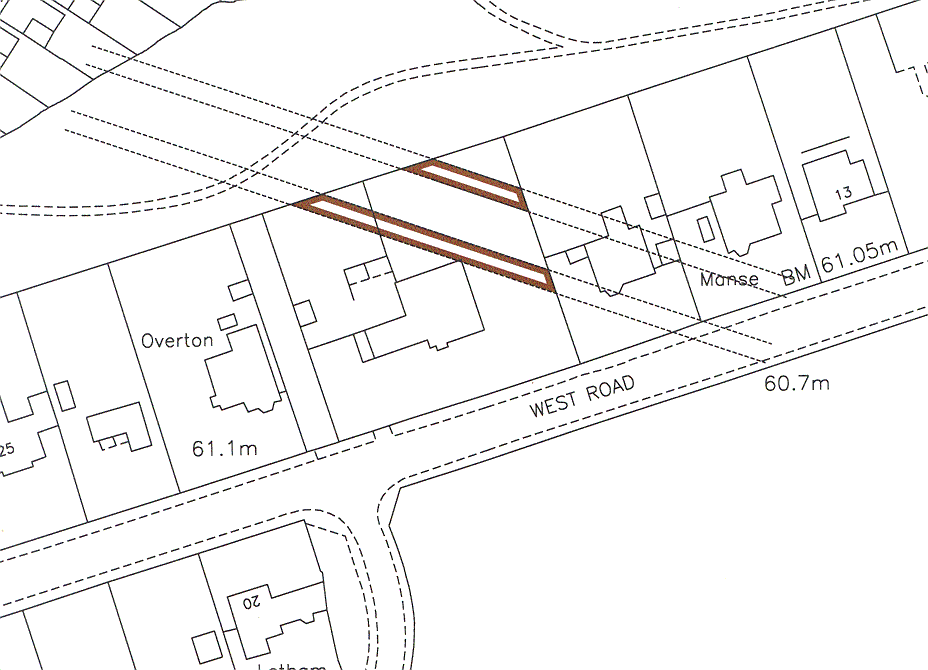
8.4.13 Underground Railways or Waterways
In acquiring land for Underground Railways, the transport authorities normally adopt a form of Deed whereby they acquire the sub-soil of the proposed tunnel etc. On the registration of such a title the following note will be made on the Index Map:
"TITLE NO ......... includes only part of parcel (subsoil of Underground Railway)". A similar note will need to be entered against the title from which the underground railway is excluded.
The method of showing land forming part of an underground railway on the Title plan of a title is shown below. Newlyn Datum may also be used and if it is the case should be referred to an appropriate senior officer.
8.4.14 "Exclusive Use" Of Premises
When a Conveyance of a dwellinghouse also grants to the purchaser "the sole use" or "the exclusive use" or "an exclusive right of user" of other premises such as a W.C. or coal shed or garage or wash-house or ash- pit, the grant does not constitute a servitude. Unless the context clearly suggests otherwise such wording operates to dispone the premises in question but not the air space or any other part of the structure above them nor the ground or other parts of the structure beneath them.
Mapping will be completed by giving a reference for the part or parts so granted, but where the whole subjects are being mapped precise extent, the said part or parts will not be red edged. Site plan and tinting method cases will be completed as normal.
The premises in question will, be included in the Title Sheet by using the phrase "together with" following the description of the property and then incorporating, if possible, the words of the deed referring to the premises to be exclusively used, for example: -
20 OBSERVATORY ROAD, EDINBURGH edged red on the Title Plan, together with the exclusive right to use the wash-house tinted pink and the coal shed tinted yellow on the said plan.
Plans Staff will make the entry in the A. Property Section when completing the case.
Where, however, the rights exclusively granted are lengthy or complex, and particularly, where there are pertinents to be entered on the Title Sheet as well, Plans Staff will not make an entry in the A. Property Section but will inform Legal Staff of the references shown on the Title Plan for example: -
The parts coloured pink, yellow and blue on the plan to writ number 6 are similarly referenced on the Title Plan.
When a writ dispones property subject to the exclusive rights of use then the wash-house, coal-shed or other premises must be excluded from the registered title by a note in the A. Property Section for example: -
NOTE: The exclusive use of the wash-house tinted blue on the Title Plan is excepted from the title.
In this case the actual premises (i.e. the wash-house) are excepted from the title but the air space and ground beneath are not. Consequently in dealing with title plans being mapped precise extent method, the land is included in the red edging, and a colour reference and A. Property Section Note prepared as above.
Related content
*
This is the registration manual for 1979 casework.
Do not under any circumstances use the information here when settling 2012 casework. This resource has been archived and is no longer being updated. As such, it contains many broken links. Much of the information contained here is obsolete or superseded.
*
The Manual is an internal document intended for RoS staff only. The information in the Manual does not constitute legal or professional advice and RoS cannot accept any liability for actions arising from its use.
Using this website requires you to accept cookies. More information on cookies.