Boundary Juts in OS Large Scale Mapping
- Editor9
- RPT Admin (Unlicensed)
Boundary Juts
When comparing the Ordnance Survey (OS) map with detailed plans for individual properties which are often produced at 1:500 or 1:250 scale, it is important to understand when small juts in boundaries will and will not be depicted on the OS map.
We are all aware that great care must be taken in determining the registered extent of a cadastral unit as errors can result in the Keeper having to pay compensation in the event of actual loss caused by an error. It should also be borne in mind that whilst such errors create additional work for RoS, they may in fact cause considerable inconvenience and hardship to either the applicant or an adjoining proprietor. Boundary decisions by plans settlers require the exercise of sound judgement, based on a good working knowledge of the law relating to property boundaries, together with a clear understanding of the rules and principles which govern the preparation of the various large scale Ordnance Maps. This knowledge must at all times be supported by the application of a structured decision making process.
There will be many occasions where the Ordnance Survey map does not agree with the deed plan supplied. This can be for many reasons; some of these reasons are concerned with the specification of the map, some result from scale differences, and some from limitations of the data capture method.
Example 1
In this example the 1:200 scale deed for a property reveals a 1m gap between the House and fence and a 0.9m jut in the fence itself
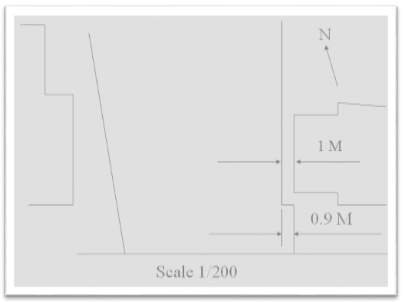
Due to the limitation of the map at 1:2500 the OS have not shown the double feature between the house and the fence, nor has the jut in the fence been shown.
So how should this cadastral unit be mapped? The following guidelines should help in making the right decision.
OS Guidelines for defined features containing external boundary juts
Whilst the OS do not publish rules for when a jut in an external boundary should be depicted on the map, the following can normally be accepted as a guide:
- If a jut is larger than 1m at 1:1250, 2m at 1:2500 or 5m at 1:10 000 then the jut should be shown on the OS map
- Where the jut is less than 0.2m at 1:1250, 0.4m at 1:2500 or 1.8m at 1:10 000 the jut will not be depicted on the OS map
- If the jut measures somewhere between the two measurements above then it is at the discretion of the OS surveyor as to whether the jut is depicted on the map
Example 2
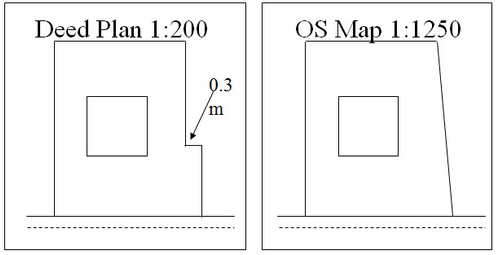
- If the boundary feature is depicted on the OS Map and the jut is not shown as part of the feature as it is outwith the OS criteria for the base scale, then the registered extent of the subjects should be mapped following the defined OS feature
Example 3
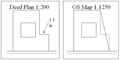
If the boundary feature is depicted on the OS Map and the jut is not shown as part of the feature although it is within the OS criteria for the base scale, then the registered extent of the subjects should be mapped plotting the jut to reflect the extent of legal title
Guidelines for un-defined features containing external boundary juts
If there is no boundary feature depicted on the Ordnance Survey map and the jut is equal to or greater than:
- 0.2m at 1:1250
- 0.4m at 1:2500
- 1.8m at 1:10,000
then the cadastral unit should be mapped to show the jut. If the jut is less than the above distances then the cadastral unit should be mapped without showing the jut.
Registers of Scotland (RoS) seeks to ensure that the information published in the 2012 Act Registration Manual is up to date and accurate but it may be amended from time to time.
The Manual is an internal document intended for RoS staff only. The information in the Manual does not constitute legal or professional advice and RoS cannot accept any liability for actions arising from its use.
Using this website requires you to accept cookies. More information on cookies.
Feedback