/
List of OS Defined Rural Towns
List of OS Defined Rural Towns
- Editor9
Owned by Editor9
Jan 22, 2016
Analytics
Loading data...
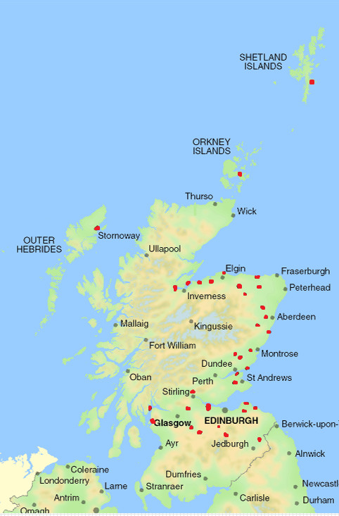
Below is the list of Defined Rural Towns supplied by the Ordnance Survey (list current at January 2016). The approximate location of each of these towns is marked in red on the map, right.
- Avoch, Black Isle - ROS.
- Banchory - KNC.
- Banff & MacDuff - BNF.
- Beauly - INV.
- Bo'ness - WLN.
- Brechin - ANG.
- Carnoustie (including Barry) - ANG.
- Cupar - FFE.
- Dunbar - ELN.
- Dunblane - PTH.
- Dunoon - ARG.
- Forfar - ANG.
- Forres - MOR.
- Fortrose, Black Isle - ROS.
- Haddington - ELN.
- Huntly - ABN.
- Inverurie - ABN.
- Keith - BNF.
- Kelso - ROX.
- Kilsyth - STG & DMB.
- Kirkwall, Mainland, Orkney - OAZ.
- Kirriemuir - ANG.
- Lanark (including New Lanark) - LAN.
- Largs - AYR.
- Larkhall - LAN.
- Lerwick, Mainland, Shetland - OAZ.
- Linlithgow - WLN.
- Lossiemouth - MOR.
- Muir of Ord - ROS.
- Nairn - NRN.
- Newport-on-Tay (including Wormit) - FFE.
- North Berwick - ELN.
- Peebles - PBL.
- Rosemarky, Black Isle - ROS.
- Stonehaven - KNC.
- Stornaway, Isle of Lewis - ROS.
- Turriff - ABN.
- Westhill - ABN.
- West Linton - PBL.
, multiple selections available,
Registers of Scotland (RoS) seeks to ensure that the information published in the 2012 Act Registration Manual is up to date and accurate but it may be amended from time to time.
The Manual is an internal document intended for RoS staff only. The information in the Manual does not constitute legal or professional advice and RoS cannot accept any liability for actions arising from its use.
Using this website requires you to accept cookies. More information on cookies.
Feedback