Enlargements or Enlarged Plans in Previously Mapped Titles
- Editor9
Why did we previously use enlargements or enlarged plans?
- Many enlargements contain additional detail, label references or plotting that will be lost if they are simply deleted.
- Often, enlargements were used to show very small plans references that could not be clearly seen when printed at base scales of 1:2,500 or 1:10,000.
- The enlargement boxes were used to show extents of properties on different floor levels.
- The enlargement boxes were used to show Enlarged Plans, which showed RoS plotting of features that did not agree with the OS base map that was current at that time.
- The enlargement boxes were used to show Inset Plans, which showed the OS base map at a smaller scale, perhaps to show a single reference that covered a large area.
- If all enlargements are automatically deleted without thorough consideration, a lot of detail in existing 1979 Act title sheets will be lost.
How do we now update titles with enlargements or enlarged plans?
Enlargements and enlarged plans in existing titles will be imported to the Plan Creator from DMS as groupings. Each enlargement will be created as a separate group, and the group will be automatically given the name of the enlargement in the DMS. The following rules have been established for updating such titles.
After updating the title appropriately in the Plan Creator, following the guidance below, the plans officer should add title note(s) on the LRS informing the legal officer of any change to the way a reference should be narrated in the title sheet.
Enlargements
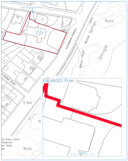
- Straightforward enlargements. If the enlargement had purely been used to enlarge part of the title due to visibility when printed at base map scale, and there would be no loss of mapped detail or information, then the grouping containing the former enlargement can be deleted. As extracts of the cadastral map are now provided as pdf files which allow the viewer to zoom in, there is no longer a requirement for the enlarged detail.
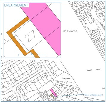 | In this example, the enlargement box had been used to show the detail of the narrow path, etc that would not have been easily seen when printed at 1:2,500 base scale. It is a duplicate of what was being shown on the main title, just shown at a different scale. The new grouping now containing the enlarged detail can be deleted as all the mapping detail is shown on the primary layer of the cadastral map and can now be seen by the customer by zooming in to the pdf file provided to them. Any text or labels brought forward relating to the enlargement should also be deleted. |
| In this example, the enlargement box had been used to show very small detail that would not have been easily seen when printed at 1:2,500 base scale. It is a duplicate of what was being shown on the main title, just shown at a different scale. The new grouping now containing the enlarged detail can be deleted as all the mapping detail is shown on the primary layer of the cadastral map and can now be seen by the customer by zooming in to the pdf file provided to them. Any text or labels brought forward relating to the enlargement should also be deleted. |
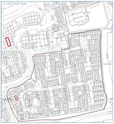 | In this example, we have a reversed scenario with the enlargement box having been used to show the detail of house plot at 1:1,250 base scale, but with the large deed of conditions reference being shown on the main title with the print scale manually set to 1:10,000 to allow it to be printed on a single A4 page. The house plot detail is duplicated on both the enlargement and the main title, just shown at different scales. The new grouping now containing the enlarged detail can be deleted as all the mapping detail is shown on the primary layer of the cadastral map and can now be seen by the customer by zooming in to or panning around the pdf file provided to them. Any text or labels brought forward relating to the enlargement should also be deleted. |
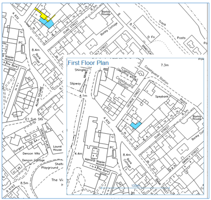
2. Floor level plans. If the enlargement(s) had been used to show floor levels, then the detail in each enlargement will now be contained in a grouping within the Plan Creator. These groupings should be retained, renamed, and the detail contained within them classified accordingly. Depending on the content of each of the former floor level plans, it may be possible to reduce the number of groupings if the references are co-extensive on two floors, for example.
If the floor level grouping(s) relate to a tenement scenario, then the grouping will be described as 'supplementary data'.
If the floor level grouping(s) relates to a non-tenement scenario (for example, a pend), then the grouping will be described as 'additional cadastral map view'.
See the Further Guidance page on Groupings for more detail on naming conventions.
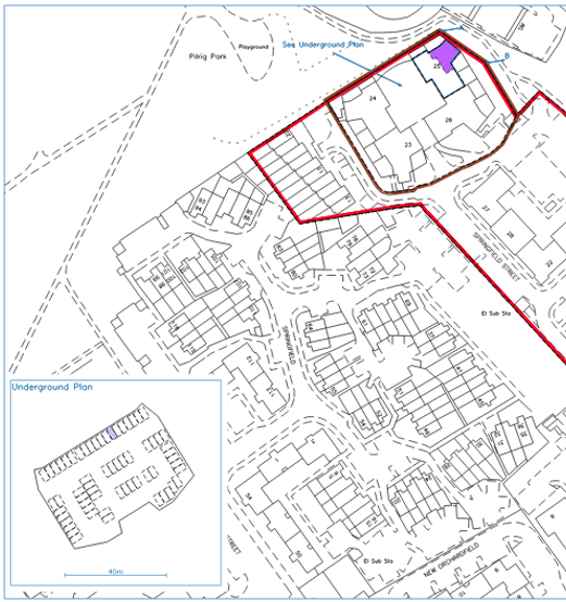
| In this example, the enlargement box had been used to show the detail on the first floor of a flatted property. The new grouping now containing the first floor detail should be retained, categorised, renamed to use the title number with a suffix (for example, LAN87654-1 or LAN87654-2), and will be referred to in the title sheet as supplementary data 1 (or 2). Any text or labels brought forward relating to the enlargement should also be deleted. If the whole title is being updated to a 2012-Act style, then the tenement steading cadastral unit will be shown on the primary ungrouped layer of the cadastral map, with all detail pertaining to the flat shown on grouping(s) containing supplementary data. |
 | In this example, the enlargement box had been used to show the detail of an underground parking level located under several blocks of flats. The new grouping now containing the underground car park detail should be retained, categorised, renamed to use the title number with a suffix (for example, MID24680-1 or MID24680-2), and will be referred to in the title sheet as supplementary data 1 (or 2). The polygons for the other parking spaces which have been added for clarity should be categorised "For Reference Only". Any text or labels brought forward relating to the enlargement should also be deleted. If the whole title is being updated to a 2012-Act style, then the tenement steading cadastral unit will be shown on the primary ungrouped layer of the cadastral map, with all detail pertaining to the flat & parking space shown on grouping(s) containing supplementary data. |
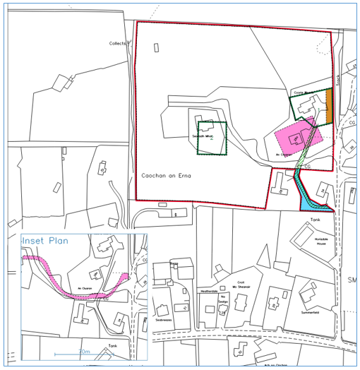
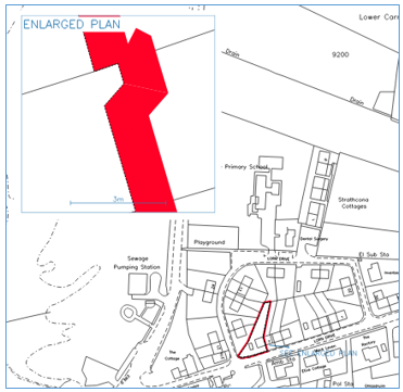
3. Inset plans. If the enlargement had been used to show references that are not on the main title plan, such as an Inset Plan, then the title will need to be re-organised following the guidance on the appropriate use of Groupings. It may be appropriate to retain the new grouping as an additional cadastral map layer/view and rename it, or it may be more appropriate to move the detail into the ungrouped primary layer of the cadastral map and delete the grouping. Each case should be considered on its own merits; if you are unsure, please discuss with your plans referral officer in the first instance.
| In this example, the enlargement box had been used as an Inset Plan to show one or more plans references that would have made the main title plan layer complex and look cluttered. Following the guidance on the appropriate use of Groupings, the new grouping now containing the former inset plan detail can be retained, re-named, categorised, etc., or the mapping of the whole title can be re-organised depending on what is most appropriate for the particular case. In scenarios such as this, any groupings used to show burdens references, etc to make the view of a complex title clearer will be referred to in the title sheet as being on the additional cadastral map view. Any text or labels brought forward relating to the enlargement/inset plan should also be deleted. |
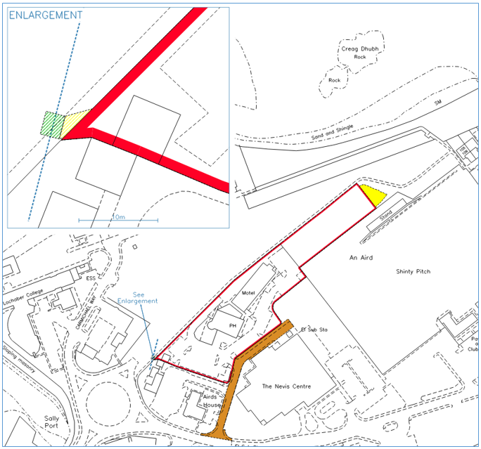
| In this example, the enlargement box had been used as an Inset Plan to show one or more plans references that covered a large area and would have made the main title plan layer print on multiple pages at base scale. The large reference shown in the former inset plan can now be seen by the customer by zooming out or panning around the pdf file provided to them. Following the guidance on the appropriate use of Groupings, the new grouping now containing the former inset plan detail can be retained, re-named, categorised, etc., or the mapping of the whole title can be re-organised depending on what is most appropriate for the particular case. In scenarios such as this, any groupings used to show burdens references, etc to make the view of a complex title clearer will be referred to in the title sheet as being on the additional cadastral map view. Any text or labels brought forward relating to the enlargement/inset plan should also be deleted. |
Enlarged Plans
In the DMS it was possible to turn off the background OS map in an enlargement box when printing a Title Plan - this allowed the plans officer to plot additional small detail as per the deed plan if the generalisation built into the OS map was deemed insufficient to show the boundaries of the subjects. These were known as Enlarged Plans.
When migrated into the Plan Creator, these Enlarged Plans will be assigned to groupings, but the Mastermap OS layer will be visible and cannot be turned off when viewing or printing. All cases with Enlarged Plans will need to be re-worked when migrated to the Plan Creator, and all should be referred to a Plans HEO for consideration.
Consideration will need to be given to whether the additional small detail is actually needed (taking into account the tolerances of the OS base map scale), whether a new map version is now available that helps show the boundaries in more detail, whether the plotting of that boundary on the primary ungrouped layer can be amended to include the small detail formerly in the Enlarged Plan since the viewer is now able to zoom in whilst viewing the title, whether in rare cases an OS P24 re-survey is required, etc. Each case will need to be considered on its own merits.
| In this example, the enlarged plan has been used to show a very small jut at the front of the property in the boundary with the neighbouring house in the block. The black lines in the enlarged plan box are not actually the underlying OS map, but are black lines drawn by the plans officer to illustrate the more detailed shape of the boundary taken from the deed plan. These drawn lines will be brought forward into the grouping with the rest of the former enlarged plan detail. As the viewer is now able to zoom in when viewing the pdf title, it may be possible in this particular example to incorporate this plotting into the primary ungrouped title layer and delete the grouping showing the former enlarged plan detail. However, the tolerances of the base map should be considered when making decisions such as this. |
 | In this example, the enlarged plan has been used to show the boundary between two properties in more detail. As is common with two boundary features lying very close together, they have been generalised into a single feature in the OS map. The black lines in the enlarged plan box are not actually the underlying OS map, but are black lines drawn by the plans officer to illustrate the more detailed shape of the boundary taken from the deed plan. These drawn lines will be brought forward into the grouping with the rest of the former enlarged plan detail. Since many areas have been re-surveyed in recent years by the OS with a higher level of accuracy, it may be that there is a newer version of the map available now that shows the boundaries between these properties in more detail, thus allowing the cadastral unit to be remapped in the primary ungrouped layer without the loss of any of the detail formerly shown in the Enlarged Plan. |
Registers of Scotland (RoS) seeks to ensure that the information published in the 2012 Act Registration Manual is up to date and accurate but it may be amended from time to time.
The Manual is an internal document intended for RoS staff only. The information in the Manual does not constitute legal or professional advice and RoS cannot accept any liability for actions arising from its use.
Using this website requires you to accept cookies. More information on cookies.
Feedback