Mapping Salmon Fishings
- Editor9
Key points for plans settlers
The plans registration process for a salmon fishings title is very similar to that for the registration of an area of ground. The key points and differences are set out below.
- The cadastral unit can be mapped in the same manner as cadastral units for areas of ground, using a red edge or tints depending upon which is most appropriate for the particular cadastral unit. In rare cases, it may also be necessary to map linear water features with a broken (blue) line - see below for details of when this style is appropriate and seek Senior Advisor approval before adopting this mapping style.
- There are several acceptable ways of describing and registering a salmon fishings title:
- The most common style is when the precise extent of the salmon fishings is provided in the deed, and this is used to map the cadastral unit. The subjects are described in the title sheet as being that cadastral unit.
- It is also possible to register salmon fishings within the sea. These salmon fishings applications must meet the same requirements as applications to register seabed plots - Description of seabed plot must be acceptable. Salmon fishings titles in the sea will also be mapped in the same manner as seabed plots - see Mapping seabed for further guidance.
- Occasionally, the deed will describe the salmon fishings by reference to a larger area (see Salmon fishing rights within an estate, below), and this larger area is used to map the cadastral unit. As the fishings comprise less than the full geographical extent of the cadastral unit, the subjects are described in the title sheet as being part of that cadastral unit.
- Salmon fishings titles can include rights (such as rights of access) or be burdened by encumbrances. As with applications to register other types of legal tenement, this information will be included in the deeds and the application form, and the same guidelines on acceptability, etc apply. See Plans references for rights, burdens and servitudes for more general guidance on this.
- The polygons should be classified as Ownership of Salmon Fishings (for ownership) or Lease when only the tenancy of salmon fishings is being registered.
- The real right field in the property section of the title sheet will be Ownership or Tenancy - the fact that it is ownership or tenancy of salmon fishings is disclosed in the property description itself, not in this field.
- If the salmon fishings title sheet is for the real right of ownership, the hectarage of the cadastral unit should be entered in the property section of the title sheet when the area of the cadastral unit is 0.5 hectares or is greater than 0.5 hectares.
- The hectarage of the cadastral unit is not entered if it is the tenant's right in a lease of the salmon fishings that is being registered.
- When entering the property description into the property section of a salmon fishings title sheet, the right to the fishings must be included as well as a description of the area. See Sample Property Section Styles - Salmon Fishings for examples of property sections relating to salmon fishing titles.
- If the area of ground underlying the fishings is already registered in the land register (the separate tenement to the land), the Keeper is obliged to disclose the title numbers in the property section of the title sheet (a Schedule of Separate Tenements will be added by the legal settler). There is no requirement for a reference to be added to the cadastral map for the extent of the "land" titles. The plans officer should include a note in the title notes to the legal settler on the LRS giving the title number(s). If your application is an FR, then this information can be added to the FR Remarks to Legal template under Existing Registrations.
- For example, "PTHxxx - land"
- For example, "PTHxxx & PTHyyy - land".
Salmon fishing rights within an Estate
The extent of the salmon fishing rights may be described in the deeds or VR application as being within the extent of the original estate or a large area, rather than a specific area of salmon fishing rights in a body of water or a linear reference along a particular river or other watercourse (see section below on linear references). Examples of this type of wording are:
- the right of fishings of salmon in the streams within the land hereby disponed
- the right to fish for salmon in all rivers, streams, ponds, etc within the Dunelm Estate edged blue on the deed plan
- the whole salmon fishings in all waters in the land hereby disponed or bounded thereby including the River Tweed.
For the majority of applications for registration of this scenario, the extent of the underlying property title/plot of ground will be the same as the extent of the salmon fishing title created, i.e. one property title = one salmon fishing title, and therefore the noting of the separate tenement only affects those two titles. There are however scenarios where the extent of the estate submitted for the salmon fishing title extends over multiple registered property titles for plots of ground. Not all of those property titles will be affected by watercourses, either within the extent of the property title, or abutting it.
Registration practice is only to note the separate tenement of salmon fishing against those property titles for plots of ground that either have a water course passing through it or abutting it. or a body of water forming part of it or abutting it.
The plans officer (HEO) is required to provide the legal settler with the property title numbers of only those registered plots of ground that lie within the extent of the salmon fishing application that either have a water course passing through it or abutting it. or a body of water forming part of it or abutting it. The Cadastral Check tool in Plan Creator will provide a list of all titles within the salmon estate extent which can then be examined in relation to the underlying Ordnance Survey map.
Any queries regarding specific titles should be referred to Plans SEO for consideration.
Mapping salmon fishings from a deed plan that shows linear references
Very occasionally, an agent will submit a deed conveying salmon fishings (or a voluntary registration of salmon fishings) in which they are described as being, for example, "the right to fish for salmon within those rivers, burns, streams, etc shown lined in blue on the plan". This style of referencing may also be used in combination with references for areas (for example, lochs, lochans or ponds) which are shown shaded or outlined on a plan.
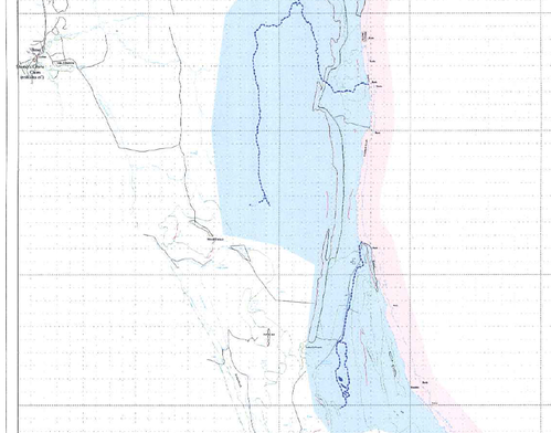
|
| This deed plan (or plan accompanying a VR application) shows with dark blue lines the specific rivers and streams within which there are salmon fishing rights. |
As such applications are rare, they should be referred to a Plans Senior Advisor for consideration before proceeding with the mapping of the application. If approval is given by the Plans Senior Advisor, the linear features lined on the plan should be mapped in the following ways:
- If the river or stream is shown with a double-banked feature on the OS map, a polygon should be drawn following the double-banks, and edged, or filled with a tint or hatch, as appropriate.
- If the river or stream is shown with a single line feature on the OS map, a polyline (using the line button) should be drawn following the OS feature, and a blue line applied in the Plan Creator. If necessary, the ends of the the lines can be labelled (for example, shown with blue lines between A & B in blue, and C & D in blue).
Leases of salmon fishings
As salmon fishings are capable of being owned and registered as a separate tenement, it is also possible to grant and register a lease of salmon fishings. A lease of salmon fishings will also have its own title sheet, in accordance with the Keeper's policy in relation to leases. If the ownership of the salmon fishings is not already registered, registration of a tenant's right to those salmon fishings will trigger automatic plot registration (APR) under section 24 of the 2012 Act. In this instance, however, the plot that will be registered is the separate tenement of salmon fishings. As with dispositions of salmon fishings, the registration process for dealing with leases of salmon fishings is very similar to that for dealing with leases of ground. See Mapping Leases and Automatic Plot Registration - plans guidance for more general guidance on those subjects.
Registers of Scotland (RoS) seeks to ensure that the information published in the 2012 Act Registration Manual is up to date and accurate but it may be amended from time to time.
The Manual is an internal document intended for RoS staff only. The information in the Manual does not constitute legal or professional advice and RoS cannot accept any liability for actions arising from its use.
Using this website requires you to accept cookies. More information on cookies.
Feedback