Mapping a Flat With Parking in Another Block
- Editor9
The agreed practice described immediately below should only be applied when the block of flats and the parking block form part of the same development. If the owner of a flat has acquired a parking space or garage outwith the development (perhaps located in another development, or simply a separate garage located in the neighbourhood), then such properties will be treated as two cadastral units with two title sheets. See the Further Guidance page Mapping a Flat or House with Remote Parking or Parking in Another Development for more detail.
Key points for plans settlers
- A separate plans reference is required on the cadastral map for the parking block so that it can be referred to in the restrictive note. For example, the cadastral unit is edged red (block of flats) & edged blue (parking block). Both of these references will be shown on the primary ungrouped layer of the cadastral map and both will be classified as Tenement Steading.
- A separate plans reference is required on the cadastral map for that part of the parking block included in (or excluded from) the cadastral unit so that it can be referred to in the restrictive note. For example, the integral garages tinted blue on the ground floor of the parking block. Again this reference will be shown on the primary ungrouped layer of the cadastral map and will be classified as Exception.
- The restrictive note should be added to the property section notes in the title sheet on the LRS.
- The extent of the tenement steading cadastral unit is established in the same way as with other blocks of flats in developments - see Identifying the Tenement Steading Extent. The only difference is that some of the pertinents of the flats in the block are located within another (parking) block, so a plans reference on the cadastral map is required for both blocks.
- If it is not possible to establish all the parking spaces,etc pertaining to all the flats in the block from the information available, it is possible to set up a tenement steading cadastral unit with a restricted extent. The only difference is that it will be necessary to update both the tenement steading cadastral unit/restrictive note for the block of flats and the residue of the parking block (if the residue of the parking block has already been set up as a tenement steading cadastral unit).
- The development common areas, etc (those shared by the flats in more than one block) are treated in the same way as other developments - see Mapping Common Areas and Mapping & Updating Deeds of Conditions.
Scenario
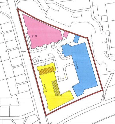
- The development comprises 3 blocks - 2 blocks are made up of only flats, whilst the 3rd is made up of flats and also a ground floor parking level.
- A deed of conditions affects the whole development, and this is edged brown on the cadastral map.
- Most of the flats in Block A have their parking spaces within Block C, however 3 flats have outside parking spaces. The solum of Block A together with those 3 outside spaces has been tinted pink.
- Most of the flats in Block B have their parking spaces within Block C, however 4 flats have outside parking spaces. The solum of Block B together with those 4 outside spaces has been tinted blue.
- All of the flats in Block C have their parking spaces within Block C. The solum of Block C has been tinted yellow.
- Those parking spaces in the ground floor parking level within Block C that pertain to flats in Block A have been hatched brown.
- Those parking spaces in the ground floor parking level within Block C that pertain to flats in Block B have been hatched blue.
The subjects comprise the westmost 2nd floor flat in Block A together with parking space no. 17 in the ground floor parking level of Block C.
The tenement steading cadastral unit, and references pertaining to the whole of Block A are shown on the primary ungrouped layer of the cadastral map as usual.
The tenement steading cadastral unit for Block A comprises the block and ground tinted pink, and the block tinted yellow:
- "Subjects part of cadastral unit KNC1234 tinted pink and yellow on the cadastral map being the westmost flat on the 2nd floor......"
A restrictive note is required to clarify that only part of the block tinted yellow (Block C) is included within the tenement steading cadastral unit:
- "As to the part tinted yellow on the cadastral map, only the parking spaces hatched brown on the ground floor parking level are included in this cadastral unit."
A grouping containing supplementary data is used as normal to show the plans references needed for pertinents of the flat.
- In this example, the deed for extent included a plan showing the extent of the flat on the 2nd floor of Block A and the extent of parking space no.17 in the ground floor parking level of Block C, so these plans references would be shown in the grouping containing the supplementary data.
The subjects comprise the northmost ground floor flat in Block B together with outdoor parking space B2.
The tenement steading cadastral unit, and references pertaining to the whole of Block B are shown on the primary ungrouped layer of the cadastral map as usual.
The tenement steading cadastral unit for Block B comprises the block and ground tinted blue, and the block tinted yellow:
- "Subjects part of cadastral unit KNC5678 tinted blue and yellow on the cadastral map being the northmost flat on the ground floor......"
- Please note that, even though the flat in this example does not have a parking space within Block C, the tenement steading cadastral unit is set up so that it can be used for the registration of all flats within Block B.
A restrictive note is required to clarify that only part of the block tinted yellow (Block C) is included within the tenement steading cadastral unit:
- "As to the part tinted yellow on the cadastral map, only the parking spaces hatched blue on the ground floor parking level are included in this cadastral unit."
A grouping containing the supplementary data is used as normal to show the plans references needed for pertinents of the flat.
- In this example, the deed for extent included a plan showing the extent of outdoor parking space B2, so this plans reference would be shown in the grouping containing the supplementary data.
- The extent of the flat on the ground floor of Block B was not shown on the deed plan, but the verbal description was sufficient for registration purposes.
The subjects comprise the southmost 1st floor flat in Block C together with parking space no. 5 in the ground floor parking level of Block C.
The tenement steading cadastral unit, and references pertaining to the whole of Block C are shown on the primary ungrouped layer of the cadastral map as usual.
The tenement steading cadastral unit for Block C comprises the block tinted yellow:
- "Subjects part of cadastral unit KNC9182 tinted yellow on the cadastral map being the southmost flat on the 1st floor......"
A restrictive note is required to clarify that some parts of the block tinted yellow (Block C) are not included within the tenement steading cadastral unit:
- "As to the parts hatched blue and brown on the cadastral map, the parking spaces on the ground floor parking level are not included in this cadastral unit."
A grouping containing the supplementary data is used as normal to show the plans references needed for pertinents of the flat.
- In this example, the deed for extent included a plan showing the extent of the flat on the 1st floor of Block C and the extent of parking space no.5 in the ground floor parking level of Block C, so these plans references would be shown in the grouping containing the supplementary data.
FAQs
Why do I have to include the whole of the parking block in the mapping and then restrict the extent included within the cadastral unit with the note?
The majority of developments like this will be subject to a deed of conditions. It is likely that in that deed of conditions, the owners of all the parking spaces and the flats in the parking block are subject to rights and obligations that affect the whole of the parking block (for example, rights of access, a right in common to the solum, obligations not to obstruct access, and maintenance cost obligations). Therefore a plans reference for the whole block is required. The note (and separate plans references for the parking spaces) is required since only those parts pertaining to our block of flats can be included in the tenement steading cadastral unit for that block of flats.
Why can't we just call the whole development the tenement steading cadastral unit?
The terms of the 2012 Act, section 16 (Tenements and other flatted buildings) refer to single tenement buildings, they do not refer to developments of blocks of flats. Therefore, section 16 means we have to set up a tenement steading cadastral unit for each block of flats.
Why can't we split the application into two titles - one for the flat and one for the parking space?
This is an approach that could be used but only in very exceptional circumstances - agreement must be reached with a senior plans advisor before this can be done. The main issues with using this approach would be that:
- the applicant would then be faced with two registration fees in all future applications affecting their property; and
- all the rights and burdens affecting the property would have to be reconsidered by the Keeper's legal officers to see which affected the flat and which affected the parking space.
Registers of Scotland (RoS) seeks to ensure that the information published in the 2012 Act Registration Manual is up to date and accurate but it may be amended from time to time.
The Manual is an internal document intended for RoS staff only. The information in the Manual does not constitute legal or professional advice and RoS cannot accept any liability for actions arising from its use.
Using this website requires you to accept cookies. More information on cookies.
Feedback