FR - Using an Existing Tenement Steading Cadastral Unit
- Editor9
General
Under the 2012 Act there can be no registration without mapping, and in order to complete registration, the Keeper must create a cadastral unit for the plot of land being registered. Section 16 of the 2012 Act provides an exception to this rule, but only in so far as the extent of the individual flats and units within a tenement building, flatted building or other sub-divided building. Using section 16, the Keeper can represent a tenement, or other sub-divided building, and all the registered flats within it as a single cadastral unit on the cadastral map - this cadastral unit defines the extent of the tenement steading within which all the flats, their rights and pertinents are contained. This is known as the tenement steading cadastral unit.
Each registered flat within the building will still have its own, unique title sheet, however the property section of each of these title sheets will refer to the flat as forming part of the tenement steading cadastral unit. If plans references are required for the extent of the flat on a particular floor level, an area of exclusive or common ownership within the tenement steading, or for a pertinent of that flat, these will be shown on a separate grouping or layer that shows supplementary data for the individual flat.
A tenement steading cadastral unit will be set up by the Keeper upon receipt of the first 2012 Act application for first registration of a flat within a tenement or other sub-divided building - this applies whether there is an existing 1979 Act registration of a flat or not. Later applications to register other flats or units within that tenement will be registered with their own, unique title sheets - these title sheets will make reference to the flat or unit forming part of the existing tenement steading cadastral unit. Any existing 1979 Act registrations for flats within the tenement will be converted at a future date as part of a conversion process so that they also refer to the tenement steading cadastral unit. Where possible, the tenement steading cadastral unit will comprise the extent of all flats, their rights and pertinents. If this is not possible, provided certain requirements are met, a restricted extent can be set up comprising the extent of all registered flats, their rights and pertinents; if a restricted extent is used, it may be updated by the keeper to include any additional areas of ground registered as part of future applications to register other flats in the same tenement.
Requirements for applications within tenements
There are two fundamental requirements that must be met before the Keeper will proceed any further with an application to register a flat or unit in a tenement steading. These are:
- Tenement steading extent. if the Keeper does not already hold an acceptable extent for the tenement steading, either (1) a plan or suitable description of the extent of the full tenement steading cadastral unit, or (2) a plan or suitable description of the tenement building itself, and of all the rights and pertinents of the flat that are located outwith the building must be supplied in the application - See Further Guidance on acceptable deed plans, bounding descriptions and identifying the tenement steading extent; and
- Unique flat description. A plan or suitable description of the individual flat that allows the flat to be differentiated from all other flats in the building must be supplied with the application - see Further Guidance on acceptable descriptions of flatted property.
If either of these two requirements is not met, the application should be considered for rejection as the application does not comply with the conditions of registration.
Once it has been established that these two requirements are met, further consideration can then be given to the particulars of the application and how it should be plans settled.
Using an existing tenement steading cadastral unit - key points for plans settlers
Use the FR tenement flow chart to check if there is an existing tenement steading cadastral unit that you should use.
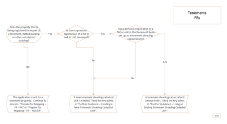
Visio 5016- If the result in the flow chart that fits your application is "A tenement steading cadastral unit already exists", the following guidance contains the key points to be borne in mind when using an existing tenement steading cadastral unit.
- You will have been directed to this Further Guidance page if the property being registered is the second (or later) 2012 Act registration of any unregistered flat or unit within the tenement.
- Any 1979 Act PRs will be converted at a future date.
- The title sheet number allocated to the current application for registration will not change. The cadastral unit number of the existing tenement steading cadastral unit will be referred to in the title sheet as the flat being registered forms part of that existing tenement steading cadastral unit. For example, REN1 is the cadastral unit number. The first flat is title number REN1 out of cadastral unit number REN1. The second flat is title number REN2 out of cadastral unit number REN1.
- With the current It provision, it is not possible to link more than one title sheet to an existing tenement steading cadastral unit - there is a one-to-one relationship between an application on the LRS and an application in the Mapping tools (plan Creator, etc). Because of this, you will need to map and authorise a copy of the tenement steading extent in the Plan Creator for every application to register a flat within that tenement. In the future, when the IT provision changes, these extra copies of the tenement steading extent may be removed & the title sheets linked directly to the original tenement steading cadastral unit - this will be a many to one relationship between applications on the LRS and a single application in the mapping database.
4.1 If the existing tenement steading cadastral unit was mapped with a restricted extent and the current application includes rights to additional areas of ground, refer to a referral officer to consider if it is appropriate to update the extent of the tenement steading cadastral unit.
4.2 If the extent of the tenement steading is also defined in the current application and that extent differs from the existing tenement steading cadastral unit for a reason other than 4.1, refer to a referral officer for further consideration.
4.3 In the Plan Creator, map the extent of the tenement steading cadastral unit onto the primary ungrouped layer of the cadastral map in the normal manner - consider if the 25 metre rule applies. Any plans references for rights and pertinents pertaining to the flat will be mapped on a separate grouping (or groupings if it is complex) showing supplementary data, and will not be mapped on the primary ungrouped layer of the cadastral map. This supplementary data will be referred to in the flat's title sheet as "supplementary data 1, supplementary data 2, etc" with the suffix reflecting the grouping number.
- The LRS title notes will be completed in the normal manner for a flatted property, and must also include a note identifying that the flat forms part of the existing tenement steading cadastral unit - Further Guidance on Completing the LRS Title Notes.
The property section of the title sheet will refer to the flat as forming part of the tenement steading cadastral unit. The details in the Cadastral Unit field in the property section header information will be changed manually to the tenement steading cadastral unit number.
- The Further Guidance pages found at Mapping Tenement Properties contain useful guidance on dealing with other aspects of registering flatted property.
- The User Guides Prepare for Mapping - FR Plans - RA - Tenement and Prepare for Mapping - FR Plans - Non RA - Tenement take you through the full process of plans settling flatted property (Please note, the user guides are still to be updated for Plan Creator processes).
Registers of Scotland (RoS) seeks to ensure that the information published in the 2012 Act Registration Manual is up to date and accurate but it may be amended from time to time.
The Manual is an internal document intended for RoS staff only. The information in the Manual does not constitute legal or professional advice and RoS cannot accept any liability for actions arising from its use.
Using this website requires you to accept cookies. More information on cookies.
Feedback