Monochrome Deed Plans
- Editor9
Not always a rejection - An application submitted with the extent defined on a monochrome plan does not automatically mean that the subjects cannot be identified and plotted onto the cadastral map
Key points to consider
Each application needs to be considered on its own merits, and as with any other extent plan, the usual considerations should be carried out by plans officers, including;
- Is there a full bounding description in support of the deed plan that can be used to identify and verify the boundaries shown on the monochrome plan?
- Are the subjects being registered fully bounded by registered titles, in which case a reasonable assumption, after due consideration and investigation, could be that the subjects adjoin those titles?
- Does the deed narrate other references in addition to the extent of the subjects, e.g. common areas, access routes? Can they be identified on the deed plan? If not, does it appear from examining registered titles that those references are shown in other registered titles? Is there any doubt or risk in the Keeper accepting those references from previous registrations?
- If the monochrome plan submitted with the application is a poor-quality copy of the original plan, check the Deed Search to see if a better copy exists.
- If a monochrome plan is submitted with the application, but a COF exists for a Plans Report based on the same deed, remember to check Reports Builder to see if a colour copy of the plan was submitted for the report.
One other point to remember, if registering a former council house disponed by Argyll and Bute Council, colour copies of these are held on archive in the LSVT folder.
Scenarios
Below are some examples of monochrome plans to illustrate what are acceptable and not acceptable with a brief explanation. When examining the plan submitted with an application, if you are unsure whether it is acceptable or not, please liaise with referral officers.
| Deed plan | Comments |
|---|---|
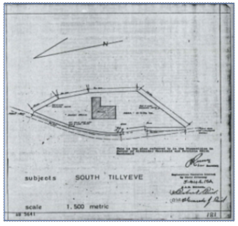
| This deed plan would be acceptable for registration. There are boundary dimensions shown for each boundary with sufficient surrounding detail from which to tie the features to the Ordnance Survey (OS) Map. |
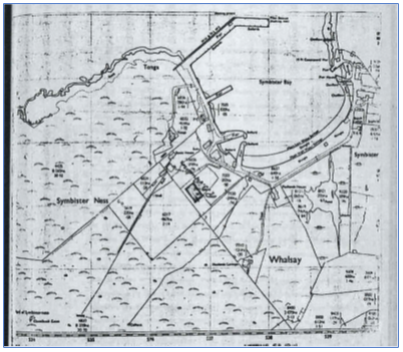
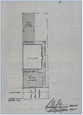
 | This deed plan may be acceptable for registration. Although there are no features shown on the deed plan apart from the building and road, if the subjects can be georeferenced in relation to those features and the boundaries scaled in relation to dimensions shown on the deed plan, then it could be acceptable. This is an example where a degree of investigation and consideration is required. |
 | This deed plan would not be acceptable for registration. Although there is nothing wrong with it being a monochrome plan, the deed plan is too small a scale and the boundaries not sufficiently defined to be accurately plotted. |
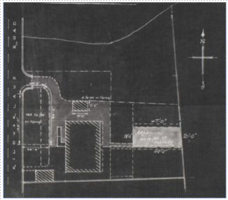
 | This deed plan would be acceptable for registration as the boundaries of the subjects can clearly be identified. Normal plans settle investigation to check if the boundaries shown on the historic county series map are defined and agree with those shown on the latest OS Map. |
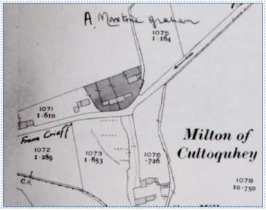
 | This deed plan would not be acceptable for registration. The problem is not the plan itself, or that it is reversed monochrome, as it has sufficient surrounding detail to identify the plot to be registered. Instead, the issue is that there are several other references shown on the plan, the colours of which cannot be identified from the monochrome plan. |
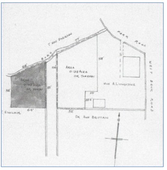
 | This deed plan would be acceptable for registration. Like Example 5, there are multiple references shown on the plan, however in this case there is sufficient information annotated on the plan, and along with the differences between the style of the references, which enables these to be identified and plotted on the cadastral map. |
Registers of Scotland (RoS) seeks to ensure that the information published in the 2012 Act Registration Manual is up to date and accurate but it may be amended from time to time.
The Manual is an internal document intended for RoS staff only. The information in the Manual does not constitute legal or professional advice and RoS cannot accept any liability for actions arising from its use.
Using this website requires you to accept cookies. More information on cookies.
Feedback