How to Map a Lease of Part
General
What is a Lease of Part?
When we talk about a lease of part - the "part" relates to the cadastral unit. So there are two scenarios where we register Leases of part:
- When the landlord's title is already registered and the lease that is submitted for registration as a TP affects only a part of the cadastral unit within that registered title, or
- When the landlord's title comprises all or part of a tenement, and the lease that is submitted for registration is for only a part of the tenement steading cadastral unit (e.g. a lease of a ground floor shop within a tenement block). Tenement lease of part scenarios are covered on a separate guidance page as the mapping style is different from a non-tenement lease of part.
Separate pages of guidance cover other scenarios such as Mapping a Lease of Whole, and Mapping a Sub-Lease.
Key points for Plans officers
Example of mapping style - lease of part
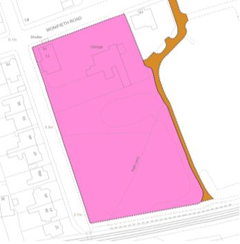
Landlord's title to the plot of land - before referencing the lease
The landlord's title to the plot of land is already registered in the land register.
The image, right, illustrates the cadastral unit as it it shown on the cadastral map - a pink tint for the cadastral unit extent (classified as Ownership - exclusive), and a brown tint for a servitude right of access (classified as Servitude).
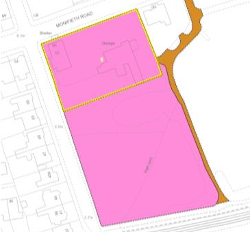
Landlord's title to the plot of land - after referencing the lease
As the lease is a lease of part (i.e. smaller than the cadastral unit), a plans reference is required on the cadastral unit to show that part of the plot of land that is subject to the lease. The extent of the leased subjects are shown edged and numbered 1 in yellow in this example (classified as Lease).
No plans reference for any other right, etc described in the lease will be referenced on the cadastral unit for the landlord's title.
The legal settler will add details of the lease to a Schedule of Leases in the title sheet for the landlord's title.
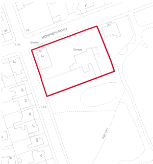
Tenant's title - what is shown on the cadastral map
Only the extent of the leased subjects is shown on the primary ungrouped layer of the cadastral map (classified as Lease). No reference is required for the extent of the landlord's title.
No plans reference for any other right, etc described in the lease will be referenced on the cadastral map or on supplementary data for the tenant's title. Instead, the lease itself (including any deed plans) will form part of the archive record and will be incorporated in the title sheet by reference to that deed.
Tenant's title - what is shown on supplementary data
As the lease is not a lease of part of a tenement property, there will be no requirement to provide any references in a grouping showing supplementary data.
No plans reference for any other right, etc described in the lease is referenced on the cadastral map or on supplementary data for the tenant's title.
Not applicable in this example
Registers of Scotland (RoS) seeks to ensure that the information published in the 2012 Act Registration Manual is up to date and accurate but it may be amended from time to time.
The Manual is an internal document intended for RoS staff only. The information in the Manual does not constitute legal or professional advice and RoS cannot accept any liability for actions arising from its use.
Using this website requires you to accept cookies. More information on cookies.
Feedback


