Measurement of Area (Hectarage)
- Former user (Deleted)
- Editor9
Analytics
How to obtain the area measurement of a cadastral unit
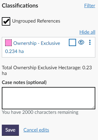
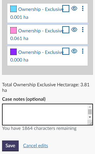
When a polygon has been styled and classified in the Plan Creator, the hectarage of the polygon will be automatically calculated and displayed in the left hand Classifications panel.
If a hole or island site has been cookie-cut out of a polygon in the Plan Creator, the area of the hole will have been automatically subtracted from the area measurement given for the polygon in the list.
In addition to displaying the areas of individual polygons, the Total Ownership Exclusive Hectarage is also displayed at the bottom of the list of references once all polygons in the list have been classified.
The area measurement of the individual polygons is shown to three decimal places, whilst the Total Ownership Exclusive Hectarage is rounded up or down automatically and is shown to two decimal places.
To achieve a consistent result, and to avoid accidental arithmetical errors, plans officers should use the Total Ownership Exclusive Hectarage figure as the basis for their title sheet entries rather than manually adding up the individual polygon figures.
Please see the section, below, for the rules on rounding up and down to be followed when entering the figures in the LRS fields.
Where to enter the area measurement in the property section
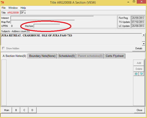
When the area of the cadastral unit is 0.5 hectares or greater than 0.5 hectares, this is to be included in the title sheet for the cadastral unit. There are two places in the property section (the A section workdesk) that it should be entered:
- The Hectare field
- In the hectare field, the measurement should be rounded up or down to 1 decimal place.
When rounding up or down, the rules are:
- Use the Total Ownership Exclusive Hectarage as your starting point.
If the digit to be removed is/starts with 0, 1, 2, 3 or 4, round down,
If the digit to be removed is/starts with 5, 6, 7, 8 or 9, round up.
- The Suffix field of the address section
- In the suffix field, select and use the template from the drop-down list available - this ensures consistency of format and wording for the text.
- In the suffix field, the measurement should be given to 2 decimal places.
- Use the Total Ownership Exclusive Hectarage as your starting point.
- As this figure is given to 2 decimal places, enter with no alterations.
So that a consistent product is issued, the hectarage should be shown to the relevant number of decimal places, even when those decimals are zero.
Hectarage field example - 7.0
Suffix field examples - 12.10 or 33.00
What if my cadastral unit is not classified as Ownership - Exclusive?
Leases
If you are dealing with a lease title, do not enter the hectarage of the leased subjects as this information would only be required in a title sheet for the ownership of a plot of land (the landlord's title).
Tenement properties
If you are dealing with a tenement title, only the hectarage of the tenement steading cadastral unit should be included in the title sheet (if it is 0.5 hectares or greater). The Plan Creator provides a total figure for all polygons classified as Tenement Steading. The area measurement of each individual tenement steading polygon is shown to three decimal places, whilst the Total Tenement Steading Hectarage is rounded up or down automatically and is shown to two decimal places.
To achieve a consistent result, and to avoid accidental arithmetical errors, plans officers should use the Total Tenement Steading Hectarage figure as the basis for their title sheet entries rather than manually adding up the individual polygon figures - this is the same approach as described above in the section covering exclusive ownership
- Suffix field is the Total Tenement Steading Hectarage figure given to two decimal places
- Hectarage field is the Total Tenement Steading Hectarage figure rounded up or down to one decimal place.
Salmon Fishing titles (ownership)
If you are dealing with an ownership of salmon fishings title, the hectarage of the salmon fishings should be included in the title sheet (if it is 0.5 hectares or greater). The Plan Creator provides a total figure for all polygons classified as Ownership of Salmon Fishings. The area measurement of each individual fishings polygon is shown to three decimal places, whilst the Total Ownership of Salmon Fishing Hectarage is rounded up or down automatically and is shown to two decimal places.
To achieve a consistent result, and to avoid accidental arithmetical errors, plans officers should use the Total Ownership of Salmon Fishing Hectarage figure as the basis for their title sheet entries rather than manually adding up the individual polygon figures - this is the same approach as described above in the section covering exclusive ownership
- Suffix field is the Total Ownership of Salmon Fishing Hectarage figure given to two decimal places
- Hectarage field is the Total Ownership of Salmon Fishing Hectarage figure rounded up or down to one decimal place.
Minerals titles (ownership)
If you are dealing with an ownership of minerals title, the hectarage of the minerals should be included in the title sheet (if it is 0.5 hectares or greater). The Plan Creator provides a total figure for all polygons classified as Ownership of Minerals. The area measurement of each individual fishings polygon is shown to three decimal places, whilst the Total Ownership of Minerals Hectarage is rounded up or down automatically and is shown to two decimal places.
To achieve a consistent result, and to avoid accidental arithmetical errors, plans officers should use the Total Ownership of Minerals Hectarage figure as the basis for their title sheet entries rather than manually adding up the individual polygon figures - this is the same approach as described above in the section covering exclusive ownership
- Suffix field is the Total Ownership of Minerals Hectarage figure given to two decimal places
- Hectarage field is the Total Ownership of Minerals Hectarage figure rounded up or down to one decimal place.
When do I update the area measurement in a parent title?
- If the removals from the parent title are being mapped in a positive style (in other words, the extent of the parent title is being reduced to omit the extent of the TP), then the area measurement of the parent title must be updated after every transfer. If there is no application that allows the plans settler to gain access to the property section of the title sheet for the parent title, then a title note must be added providing the legal settler with the amended area measurement and requesting that they make the amendment to the title sheet.
- If the removals from the parent title are being mapped using the historical green out method (in other words, the mapped extent of the parent title remains the same and the extent of the area in the TP is shown with a green edge & number on the parent title), then the area measurement of the parent title should not be updated.
What do I do if the deed quotes an area measurement for the property and this differs from the measurement I've made on the mapping tool?
Sometimes the DIR or the deed for extent in an application quotes an area measurement for the plot being conveyed. The plans settler should not use this measurement in the deed to complete the fields in the title sheet. Instead, only the measurement of the mapped cadastral unit generated in the Plan Creator should be added to the title sheet.
This is because regulation 12(1)(f) in the Rules states the area measurement is to be of the cadastral unit. The cadastral unit is the extent mapped on the cadastral map and, due to the tolerances of the OS base map, it may differ very slightly in its representation of the plot from that shown on the deed plan attached to the deed. As the Keeper's warranty extends to the area measurement included in a title sheet, the measurement warranted must be the one generated accurately and consistently for the cadastral unit in the Plan Creator.
What do I do if the deed or application quotes area measurements for separate parts of the property?
Sometimes the DIR, the deed for extent or the application form in a VR application quotes a separate area measurement for each part of the plot being registered. For example, (First Place) the area coloured red on deed plan 1 being 4.5ha, (Second Place) the area coloured blue on deed plan 2 being 6ha, etc. Whilst the plans settler may need to provide a separate reference for each component part due to different burdens deeds affecting, etc., the individual area measurements of each part should not be given in the property section. Instead, only the measurement of the whole cadastral unit generated in the Plan Creator should be added to the title sheet.
This is because regulation 12(1)(f) in the Rules states the area measurement is to be the measurement the cadastral unit. The cadastral unit comprises the total extent of the title mapped on the cadastral map.
Registers of Scotland (RoS) seeks to ensure that the information published in the 2012 Act Registration Manual is up to date and accurate but it may be amended from time to time.
The Manual is an internal document intended for RoS staff only. The information in the Manual does not constitute legal or professional advice and RoS cannot accept any liability for actions arising from its use.
Using this website requires you to accept cookies. More information on cookies.
Feedback